St. Marys River (Maumee River)
| St. Marys River | ||
|
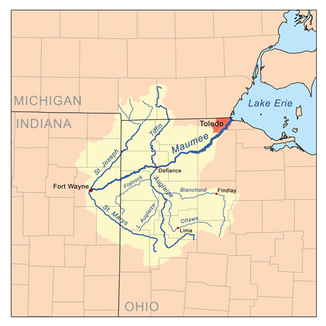
The St. Marys River in the Maumee River basin |
||
| Data | ||
| Water code | US : 442706 | |
| location | Indiana , Ohio (USA) | |
| River system | Saint Lawrence River | |
| Drain over | Maumee River → Niagara River → Saint Lawrence River → Atlantic Ocean | |
| confluence | from East Branch and Center Branch St. Marys River about 2 miles east of the village of St. Marys in western Auglaize County, OH 40 ° 32 ′ 14 " N , 84 ° 21 ′ 46" W |
|
| Source height | 259 m | |
| Union | with the St. Joseph River to the Maumee River (in Ft. Wayne, Allen County, IN) Coordinates: 41 ° 5 ′ 0 ″ N , 85 ° 7 ′ 56 ″ W 41 ° 5 ′ 0 ″ N , 85 ° 7 ′ 56 ″ W |
|
| Mouth height | 230 m | |
| Height difference | 29 m | |
| Bottom slope | 0.18 ‰ | |
| length | 160 km | |
| Catchment area | 2196 km² | |
| Big cities | Fort Wayne | |
The St. Marys River is a roughly 160 km long tributary of the Maumee River in the US states of Indiana and Ohio .
At the confluence with the St. Joseph River , it forms the Maumee River in Fort Wayne , which is part of the St. Lawrence River system . The catchment area including the two source rivers and the numerous tributaries covers 2196 km² and extends over a total of seven counties .
The St. Marys River is formed in western Auglaize County 2 km east of the village of St. Marys by the confluence of the East Branch and the Center Branch St. Marys River . It turns north first, then turns west-northwest after about 12 km and maintains this general direction until it meets the St. Joseph River. It flows through Counties Auglaize, Mercer and Van Wert in Ohio, as well as Counties Adams and Allen in Indiana.
The catchment area is mainly used for agriculture. Approximately 84% consists of arable land, 7% is forest or wetland and the remaining 7% is urbanized or used for other purposes. The largest cities are Fort Wayne and Decatur in Indiana, and Celina and St. Marys in Ohio. The population in the catchment area is around 770,000.
Web links
Individual evidence
- ↑ a b Google Earth altitude for GNIS coordinates, accessed on July 31, 2010.
- ↑ a b St. Marys River (Maumee River) in the Geographic Names Information System of the United States Geological Survey
- ↑ a b c St. Marys River Watershed
