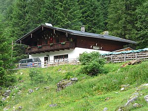
Stockeralm (Untersulzbachtal)
| Stockeralm | ||
|---|---|---|
| location | Untersulzbachtal , Oberpinzgau ; Gem. Neukirchen am Großvenediger , State of Salzburg ; Valley location: Sulzau | |
| Mountain range | Venediger group | |
| Geographical location: | 47 ° 12 '2 " N , 12 ° 17' 30" E | |
| Altitude | 1280 m above sea level A. | |
|
|
||
| owner | Fam. Kaiser, Sulzau | |
| Construction type | Inn | |
| Development | Ziehweg (valley taxi) | |
| Usual opening times | Mid May to mid October | |
The Stockeralm is an alpine pasture and managed mountain inn in the Untersulzbachtal in the municipality of Neukirchen am Großvenediger , in the Venediger Group and in the Hohe Tauern National Park .
Location and landscape
The Stockeralm is located in the front third of the Untersulzbachtal, about four kilometers south of the Salzach Valley near Sulzau , at 1280 m above sea level. A. somewhat above the Untersulzbach, at the foot of the Großer Finagl ( 2730 m above sea level ). Since the front valley is not otherwise cultivated, it is the first alpine pasture in the Untersulzbachtal. It is the only inhabited place in the valley.
The pasture grounds only extend eastwards ( right ) uphill, to the western side is the Finkalm 1391 m .
The hut is located in the buffer zone of the national park, the core zone begins a few 100 meters around the hut.

Stockeralm to the left of “Breitfuß”, unlabeled
- Neighboring locations
| Sulzau | ||
| Finkalm |

|
|
| Abichlalm |
Alpinism
You pass the Stockeralm at the entrance from Neukirchen or Wald via Sulzau and Siggen (Neukirchen municipality) through the Untersulzbachtal, from the Schütthof car park or the Einödhöfe. On the way to the alpine pasture, you pass the Hochfeld show mine near the Knappenwand (epidote finds) and the remains of a sawmill. The way is the Geo-Lehrpfad Knappenweg Untersulzbachtal . The Stockeralm can also be reached by valley taxi.
The Alm is open from mid-May to mid-October, and you can also spend the night there.
The hut serves as a base for tours into the inner Untersulzbachtal. A transition leads over the Finkalm and the Bettlerscharte to the Berndlalm in the Obersulzbachtal, the walking time is 3 to 3.5 hours, the Bettlersteig is only suitable for experienced mountain hikers and partly leads over steep terrain.
Web links
- 50614 - Neukirchen am Großvenediger. Community data, Statistics Austria .
- Stockeralm homepage , stockeralm.at
- Stockeralm - 1,265 m , wildkogel-arena.at
- Stockeralm 1,265 m, Neukirchen , salzburgerland.com
Individual evidence
- ↑ Willi End, Hubert Peterka: Venediger Group: For hikers, mountaineers and climbers Series Alpenvereinsführer: Ostalpen , 5th edition, Bergverlag Rother, 2006, ISBN 978-3-7633-1242-9 , p. 65 ( limited preview in Google Book search).
- ^ Robert Seemann: Geo-Lehrpfad Knappenweg Untersulzbachtal: Venediger Group; Mineral discovery site Knappenwand; Copper mining Hochfeld. Volume 10 of the Natural History Guide to the Hohe Tauern National Park . 2nd edition, Austrian Alpine Association, 2007 ( Weblink , National Park Administration )
- ↑ The hut taxis are a facility of the national park administration in several valleys to provide public transport for visitors. National park taxis at nationalpark.at
- ↑ Hiking in the Obersulzbachtal - with a view of the Großer Geiger , section Der Bettlersteig in Neukirchen , wildkogel-arena.at


