
Roadblock Ponale

The Ponale roadblock ( Tagliata del Ponale in Italian ) is a former Austro-Hungarian fortification in the northern Italian province of Trento . It was built between the 19th and 20th century in the Val di Ledro leading Ponale road in the municipality of Riva del Garda erected.
location
The part of the road block that can be seen today is located at the third road tunnel of the Ponale road, which leads from Riva del Garda along the north-west bank of Lake Garda, at a height of approx. 150 m . on the one hand the barrier extends almost to sea level, on the other hand the uppermost area is about 80 meters above street level.
history
The history of the Ponale lock is marked by a number of different project proposals, which aimed to secure this potential burglary route. In the course of time, one of the most developed barriers of the dual monarchy was created from a simple open gun emplacement, which was almost completely underground.
Period from 1859 to 1866
The first concrete proposal comes from the year 1859 by August von Degenfeld-Schonburg , who at the time of the Second Italian War of Independence planned the construction of a field cannon position on Ponalestrasse. Together with the Ampola plant at Storo, this should prevent the idea of invasion from the Brescia area via the Valle del Chiese and Val di Ledro in the direction of Riva and the north shore of Lake Garda from the outset. In October 1860 the Trento department of the Verona Genius Inspectorate worked out a preliminary project. It provided for a gate with rifle and artillery loopholes to be attached to the third road tunnel seen from Riva, today's fifth tunnel, as well as a field gun position slightly above the second, today third, road tunnel. The definitive project included a brick balustrade for three guns, an attached powder magazine, accommodation barracks for the crew and a portcullis to block the tunnel. In the end, a masonry battery position was built for four guns, which lay behind a protective wall in the firing position, as can be seen from a description from 1865. There was a sentry box near the battery position, which was connected to the position by a walled path. The facility was designed for a crew of 30, who were only considered to be of strategic importance because of their dominant location.

After the lost battle at Bezzecca on July 21, 1866, the Austrian military judged the defense of Riva to be problematic and therefore considered giving up the city and retreating to Trento if the Italian troops under Giuseppe Garibaldi made a further advance . Although it did not come to that and the advance of the Italians on Ponale Street could be stopped by the crossfire of the Lake Garda flotilla and the battery of San Nicolo , the battery position on Ponale Street was blown up on July 25th.
Period from 1867 to 1909
Between 1867 and 1904, various plans for the construction of a new Ponale barrier were presented. Although they were well aware of the strategic importance of Ponale Street, the chronically tight state coffers meant that it was only for projects. Only minor defensive measures were implemented during this time. These included the construction of mine chambers on what was then the third road tunnel in 1879 and between 1897 and 1898 the restoration of the so-called defensive wall built in 1866 .
In April 1904, the Reich Ministry of War ordered the construction of an infantry casemate as a flanking facility on Ponale Strasse, after a decision in this regard had been communicated to the Genies Directorate in Trento at the end of December 1901. In September 1904, the commission responsible for the fortifications of the Austro-Hungarian monarchy, headed by then Chief of Staff Friedrich von Beck-Rzikowsky, decided, among other things, to complete the Ponale barrier for 1905.
The municipality of Riva opposed these construction plans of the genius management and saw the construction of the lock and the associated restrictions an obstacle to the tourist development of the city. For its part, the genius management sought to acquire the land at the second road tunnel and to use the nearby Ponale spring. Since no agreement could be reached, expropriation proceedings were finally initiated by the Geniedirektion Trento, which the municipality reluctantly complied with, but demanded confessions regarding the exclusion zone and the use of the water pipe. On October 19, 1905, an agreement was finally reached after the objection of the governor in Innsbruck about the price that was set too high had to be cleared out of the way. The military authorities also received approval to erect two iron mesh gates on the second road tunnel.
In 1909 the Ponale road block consisted of a grenade-proof flanking system with rifle loopholes at the southern frontal tunnel exit. The area of action of this facility, also known as the Red Plant, was directly in front of the road tunnel. The latter was also part of the barrier and closed with iron gates at both exits. At the northern exit of the tunnel there was an accommodation building in the form of a log house , while an open infantry position was on a mountain ledge east of the road tunnel. The crew of the facility was designed for 2 officers and 72 men.
Period from 1910 to 1918
In 1910, when Riva was also declared a fortress , a new project and construction phase began for the road block. The focus of construction activity was now almost exclusively underground .
In 1911, for example, a cavernous machine gun stand was built for close defense and for swearing in the front. This stand was provided with steel armor and could crossfire the street and the area up to the flanking system 80 m away. In the same year the open infantry position on the mountain ledge east of the road tunnel was given up and instead two positions were built in the longitudinal direction of the tunnel with a 3 × 3 m concrete shelter between the two positions and an observation post that was also concreted. On the side of the throat, the defense was additionally reinforced by wire entanglements.
Shortly before the Italian entry into the war on May 23, 1915, the intelligence service of the 1st Italian Army described, among other things, the Ponale roadblock. It said that the system consists of a guardhouse with two rooms and an ammunition depot, which has armored shutters and loopholes. The trenches originally built for the infantry about 10 m above street level were reported as renewed and, according to the intelligence service, should have been converted into a small covered position, which is probably equipped with small-caliber artillery. The Italians also knew the blockhouse south of the road tunnel and a little above the road. On the other hand, nothing was reported about cavernous areas such as the machine gun stand.
The work on the barrier did not end with the start of the war, on the contrary, during the war the facility underwent its major expansion as a cavernous position. In February 1916, plans for the construction of battery systems in the Ponalesperre were submitted to the Genie Directorate. For this purpose, the mountain was expanded into an underground defense system, in which shelters, ammunition stores, command posts, artillery monitors, searchlights, telephone switchboard etc. were housed, which were spread over several levels. Work on this cavernous facility was carried out in sections. A memorial plaque that was formerly attached above the road tunnel, of which photographs have been preserved, shows not only the builders but also the construction period from 1916 to 1917. However, work was probably also carried out in 1918, which can be deduced from a corresponding year that can be found on a fountain in the factory. A special aspect of the Ponale lock was the orientation of the area of activity of the facility. In the front area, the factory only served as a roadblock, the factory artillery, on the other hand, was directed towards the other side, on the one hand, in order to prevent possible Italian landing attempts on the north bank, on the other hand, it was directed towards the sea side. The front area, on the other hand, was covered exclusively by machine and rifle fire.
.jpg)
After 1918
After the war, the facility fell apart, the iron parts were removed and some of the entrances were bricked up. In the meantime, some areas of the facility also served as material stores for the road maintenance authority. Between 2003 and 2004, at the same time as the realignment of Ponalestrasse into a cycle and hiking path, the roadblock was cleared of debris and some restoration and protection measures were carried out. During this work, two armored door leaves that were still attached to one of the tunnel entrances also disappeared. In September 2003 the Office for the Protection of Monuments of the Autonomous Province of Trento commissioned a project for a museum use of the facility, which was presented to the public in July 2007. The costs for the implementation of the project, including the extensive security measures considered necessary due to the geological conditions, were estimated at around 900,000 euros. As a result, you commission a geological survey, with which you should only specify the costs for the safety measures. According to this report, which was handed over in November 2010, around 650,000 euros would have been necessary to secure a facility that is only partially accessible to the public. As a result, the project of a museum use of the Ponalesperre was frozen. Apart from guided tours that take place at irregular intervals and open days, during which the barrier is also electrically illuminated, the cavernous area of the facility is not accessible to the public.
description
The Ponale roadblock has an almost inconspicuous appearance today. There is little to say about the actual size of the complex, especially since the entrances to the cavernous areas are all blocked off with lattice doors. It extends over a total of 5 levels, with the tunnels being over a kilometer long and overcoming an altitude difference of approx. 120 meters.
First floor
The first level is slightly above the now abandoned and at that time not yet built riverside road, the Gardesana Occidentale . This level is a battery block with connected supply facilities, which was aligned with the firing direction Torbole and the subsequent east bank. In addition to the two artillery caverns for 8 cm rapid-fire cannons, there is also an artillery observation post here. In addition, a card reading room for the alignment of the guns, a telephone room, an officers' quarters, an accommodation for the crews, a service room for the battery and a powder room or ammunition room for the artillery shells were also housed on this level. On this level there is also the fountain with the engraved date 1918. From this level, which is almost at sea level, a concrete staircase with almost 200 steps leads up to the second level 40 m. There was an ammunition elevator running along the rails next to the stairs, of which the bedding can still be seen in parts .
second level
The second level extends at the level of the old Ponale street. At the end of the stairs leading up from the first level there is a gate that leads to the road tunnel. An adjacent second gate leads into the former kitchen room and a storage room. A long tunnel that begins here ends at an observation post in the almost vertical rock face above the lake, which once housed a searchlight. At the northern entrance of the road tunnel, the former backside, is the guard house with the optical signal station, which is aligned with the San Alessandro factory on Monte Brione , which housed a radio station. On the western side of the road tunnel, the first entrance leads to the second cavernous battery. The caverns for the crew quarters, for the fortress commanders and an ammunition cavern for the connected battery were located in this large tunnel at the front. At the end of this tunnel was an artillery observation post and two further artillery caverns for 8 cm rapid-fire cannons firing in the direction of the Torbole-Riva coastal strip, one of the two artillery caverns being walled up in the meantime. At the southern exit of the tunnel, on the east side, is the entrance to the cavernous machine gun stand built in 1911, which, like the flanking system located about 80 m further south-west, was supposed to line the road. The second level also includes that part of the facility that was built east of the road tunnel on a mountain ledge above the lake. This area, also known as Forte Teodosio, because some coins from the time of the Roman Emperor Theodosius I were found here, consists of a few casemates, an artillery booth with a distance table that is still there, a covered infantry booth and an open gun bench. There are also two memorial stones in this area, one commemorates an officer of the fortress who fell here in 1917, the other one to the Roman coins found here.
Third level
The third level begins at the southern tunnel exit on the western side of the tunnel. Here a long tunnel turns in a southerly direction, which divides after about 50 m. The left tunnel leads steeply back up to the surface and ends at the point where the motor of the material ropeway once stood, with which the 4th and 5th levels were supplied. The main tunnel, on the other hand, continues in a southerly direction to another junction, the left one ends at the flanking facility or the Traditor, also known as the red factory because of the exterior paintwork. This tunnel practically represented the bomb-proof access between the plant and the close combat system. The right branch of the main tunnel merges into a spiral tunnel that ends in the open above the traditor. From here a partially open and covered trench leads to the next level.
Fourth level
The fourth level consists of an approx. 300 m long tunnel with numerous loopholes that are located in the rock face above the northern tunnel exit of the fourth road tunnel. The material ropeway also ended at the fourth level, the access window of which can be seen in the tunnel as well as the foundations of the cable car.
fifth level
The fifth and last level of the road block consists of a concrete rifle gallery, which is approx. 20 m above the fourth level. From here it was possible to influence the Val Sperone opposite as well as the further course of the Ponale road. The iron girders were removed from this command post in the post-war period, so that the facility was almost completely destroyed.
Armament
In 1916, the main armament of the facility consisted of four 8 cm M 75/96 rapid-fire cannons. These had been installed as cavern batteries in two separate battery blocks, one almost at sea level on the first level and one about 40 meters further up on the second level at the level of Ponale Street. The direction of fire of these batteries was aimed at the coastal strip between Riva and Torbole or at the adjoining east bank and the sea side. In addition, the lock had two machine gun stands for close defense and three armored rifle galleries, a spotlight stand and several artillery observation posts.
photos
 Tunnel exit front with cavernous position
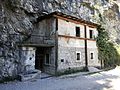 Sentry box on the throat side
 Optical signal station at the sentry box
 Distance plate artillery observer
 The fourth and fifth levels in a recording from the First World War


.jpg)
literature
- Comando I Armata - Ufficio Informazioni: Monograph 5. La Piazza Forte di Riva. Party II . O. O. 1916.
- Nicola Fontana: La regione fortezza. Il sistema fortificato del Tirolo: pianificazione, cantieri e militarizzazione del territorio da Francesco I alla Grande Guerra. Museo Storico Italiano della Guerra , Rovereto 2016.
- Giovanni Fiorini: La Valle di Ledro nella prima guerra mondiale 1915–1918. Temi, Trento 1993.
- Danilo Mussi: Dall'Ampola al Ponale. "Storia" e "storie" sulle strade e sugli accessi della valle di Ledro. Cassa Rurale di Ledro, Trento 2001.
- Donato Riccadonna: Sguardi militari sul Garda. La linea fortificatoria austroungarica dell'Alto Garda ed il fronte italiano. Museo Civico, Riva del Garda 2002.
- Donato Riccadonna, Mauro Zattera: Sentieri di confine. Segni da ritrovare della Prima guerra mondiale nell 'Alto Garda e Ledro. Colpire a distanza dalla preistoria alla Terza guerra mondiale. Associazione Ricardo Pinter, Riva del Garda 2015.
- Arianna Tamburini, Lodovico Tavernini, Marco Ischia: La difesa sotterranea. Il fortress section, settore fortificato di Riva e le sue opere in caverna nella Grande Guerra. Museo Riva del Garda, Rovereto 2007, ISBN 978-88-8446-134-6 .
Web links
References and comments
- ^ Nicola Fontana: La regione fortezza. Il sistema fortificato del Tirolo: pianificazione, cantieri e militarizzazione del territorio da Francesco I alla Grande Guerra pp. 94-106.
- ↑ According to other sources, however, it was removed
- ^ Nicola Fontana: La regione fortezza. Il sistema fortificato del Tirolo: pianificazione, cantieri e militarizzazione del territorio da Francesco I alla Grande Guerra p. 108.
- ^ Nicola Fontana: La regione fortezza. Il sistema fortificato del Tirolo: pianificazione, cantieri e militarizzazione del territorio da Francesco I alla Grande Guerra pp. 194–198.
- ^ Nicola Fontana: La regione fortezza. Il sistema fortificato del Tirolo: pianificazione, cantieri e militarizzazione del territorio da Francesco I alla Grande Guerra pp. 206–211.
- ^ Nicola Fontana: La regione fortezza. Il sistema fortificato del Tirolo: pianificazione, cantieri e militarizzazione del territorio da Francesco I alla Grande Guerra p. 393.
- ↑ a b Short description of Tagliata Ponale in Italian , accessed on April 11, 2017.
- ↑ Comando I Armata - Ufficio Informazioni: Monografia 5. La Piazza Forte di Riva Parte II. P. 7.
- ^ Giovanni Fioroni: La Valle di Ledro nella Prima Guerra Mondiale 1915–1918 p. 75.
- ↑ Report on the road block, including the photo mentioned in Italian, accessed on April 12, 2017.
- ↑ Arianna Tamburini, Lodovico Tavernini, Marco Ischia: La difesa sotterranea. Il fortress section, settore fortificato di Riva e le sue opere in caverna nella Grande Guerra p. 203.
- ^ Restoration project Ponale roadblock from 2007 in Italian (PDF; 3.87 MB), accessed on March 12, 2017.
- ↑ Answer of the cultural department of the Province of Trento to a request for future use of the Ponalesperre in Italian (PDF; 3.67 MB), accessed on March 12, 2017.
- ^ Donato Riccadona, Mauro Zattera: Sentieri di confine. Segni da ritrovare della Prima guerra mondiale nell 'Alto Garda e Ledro. Colpire a distanza dalla preistoria alla Terza guerra mondiale pp. 157–158.
- ^ Donato Riccadona, Mauro Zattera: Sentieri di confine. Segni da ritrovare della Prima guerra mondiale nell 'Alto Garda e Ledro. Colpire a distanza dalla preistoria alla Terza guerra mondiale pp. 158–159.
- ↑ a b c Arianna Tamburini, Lodovico Tavernini, Marco Ischia: La difesa sotterranea. Il fortress section, settore fortificato di Riva e le sue opere in caverna nella Grande Guerra p. 199.
- ↑ This road tunnel was built later and did not exist at the time of the First World War. At that time, the street still passed outside, the route of which still exists today.
- ↑ Donato Riccadonna (ed.): Sguardi militari sul Garda p. 44.
Coordinates: 45 ° 52 ′ 20.6 " N , 10 ° 50 ′ 14.1" E

Battery Doss di Sponde | Battery San Nicolo | Replacement plant Busa Grande | Riva Fortress | Trento Fortress | Vezzena post | Buchensteintal lock | Roadblock Rocchetta | Paneveggio lock | Restricted group Monte Brione | Blocking group Ponale | Roadblock Buco di Vela | Roadblock Gomagoi | Nauders road block | Roadblock Nago | Roadblock Ponale | Colle delle benne factory | Corno plant | Gschwent plant | Mattarello factory | Lusern plant | Pejo factory | Plätzwiese plant | Presanella plant | Sebastiano plant | Serrada plant | Strino plant | Tenna plant | Tombio plant | Tonale plant | Tre Sassi plant | Valmorbia plant | Verle plant | Work groups Folgaria and Lavarone | Intermediate plant Mero | Intermediate work Sommo