
Stymfalia (ecosystem)
The landscape of Stymfalía (Στυμφαλία) around the lake of the same name in the northeast of the Peloponnese is one of the ecological treasures of Greece.

geography
Limni Stymfalia is the Greek name for the lake in the Stymfalia landscape without natural surface drainage. It lies in the middle of a plateau about 2 km wide and 16 km long; it has the shape of a banana slightly curved to the northeast. The in about 600 m above sea level. d. M. lying level is enclosed on all sides by mountains. On the south-eastern lakeshore, the ridge sinks and allows a road pass at a height of approx. 150 m. In the west, the Mavrovouni mountain (1700 m) separates the plain from the much larger Polje Feneos plateau, about 4 km away . In the south, the Oligyrtos Mountains (1934 m) and its foothills limit the plain to the east with 500 - 1000 m high, steep slopes. In the north, the massive Ziria Mountains dominate the plain, with a base radius of around 10 km and 2374 m, the second highest point in the Peloponnese.
geology
The mountain formations and it enclosed sedimentary basins Stymfalia are a karst - Geotop whose (hydro) geological characteristics from the other intra basins distinguish the northeastern Peloponnese: Even in the rain-free and hot seasons of the Peloponnese this lake falls rarely dry.
The mighty Ziria block to the north dominates the Stymfalia geotope. It consists of limestones of Tripolis ceiling and Olonos-Pindos ceiling and from conglomerates of the Neogene . Decisive for the geological and hydrogeological condition of the Polje was a strong elevation , as well as a further, postalpidic block fold , which inclined the Ziria massif to the southeast. The layers were along a 70 degree incident disturbance moved -line km between Feneos and Kastania to about 4.5. As a result of these movements, the southern base was lowered. The formation is clearly visible in the Landsat image (below). Thick Quaternary sediments were deposited in the depression . The impermeable, red, gray and greenish clay layers (typical sediments of stagnant water) are up to 150 m thick.

Stymfalia, flat ground wet until June

Stymfalia, Ziria massif (2374 m); Inflows and outflows marked (Landsat 7, 8 km, false colors, s⇒n)

Tectonic uplift and inclination formed a depression. (Landsat 7, n⇒s, 20 km)

Stymfalia, largest karst spring in the village of Stymfalia, northeast. Seaside

Stymfalia, wet fields: Field cultivation often starts too late

Stymfalia, east: fresh and diverse in spring; old irrigation channel
Stymfalia, resting place for " Stymphalic birds ?"

Pseudophoxinus stymphalicus , protected / endangered fish in the lake

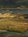
General view, NATURA 2000 Stymfalia, from west to east


Hydrogeology
Strong tectonic movements in the Ziria block have led to the formation of permeable structures towards the southeast, through which almost all of the precipitation is carried away. Surface water from Dhrossopighi in the Ziria is just as insignificant for Stymfalia as the precipitation from the northwestern mountain cut near Kastania (on the western edge of the plains).
Only a part of the water is poured at overflow springs on the southern block edge of the Ziria (level edge) . Another part is led under the depression further to the southeast.
The hydrogeological peculiarities are marked in the Landsat image.
Water catchment area
The lake is fed from two large source areas, Dhriza and Kefalari (Korinthia) and from a neighboring plain. About 8 km from the lake in the northeast, the plain ends at the approx. 100 m high foothills of the southeast mountain range. Behind this spur there is another plain, slowly rising over approx. 5 km. That level has no natural drainage either. A tunnel approx. 600 m long drains the maximum 1 km wide plain towards Stymfalia.
The main drainage of the Ziria massif comes to the surface in the Dhriza spring. The spring rises in several places on the edge of the plain next to the village street of Stymfalias. Above all, it feeds the lake with its pouring that extends into the summer. For seasonal tourism, an exit point was designed to be inviting and a shady garden restaurant was built around it (picture).
At the eastern tip of the "Banana" Stymfalia, which is bent to the north , the second largest karst spring of the Zirias rises in several places of the mighty alluvial and rubble cone on which the village of Kefalari lies . The spring pours less than the Dhriza spring and usually dries up some time before it. Nonetheless, these two water resources are important for the agricultural irrigation of the entire eastern part.
Drainage of the plain
Two natural water outlets over sinkholes (Greek: katavothra, sgl.) Are known, and two artificial outlets. Only the larger sinkhole is active, which lies beyond the normal extent of the flood. A ditch reaching far into the lake to this enclosed and now regulated sinkhole keeps the water level below what it was in earlier times. The ancient, artificial exit is the tunnel that was uncovered and reopened around 1885, followed by an aqueduct to Nemea and the coastal plain. Both parts were built around 130 AD on behalf of the Roman emperor Hadrian (for archeology and the aqueduct, see Stymphalos ).
Underground karst water connections, poljen and karst springs

Graphics of the entire karst area of the NE Peloponnese.
In the karst , surface water penetrates through cracks, crevices, punctiform and flat seepage into the subsoil and forms underground watercourses and caves in order to emerge again with large embankments at impermeable barriers or layer edges. In the north-east of the Peloponnese there is a network of underground waterways that is largely unexplored (as of 2006). The water connection between Stymfalia, its springs and sinkholes on the one hand, underground waterways and distant karst springs on the other hand was already correctly assessed in ancient Greece.
In the years after 1980 a comprehensive (hydro) geological project for the research of karst phenomena of the entire northeast of the Peloponnese, in particular the intramontane basins, produced the first rough mapping of karst waterways. Water marking attempts of this research between dozen of sinkholes and karst springs clarified the water catchment area for Stymfalia and its underground connections to distant karst springs. In the largest spring, Dhriza, marker substances were recorded from two swallow holes about 10 km away in the north-western and northern Ziria ( Skafidia , Megagiani). Marking substances of the active mouth of Stymfalia were detected in the two very large karst springs of Lerni and Kiveri, some 45 km away, directly on the Argolic Gulf coast (see the map on the right). These two very large springs are used to irrigate the Argolida plantations . The water from these springs also comes from other karst formations in the north-eastern Peloponnese.
From 2002 onwards, a water system constructed with modern transport capacity with 1-meter pipelines was laid parallel to the old late antique aqueduct. In 2005 there were repeated protests by the residents of the plain who feared for their local interests. Environmental initiatives and organizations participated because of the unexplained potential ecological consequences. Interventions by Greek courts because of violations of EU law ended a special law to "secure the water needs of large Greek cities". In contrast to the project, the pipeline is operated with the stipulation that water is only taken directly from the Drhiza spring and thus only depending on the discharge (“irrigation protests”).
Biotopes of the Stymfalia Plain
The proximity of high mountains in the vicinity and further afield ensures abundant rainfall, especially in the months of December to May. The mountain slopes are therefore densely forested, on the south side up to the edge of the plain. The rubble cones , which protrude far into the plain, are terraced with stone walls in the lower part and are still used for agriculture. The harmful browsing by sheep and goats due to overgrazing, which is otherwise often observed in the Peloponnese, is absent here. On the plains on both sides of the lake, arable crops dominate , loosened up by individual trees or groups of trees, the latter especially along drainage ditches, which make management difficult but are necessary. Together with groups of fruit trees, bushes, as well as scattered orchards and viticulture, there is a large biodiversity .
Broad strips on the western and eastern sides of the lake are flooded into the months of May or June by the seasonal rise in the water level, or they still show clear traces of it. The lake is covered with a patchwork of ocher-colored reeds. Fresh green reed carpets indicate further expansion. The water surface can double in the rainy season, around 770 ha. In rare, very dry years, only a small swamp-like area of water remains. Occasional, complete drying out has also been handed down, e.g. B. 1988-1990.
Natura 2000 and Fauna-Flora-Habitat Protection for Stymfalia

The EU Directive 92/43 / EU on the conservation of natural habitats and of wild fauna and flora has implemented Greece into national law. The Hellenic Ministry for the Environment, Physical Planning and Public Works has described the NATURA network, mapped it and published it on its website.
The two objects Stymfalische Plain and the south-west bordering Olighirtos Mountains were included in category B for the habitat catalog (GR22, with significant biodiversity, but without unique habitat types or species). The change ban has been implemented; the objectives of Natura 2000 have not yet been achieved. In 2007 the necessary design measures had not yet been started.
Protection of endemic endangered plant and animal species
The habitat description for Stymfalia on the website of the Greek Ministry of Environment (excerpt):
" Habitat type : natural eutrophic lakes with a vegetation type Magnopotamion or Hydrocharition, aegean Phrygana ( Sarcopoterium spinosum ), sclerophyllous wood-pastures (dehesas) with Quercus suber and / or Quercus ilex , eumediterrane Greek limestone, thermo Mediterranean gallery forest (Nerio-Tamaricetae), Pinus nigra ssp. pallasiana forests. Animal species: Rhinolophus hipposideros , Rhinolophus ferrum-equinum , Testudo hermanni , Emys orbicularis , Mauremys caspica , Elaphe situla , Phoxinellus spp. [...] This landscape is a very important refuge for migratory birds and of course a breeding area for many of them. [...] In addition, the area around the lake, with its diverse ecological niches that house a number of plant groups endemic to Greece, has a high ecological diversity. "
In 1983 Greece ratified the international “Convention on the Conservation of European Wildlife and Wildlife and Their Natural Habitats” (Convention), in Appendix III of which the taxon Pseudophoxinus stymphalicus is listed among the protected fish species . This fish was found in Stymfalia. The website describes the exceptional survivability of the species in the mud of the dry lake: "... during the periods when the lake dries up, it survives by sinking into the mud and forming a slimy shell around the body."
Conservation and rehabilitation of Stymfalia, plain and lake
Fertilizing and draining agriculture in a wetland , high-tech water drainage, oversized earth moving for road projects, for agriculture and for land use can endanger the Stymfalia ecosystem. Visible effects on the lake through silting have been registered for a long time ( eutrophication / overfertilization). “Endangerment: (...) Deposition of silt and the subsequent development of a water-loving Phragmites communis vegetation and therefore the reduction in the surface of the lake. Estimates assume a current share of reed-covered area on the lake surface of 55.06%, while it was 33.75% in 1945 and 38.44% in 1960. Intense hunting, illegal or legal, is the main threat to the area's bird life, especially in winter. Effective protection of this fauna is urgently needed. "
Greece has several so-called wetlands (English wetlands ) in the list of international " Ramsar Convention entered for the protection of wetlands, 1971 ff.". Stymfalia is not among them.
Initiatives to protect the environment
The creation or maintenance of a balance between the natural conditions and the current dominance of human settlement and human intervention is difficult in the sparsely populated, economically weak Peloponnese, such as in Stymfalia, but still possible, since the landscape and nature have not yet been irreparably damaged.
National and regional subdivisions of NGOs such as BirdLife International , Hellenic Ornithological Society, Hellenic Society for the Protection of Nature and initiatives such as the Konrinther EPEK take care of the recording on the basis of the Fauna-Flora-Habitat Directive of the EU and other platforms, Description and protection of fauna, flora, nature and ecosystems. A number of projects to develop the infrastructure of the Peloponnese are carried out by Greece with funds from EU funds.
References and comments
- ↑ Hötzl in Morfis et al., P. 135 f.
- ↑ Hötzl in Morfis et al., P. 136
- ↑ See e.g. B. Pausanias VIII, 22, 3
- ↑ Morfis et al. P. 278 ff.
- ↑ a b c natura.minenv.gr: "Environmental Protection", Natura 2000 in Hellas: Limni Stymfalia ( Memento from July 21, 2011 in the Internet Archive ) (English)
- ↑ EPEK: local initiative EPEK (orinthos) on Limni Stymfalia ( Memento from January 4, 2007 in the Internet Archive ) (Greek)
- ↑ a b minenv.gr/biotopes: Stymfalia Habitat Types ( Memento of the original from September 28, 2007 in the Internet Archive ) Info: The archive link was inserted automatically and has not yet been checked. Please check the original and archive link according to the instructions and then remove this notice. (English)
- ↑ Page "Environmental Protection" = Περιβάλλοντος on the above. Website natura.minenv.gr
literature
- A. Morfis (Ed.), "Karst Hydrogeology of the Central and Eastern Peloponnesus (Greece)." In: Styrian contributions to hydrogeology 1986. (4.3: “Polje of Stymphalia”, page 127ff.) (English)
- Directive 92/43 / EU on the conservation of natural habitats and wild animals and plants, i. d. F. von 97/62 / EG of October 27, 1997, PDF file
- Directive 2004/35 / EC (PDF)on environmental liability for the prevention and remediation of environmental damage
- minenv.gr: Hellenic Ministry for the Environment, Physical Planning & Public Works; NATURA 2000, Dept. Management for Nat. Env .; Menu with 7 topics
- Description of Greece; Pausanias (Periegeta), translated into German by Ernst Meyer , Zurich, 1954
- Convention of the Council of Europe and other signatories on the conservation of European wild plants and animals and their natural habitats, Bern 1979
Web links
- Stymfalia: Young reporters for environment, Greece (English)
- Lecture on environmental protection and nature conservation in the prefecture of Konrinth (Greek; illustrative image and statistical material ( memento from September 28, 2007 in the Internet Archive ))
- minenv.gr/biotopes: Stymfalia Habitat Types (English)
- Important bird areas in Greece: Stymfalia Lake (English)
- Birdlife , factsheet GR 117, Lake Stymphalia (English)
- Hellenic Society for the Protection of Nature, national operator (English)
- Bern Convention, 1982