Taketa
| Taketa-shi 竹田 市 |
||
|---|---|---|
|
|
||
| Geographical location in Japan | ||
| Region : | Kyushu | |
| Prefecture : | Ōita | |
| Coordinates : | 32 ° 58 ' N , 131 ° 24' E | |
| Basic data | ||
| Surface: | 477.67 km² | |
| Residents : | 20,434 (October 1, 2019) |
|
| Population density : | 43 inhabitants per km² | |
| Community key : | 44208-9 | |
| Symbols | ||
| Tree : | maple | |
| Flower : | Rhododendron kiusianum | |
| Bird : | Japanese Bush Warbler | |
| town hall | ||
| Address : |
Taketa City Hall 1650 Ōaza Aiai Taketa -shi Ōita 878-8555 |
|
| Website URL: | Taketa | |
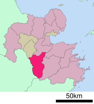
| Location Taketas in Oita Prefecture | ||
Taketa ( Japanese 竹田 市 , - shi ) is a city in Ōita prefecture in Japan on the island of Kyushu . It belongs to the Naoiri district.
geography
Taketa is located about 40 km southwest of Ōita and just under 70 km west of Saiki and Usuki in the north of the Japanese island of Kyushu. Kumamoto is about 80 km southwest.
history
Taketa is an old castle town where the Nakagawa resided from 1600 to 1868 . The place was also called "Oka" after the castle.
On March 31, 1954, the villages of Taketa, Tamarai, Matsumoto, Nyūta, Ubatake, Miyato, Sugō, Miyagi and Kibaru were combined to form the city of Taketa. In 1955 Ōazakatase was incorporated. On April 1, 2005, the places Kujū and Naoiri in the north and Ogi in the southwest of the city were incorporated into Taketa. In these last-named districts today, there are separate administrative branches.
traffic
- Streets:
- Ōita highway
- National Road 57: Ōita - Kumamoto - Nagasaki
- Railroad:
- JR Hōhi main line : to Kumamoto or Ōita
Town twinning
-
 San Lorenzo , since 1973
 -
 Bad Krozingen (Germany) Baden-Württemberg , since 1987
sons and daughters of the town
- Anami Korechika (1887–1945), Japanese general and army minister in World War II, committed ritual suicide after the Japanese surrender on August 15, 1945 .
Neighboring cities and communities
|

