Le Tanet
| le Tanet (Tanneck) |
||
|---|---|---|
|
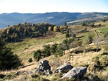
Summit of Tanet, view of the Grand Ballon (left) and Petit Hohneck (right) |
||
| height | 1292 m | |
| location | Alsace / Lorraine border ; Départements Vosges / Haut-Rhin , France | |
| Mountains | Vosges | |
| Dominance | 1.8 km → Gazon de Faîte | |
| Notch height | 66 m ↓ southeast of the Tourbière du Tanet (high moor) | |
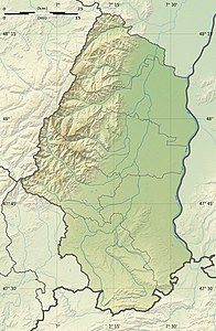
| Coordinates | 48 ° 5 '0 " N , 7 ° 3' 7" E | |
|
|
||
| rock | granite | |
The Tanet (on the French maps with article: le Tanet , German (occasionally): Tanneck ) is a 1292 m high mountain in the High Vosges , three kilometers northeast of the Col de la Schlucht .
Location and topography
The Tanet and the south-westerly, only 4 meters lower root stone, form an extensive double peak that sits on the 40-kilometer-long main ridge of the High Vosges, which nowhere falls below 1100 meters. The border between the departments of Vosges and Haut-Rhin , Alsace and Lorraine runs across the ridge . Between Tanet and Gazon de Faîte (1303 m) in the north there is an upland moor that has been designated as a nature reserve ( Réserve naturelle ). The western flank of the ridge falls around 450 meters down to the valley of the upper Meurthe , with the high heaths merging down into mixed forests of beech, fir and spruce. To the east, for Rhein level out the peak formed by cliffs breaks abruptly over an approximately 100 meter high rock face in the Karböden of Seestaettle off and a further 300 meters in Coombs above Soultzeren .
Development
West of the Tanet, the Route des Crêtes runs between Col de la Schlucht and Lac Blanc . The GR 5 long-distance hiking trail runs over the ridge . From the east, the Tanet can be climbed from the Ferme-Auberge Seestaettle on two paths, with the southern part running over a ski slope.


