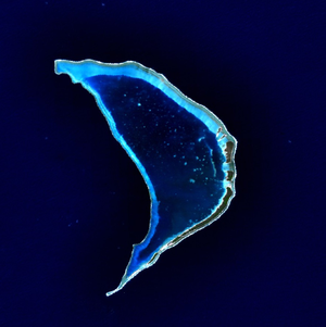
Bokak
| Bokak (Taongi) | ||
|---|---|---|
| NASA image by Bokak | ||
| Waters | Pacific Ocean | |
| archipelago | Marshall Islands | |
| Geographical location | 14 ° 31 ' N , 169 ° 0' E | |
|
|
||
| Number of islands | 10 | |
| Main island | Sibylla Island (Bok-Ak) | |
| Land area | 2.0 km² | |
| Lagoon area | 48.5 km² | |
| Residents | uninhabited (2002) | |
| Map of the atoll | ||
Bokak or Taongi (German outdated: Petrelinsel ; Gaspar Rico and Smyth Island) is the northernmost atoll of the Ratak chain and thus the northernmost land mass of the Marshall Islands . The uninhabited atoll has a land area of 1.25 km² with a lagoon area of 30.31 km². The atoll of Bikar, 280 km away, is closest to Bokak.
The main islands, seen from north to south, are:
- North Island
- Kamwome
- Bwdije (Bwideje)
- Sibylla Island (Jipila)
- Pokak (Bok-ak)
- Bwokwla (Bok-ḷā)
The atoll was discovered by Alonso de Salazar on August 21, 1526.
On the island are u. a. Frigate birds and the Australian tern are native.
literature
- James E. Maragos: Description of reefs and corals for the 1988 protected area survey of the Northern Marshall Islands, Atoll Research Bulletin, No. 419, August 1994 (PDF; 11.6 MB)
- David Stanley: Micronesien Handbuch; Verlag Gisela E. Walther; 1987; p.76
Web links
- Image and short description (Engl.) ( Memento of 23 December 2010 at the Internet Archive )
- Images and short description of birdlife (English)
- Geographical information (English)
Individual evidence
- ↑ German Colonial Lexicon. Edited by Heinrich Schnee. - Leipzig: Quelle & Meyer 1920. - 3 vols.
- ↑ Place Names of the Marshall Islands (from the PALI edition of the Marshallese-English Dictionary) (name variants)


