Tartas (river)
|
Tartas Тарта́с |
||
|
Course of the Tartas (Тартас) in the catchment area of the Irtysh |
||
| Data | ||
| Water code | RU : 14010200112115300004954 | |
| location | Novosibirsk Oblast ( Russia ) | |
| River system | If | |
| Drain over | Om → Irtysh → Ob → Arctic Ocean | |
| source |
Wassjuganje 56 ° 22 ′ 25 ″ N , 80 ° 20 ′ 4 ″ E |
|
| Source height | approx. 140 m | |
| muzzle |
Om northeast Tatarsk Coordinates: 55 ° 37 ′ 6 " N , 76 ° 43 ′ 59" E 55 ° 37 ′ 6 " N , 76 ° 43 ′ 59" E |
|
| Mouth height | 94 m | |
| Height difference | approx. 46 m | |
| Bottom slope | approx. 0.08 ‰ | |
| length | 566 km | |
| Catchment area | 16,200 km² | |
| Discharge at the Wengerowo A Eo gauge : 16,200 km² Location: 21 km above the estuary |
MNQ 1939/2000 MQ 1939/2000 Mq 1939/2000 MHQ 1939/2000 |
2.8 m³ / s 21.2 m³ / s 1.3 l / (s km²) 90.9 m³ / s |
| Left tributaries | Ures | |
| Right tributaries | Arynzas, Ises | |
| Communities | Severnoye , Wengerowo | |
| Navigable | 370 km (from Severnoye) | |
|
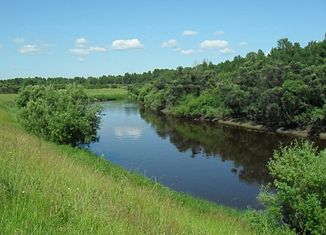
The Tartas near the village of Graschdanzewo, a little below Severnoye |
||
The Tartas ( Russian Тарта́с ) is a 566 km long right tributary of the Om in Western Siberia ( Russia ).
course
The river has its source in the Wassyugan swamps at a height of almost 140 m . The source is in the north of Novosibirsk Oblast , whose territory the Tartas flows through its entire length, not far from the border with Tomsk Oblast , almost 130 km north of Kargat as the crow flies . Near the source, the Tartas crosses the small Karassjowo lake and then flows in a westerly direction through a flat landscape characterized by birch and pine forests . In the middle course, the river turns in a south-easterly and finally in a southerly direction, reaching the steppe areas that characterize the southern part of Western Siberia . It flows increasingly strongly meandering through a less pronounced valley and finally flows into the Irtysh tributary Om at the village of Stary Tartas, about 60 kilometers northeast of the city of Tatarsk . Near the mouth, the Tartas is a good 30 meters wide and over 1.5 meters deep; the flow velocity there is 0.2 m / s.
The Tartas has relatively few, smaller tributaries; the most important are Arynzas and Ises from the right and the Ures from the left.
Hydrology
The catchment area of the Tartas covers 16,200 km². The river freezes over from the second half of October / first half of November to the second half of April / first half of May.
The mean annual runoff at the Wengerowo gauge 21 km above the mouth is 21.2 m³ / s with a minimum monthly average of 2.8 m³ / s in February and a maximum of 90.9 m³ / s in May. The floods during the snowmelt last from April to June.
Infrastructure
From Severnoye, the Tartas is considered navigable (for smaller vessels) over a length of 370 km, but is no longer included in the list of inland waterways in Russia.
There are no cities on the river, but with the exception of the upper reaches in the area of the Wassjugan Marshes there are a large number of villages. The most important are the Rajon administrative centers Severnoje on the middle course and Wengerowo not far from the mouth. There the old route of the M51 trunk road between Omsk and Novosibirsk crosses the Tartas; the villages along the river are connected by partly unpaved local roads.
Individual evidence
- ↑ a b c Article Tartas in the Great Soviet Encyclopedia (BSE) , 3rd edition 1969–1978 (Russian)
- ↑ a b Tartas in the State Water Register of the Russian Federation (Russian)
- ↑ a b Tartas at the Wengerowo gauge - hydrographic data from R-ArcticNET
- ↑ List of Inland Waterways of the Russian Federation (Government Ordinance of December 19, 2002, Russian)

