
Taupo Volcanic Zone


The Taupo Volcanic Zone is an active volcanic area on the North Island of New Zealand . It is named after Lake Taupo , the flooded caldera of the largest volcano in this zone.
activity
The zone is home to numerous volcanic vents and geothermal fields , of which Mount Ruapehu , Mount Ngauruhoe, and the White Island volcano are the most common. The most significant eruption since Europeans arrived in New Zealand was that of Mount Tarawera in 1886, killing more than 100 people. After the arrival of the first Māori , a much larger eruption of the same volcano took place around 1300.
Lake Taupo's last major eruption, the Hatepe eruption , occurred in 181. It is believed to result in a pyroclastic flow that covered approximately 2,000 square kilometers of volcanic ash . The amount of material discharged was estimated at 120 km³, of which over 30 km³ in just a few minutes. The date of the eruption is known as the ashes resulted in a red colored sky in Rome and China . The latter was documented in the Hou Hanshu .
About 26,000 years ago, the Oruanui eruption was an even larger eruption with an estimated 1170 km³ volume. It was the youngest eruption in the world to reach VEI-8, the highest level of the volcanic explosion index .
The Rotorua Caldera has not been active for a long time, the most significant eruption occurred around 240,000 years ago, but lava domes have been formed in the last 25,000 years .
Extent and geological context
The Taupo Volcanic Zone is approximately 350 km long and 50 km wide. Mount Ruapehu marks its southwestern end, the submarine Whakatane volcano 85 km off White Island is considered the northeastern border.
It forms the southern part of the active Lau-Havre-Taupo- Backarc basin , which lies behind the Kermadec-Tonga subduction zone . Volcanic activity continues north-northeast across several subsea volcanoes from the Taupo Volcanic Zone, including Clark , Tangaroa , the Silents, and the Rumbles . Then the active zone turns to the east of the parallel volcanic chain of the Kermadec Islands and the island of Tonga . Although the Backarc Basin continues to the southwest (the South Wanganui Basin was the original basin), no volcanic activity is known from this region. The Taupo Volcanic Zone can therefore be viewed as the southwestern end of the Pacific Ring of Fire , which marks the subduction zones around the Pacific.
South of Kaikoura , the plate boundary changes into a transform fault , at which the tectonic plates pushing one another uplift the Southern Alps on the South Island . Another subduction zone begins southwest of Fiordland on the southwest corner of the South Island, but here in the opposite direction. Solander Island is an extinct volcano associated with this subduction zone, along with other undersea volcanoes.
Studies showed that the earth's crust under the Taupo Volcanic Zone is only 10 miles thick. A 50 km wide and 160 km long layer of magma lies just ten kilometers below the surface. The geological findings show that some of the volcanoes rarely erupt, but then show large, explosive and devastating eruptions.
Volcanoes, lakes and geothermal fields

The Taupo Volcanic Zone includes the volcanic centers of Rotorua, Okataina, Maroa, Taupo, Tongariro and Mangakino.
-
Whakatane Trench, Bay of Plenty
- Whakatane volcano (submarine volcano)
- Mayor Island
- Whale Island
- White Island
- Mount Edgecumbe
- Geothermal field
-
Rotorua Volcanic Center
- Rotorua Caldera
- Ngongotaha (volcano)
- Lakes
- Geothermal fields
- Tikitere / Hell's Gate
- Whakarewarewa
- Takeke
-
Okataina Volcanic Center
-
Okataina Caldera
- Haroharo Caldera
- Haroharo volcanic complex
- Mount Tarawera and Tarawera Volcanic Complex
- Haroharo Caldera
- Rotoma caldera
- Lakes
- Lake Okataina
- Lake Tarawera
- Lake Rotokakahi (Green Lake)
- Lake Tikitapu (Blue Lake)
- Lake Okareka
- Lake Rotomahana
- Lake Rotoiti
- Lake Rotoma
- Lake Rotoehu
- Geothermal fields
-
Okataina Caldera
-
Maroa Volcanic Center : The Maroa Caldera is located in the northeast of the Whakamaru Caldera, the Whakamaru Caldera partially overlaps the Taupo Caldera in the south. The Waikato River follows the north rim of the Maroa Caldera. The town of Whakamaru and Whakamaru Reservoir on the Waikato River also have the same name.
- Maroa Caldera
- Reporoa caldera
- Whakamaru Caldera
- Geothermal fields
- Wai-O-Tapu
-
Wairakei
- Craters of the Moon (Karapiti)
- Orakei Korako
- Ngatamariki
- Rotokaua
- Ohaaki Power Station
-
Taupo Volcanic Center
- Taupo Caldera
- Ben Lomond
- Lakes
- Lake Taupo
- Horomatangi reefs
- Motutaiko Island
- Lake Taupo
- Geothermal fields
- Tawhara Taupo
-
Tongariro Volcanic Center : Lake Taupo, Kakaramea, Pihanga, Tongariro, and Ruapehu are roughly in line on the main fault.
- Kakaramea
- Pihanga
- Mount Tongariro and Tongariro Vuclane Complex
- Mount Ruapehu
- Lakes
- Geothermal fields
- Ketetahi Springs
- Mangakino Volcanic Center
There is also another classification of the volcanic zone:
- Northern part: Whakatane Trench - Bay of Plenty
- Central part:
- west of the main fault:
- Mangakino Caldera Complex; possibly transition to the Coromandel Volcanic Zone (CVZ) (0.91-1.62 million years old)
- Kapenga Caldera; between the Maroa Caldera and the Rotorua Caldera, completely covered by recent tephra , about 700,000 years old
- Okareka Inlet, within the northern end of the Kapenga Caldera, between the Tarawera Volcanic Complex and Lake Rotorua
- "Rotorua single event caldera" made of Mamaku ignimbrite (originated from a single eruption about 240,000 years ago)
- Main disorder:
- Okataina Caldera Complex
- Haroharo Caldera Complex
- Tarawera volcanic complex
- Okareka Bay
- Haroharo Caldera Complex
- Whakamaru Caldera Complex
- Maroa Caldera
- "Ohakuri single event caldera"; Ohakuri ignimbrite; lies west of the Ohakuri Dam , the Waikato River roughly follows the southern edge of the caldera (formed in a single eruption about 240,000 years ago).
- Taupo Caldera Complex
- Okataina Caldera Complex
- east of the main fault:
- "Reporoa single event caldera"; Kaingaroa ignimbrite (formed in a single eruption about 240,000 years ago)
- west of the main fault:
- Southern part: Tongariro volcanic center
gallery

Southwest side of Mount Tarawera, with Mount Edgecumbe in the background

Rotorua Caldera
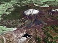
Mount Ruapehu satellite image

Panorama over Lake Taupo


See also
Web links
- New Zealand, Taupo and Coromandel volcanic zones
- Bruce F. Houghton : Field Guide - Taupo Volcanic Zone 2007.
Individual evidence
- ^ Lowe David: Polynesian settlement and impacts of volcanism on early Maori society . In: DJ Lowe (Ed.): Guidebook for 'Land and Lakes' field trip, New Zealand Society of Soil Science Biennial Conference, Rotorua, 27.-30. November 2006 . New Zealand Society of Soil Science, pp. 50-55.
- ↑ Rotorua in the Global Volcanism Program of the Smithsonian Institution (English)
- ↑ JA Gamble, IC Wright, JA Baker: Seafloor geology and petrology in the oceanic to continental transition zone of the Kermadec ‐ Havre ‐ Taupo Volcanic Zone arc system, New Zealand . In: The Royal Society of New Zealand (Ed.): New Zealand Journal of Geology and Geophysics . tape 36 , No. 4. Wellington 1993, pp. 417-435 , doi : 10.1080 / 00288306.1993.9514588 (English).
- ^ LM Parson, IC Wright: The Lau-Havre-Taupo back-arc basin: A southward-propagating, multi-stage evolution from rifting to spreading . In: Tectonophysics . 263, 1996, pp. 1-22. doi : 10.1016 / S0040-1951 (96) 00029-7 .
- ^ P. Villamor, KR Berryman: Evolution of the southern termination of the Taupo Rift, New Zealand . In: The Royal Society of New Zealand (Ed.): New Zealand Journal of Geology and Geophysics . Volume 49, Issue 1. Wellington 2006, pp. 23–37 , doi : 10.1080 / 00288306.2006.9515145 (English).
- ^ Paul Easton: Central North Island sitting on magma film . The Dominion Post. September 15, 2007. Retrieved March 16, 2008.
- ^ W. Heise, HM Bibby, TG Caldwell: Imaging magmatic Processes in the Taupo Volcanic Zone (New Zealand) with Magnetotellurics . In: Geophysical Research Abstracts . 9, 2007. 01311.
- ^ JW Cole: Structural control and origin of volcanism in the Taupo volcanic zone, New Zealand . In: Bulletin of Volcanology . 52, 1990, pp. 445-459. doi : 10.1007 / BF00268925 .
- ^ New Zealand . Retrieved February 3, 2011.
- ^ Okataina Volcanic Center, New Zealand. Oregon State University, accessed January 24, 2016 .
- ^ A b KA Hodgson, IA Nairn: The Sedimentation and Drainage History of Haroharo Caldera and The Tarawera River System, Taupo Volcanic Zone, New Zealand . In: Bay of Plenty Regional Council (Ed.): Environment Bay of Plenty Operations Publication . tape 2004/03 . Whakatane August 2004 (English, Online [PDF; 488 kB ; accessed on January 24, 2016]).
- ↑ JW Cole, KD Spinks: Caldera volcanism and rift structure in the Taupo Volcanic Zone, New Zealand . In: Geological Society (Ed.): Special Publications . 327, 2009, pp. 9-29. doi : 10.1144 / SP327.2 .
- ↑ J. Hiess, JW Cole, KD Spinks: High-Alumina Basalts of the Taupo Volcanic Zone, New Zealand: Influence of the Crust and Crustal Structure. Part of a BSc Project by Hiess, J. (University of Canterbury). 2007, p. 36.
- ↑ DM Gravley, CJN Wilson, MD Rosenberg, GS Leonard: The nature and age of Ohakuri Formation and Ohakuri Group rocks in surface exposures and geothermal drillhole sequences in the central Taupo Volcanic Zone, New Zealand . In: New Zealand Journal of Geology and Geophysics . 49, 2006, pp. 305-308. doi : 10.1080 / 00288306.2006.9515169 .