
Teufelsbach (Radau)
| Teufelsbach | ||
 Teufelsbach in Radauer Holz |
||
| Data | ||
| location | District of Goslar , Lower Saxony , Germany | |
| River system | Weser | |
| Drain over | Radau → Oker → Aller → Weser → North Sea | |
| source | Weiher near Harlingerode 51 ° 54 ′ 51 ″ N , 10 ° 32 ′ 4 ″ E |
|
| Source height | 200 m above sea level NHN | |
| muzzle |
Radauer Holz near Vienenburg Coordinates: 51 ° 55 ′ 59 ″ N , 10 ° 33 ′ 14 ″ E 51 ° 55 ′ 59 ″ N , 10 ° 33 ′ 14 ″ E |
|
| Mouth height | 168 m above sea level NHN | |
| Height difference | 32 m | |
| Bottom slope | approx. 11 ‰ | |
| length | approx. 3 km | |
| Catchment area | 2.5 km² | |
| Small towns | Goslar- Vienenburg | |
| Communities | Harlingerode | |
The Teufelsbach ( Oker dialect : Duiwelsbeke ) is about three kilometers orographically left tributary of the Radau in the area of the cities of Bad Harzburg and Goslar in the Goslar district .
course
The Teufelsbach begins in a retention basin on the edge of the Güdeckeberg in Hackelkamp at a height of 200 m . The corridor borders on the Bad Harzburg district of Harlingerode and became the building site for an industrial area in the late 1990s. In the upper reaches after the immediate source section, the Teufelsbach has been very much straightened, but despite the intensive agricultural use on the bank it is covered with bushes. About halfway the stream flows into the Radauer Holz , from here it shows a very natural course. Within the Radauer Holz, the brook enters a break that has been known since ancient times as the Teufelsbad and gives the brook its name. The lowland has a high rate of unnamed rivulets that rarely exceed a few hundred meters in length and only occasionally carry water. To the east of the forest, the Teufelsbach crosses under the Braunschweig – Bad Harzburg railway line and flows into the Radau about 100 meters further east .
history
The Teufelsbad was first attested in writing in 1528. The exact background of the name is unclear. An entry in the magazine Braunschweigische Heimat in 1982 suggests that it is a typical demonization of field names that were used as pagan places of worship in earlier times . The parcel to the west of the Teufelsbach is also called "Teufelskamp".
Water quality
A determination of the saprobic index by the NLWKN was not possible for the Teufelsbach due to its species poverty. However, the generously designed canal-like course in the upper course with sections of piping and light vegetation suggests a rather poor water quality. Furthermore, the stream often falls dry in summer, so that in the upper reaches the livelihood for living things in the stream is temporarily lost completely. In the Radauer Holz area, however, the situation is improving and the Teufelsbach runs close to nature in a marshy river valley .
Mayflies of the genus Caenis luctuosa can be found on the Teufelsbach as a nature-protected species .
gallery
Retention basin in the source area
Video in the middle reaches of the Teufelsbach
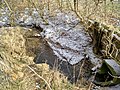
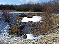
Entry into the Radauer Holz

South of Vienenburg in the Radauer Holz, natural course


Web links
literature
- Braunschweigischer Landesverein für Heimatschutz: Braunschweigische Heimat, Volumes 68-72 . 1982. pp. 107-109.
swell
- Publications of the state of Lower Saxony on the water quality of the Oker and its tributaries on www.wasserblick.net
- List of water bodies in the Outer catchment area with data Publication by NLWKN on www.wasserblick.net
- Water quality report Oker 2002 Internet platform of the NLWKN