
Thülsfeld dam
| Thülsfeld dam | |||||||
|---|---|---|---|---|---|---|---|
 |
|||||||
|
|||||||
|
|||||||
| Coordinates | 52 ° 55 '10 " N , 7 ° 56' 29" E | ||||||
| Data on the structure | |||||||
| Construction time: | 1924-1927 | ||||||
| Height above the river bed : | 11.18 m | ||||||
| Crown length: | 3100 m or 5043 m | ||||||
| Data on the reservoir | |||||||
| Water surface | 1.7 km² | ||||||
| Storage space | 10.8 million m³ | ||||||
| Catchment area | 133 km² | ||||||
| Particularities: |
Nature reserve " Thülsfeld dam " |
||||||

The Thülsfelder Dam is a reservoir between Cloppenburg and Friesoythe in the Oldenburger Münsterland . It borders on the communities of Friesoythe, Garrel and Molbergen and was built between 1924 and 1927 to protect the Soeste riverside regions from flooding. With a storage volume of 10.8 million cubic meters, it is one of the " large dams " and is the northernmost reservoir in Germany after the Brohm dam.
Origin and use
The dam was created by a resolution of the Oldenburger Landtag in 1923, because the Soeste could not drain the water in its narrow river bed during heavy rain or snowmelt. This regularly led to floods in the Friesoythe area. The construction work for the only dam in the Lower Saxon lowland, which was initially used for flood protection , began in 1924. It was built near Thülsfeld on a natural geeste gorge . The 3.1 km long dam built in the process has a 70 m wide bottom and a height of 9 m. When the water is completely blocked, the water depth is 5 m.
Today the dam is also used to raise the low water level of the Soeste and the coastal canal , as well as for local recreation, sport fishing and nature conservation. 3.52 million m³ are provided as a flood protection area. The reservoir is a typical flatland lake that has extensive shallow water zones. These are a valuable habitat for endangered animal and plant species.
The system is operated by the Lower Saxony State Agency for Water Management, Coastal Protection and Nature Conservation, Cloppenburg office. There is also a “Zweckverband Recreation Area Thülsfelder Talsperre” in Cloppenburg.
The heathland west of the Thülsfeld dam represent protected habitats of European importance in accordance with the Fauna-Flora-Habitat Directive (FFH-RL). Together with the reservoir and the lake, the forests of the state of Lower Saxony are declared to the EU in 1999 as habitats to be protected been reported. The area has been designated as the “ Thülsfeld Dam ” nature reserve since 1937 .
Redevelopment
The dam was renovated from June 2002 to 2006. The outlet structure in the final dam and the company building were renewed. The dam was also reinforced. By the time it was completed, the storage capacity was limited to half. Due to construction defects, most of the dam was emptied in February 2009.
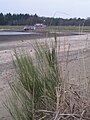
Thülsfeld dam after emptying (March 2009)
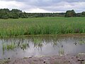
Low level at the Soesten Influence (June 2009)
Slow re-accumulation of the Soeste (July 2009)


free time activities
For recreational recreation, the dam has, among other things, several campsites and a golf course, as well as a climbing forest since 2005 . New Year's Eve runs and triathlons are also offered. There are also two sandy beaches guarded by the German Life Saving Society (DLRG) .
In 2012 there were over 301,000 overnight stays around the dam, of which over 130,000 were in the holiday area in Dwergte . Compared to the previous year, this is an increase of over 1 percent. In addition, over 1.5 million day visitors were counted in 2007, with whom a turnover of 36.9 million euros was achieved.
Picture gallery

Outlet channel behind the dam, October 2005

Heather bloom on the west bank, September 2005

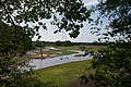
Dam in May 2014

Normal filling with a dam, May 2007

Café at the Thülsfelder dam, at the campsite, Drei-Brücken-Weg


Panoramic shots

.jpg)

See also
literature
- Ernst Andreas Friedrich : Designed natural monuments of Lower Saxony , Landbuch-Verlag, Hanover 1982, ISBN 3-7842-0256-X
Individual evidence
- ^ District of Cloppenburg: Press release ( Memento from October 20, 2007 in the Internet Archive ). January 23, 2006
- ^ Region Thülsfelder Talsperre ( Memento from March 4, 2018 in the Internet Archive )
- ↑ Land & Forest: Flood protection - Thülsfelder dam is dry . March 11, 2009 ( page no longer available , search in web archives ) Info: The link was automatically marked as defective. Please check the link according to the instructions and then remove this notice.
- ^ Water rescue service - DLRG local group Garrel eV In: garrel.dlrg.de. DLRG local group Garrel eV, accessed on December 30, 2016 .
- ↑ Oldenburgische Volkszeitung , Angelika Hauke: March 29, 2008, p. 16