Thülsfeld dam
|
Thülsfeld dam
|
||
| location | Between Friesoythe and Cloppenburg , Cloppenburg district , Lower Saxony | |
| surface | 4.62 km² | |
| Identifier | NSG WE 060 | |
| WDPA ID | 82684 | |
| Geographical location | 52 ° 55 ' N , 7 ° 56' E | |
|
|
||
| Sea level | from 22.5 to 30 m | |
| Setup date | March 9, 1957 | |
The Thülsfeld dam is a nature reserve in the Lower Saxony communities of Molbergen and Garrel and the town of Friesoythe in the district of Cloppenburg .
The nature reserve with the sign NSG WE 60 is around 462 hectares in size. Most of the 434 hectare FFH area “Heiden und Moore at the Thülsfeld dam” lies within the nature reserve. To the south the nature reserve borders on the landscape protection areas “Soestetal between Cloppenburg and Neumühlen” and “Dwergter Sand”, to the north the landscape protection area “Soestetal between Talsperre and Friesoythe” is connected. The area has been under protection since March 9, 1957. It replaces the nature reserve designated on February 5, 1938. The responsible lower nature conservation authority is the district of Cloppenburg.
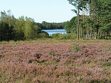
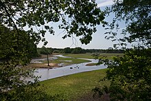
The nature reserve is roughly between Friesoythe and Cloppenburg . Over a length of around five kilometers (with normal damming), it represents the 165-hectare Thülsfeld reservoir with several small islands, the areas surrounding it and part of the Soeste that flows into the reservoir with areas bordering the river in a slightly hilly area formed from ground moraines Geest landscape with inland dunes under protection. The reservoir has ample areas of shallow water with Laichkraut- and frogbit companies and banks bay rich zone with reeds , sedge , willow bushes and predominantly of alder and birch formed swamp forests . To the west of the reservoir are heather and dry sand areas. The heather areas are dry to moist, depending on the location. They are dominated by common heather in dry locations . In some places crowberry also predominates. English and hairy gorse settle in between . Bell heather dominates in damp locations . Silver grass and ostrich grass settle on the sandy areas . Large areas of the nature reserve west and south of the reservoir are wooded with pine , oak and beech forests . English oak and sessile oak dominate the oak forests . Furthermore falter here sand and downy birch , rowan , aspen and with small amounts and beech . In places, historical Hute and coppice forests falter . The beech forests are pronounced as grove beech forests. In the nature reserve, there are small areas of peat moss, swinging lawns , gale bushes and small raised bogs.
Above the reservoir, the Soeste runs close to nature in its partially moist and muddy lowland . It is often accompanied by woods or flows through a wooded valley. In the Soeste flooding settled aquatic vegetation .
The Thülsfeld reservoir is the habitat of a species-rich water bird fauna . It is also of particular importance as a resting area for numerous water birds during migration .
The nature reserve is also used for local recreation and tourism. There are several campsites outside the nature reserve on the north and east banks of the Thülsfeld reservoir . Several hiking trails run through the nature reserve . Since October 2017 there is an approximately ten kilometer long adventure trail with 14 stations.
The nature reserve is largely surrounded by wooded areas. In the northeast it borders on camping sites and agricultural areas .
Web links
- Nature reserve "Talsperre Thülsfeld" in the database of the Lower Saxony State Office for Water Management, Coastal and Nature Conservation (NLWKN)
Individual evidence
- ^ Heiden and Moore at the Thülsfeld dam , profiles of the Natura 2000 areas, Federal Agency for Nature Conservation . Retrieved February 14, 2018.
- ^ The Thülsfelder Talsperre , fishing association for the district of the Friesoyther Wasseracht e. V. (FVF). Retrieved February 14, 2018.
- ↑ a b The Thülsfeld dam , Lower Saxony State Agency for Water Management, Coastal Protection and Nature Conservation. Retrieved February 14, 2018.
- ↑ Around the Thülsfeld dam , GeoLife.de-Navigator, State Office for Geoinformation and Land Surveying Lower Saxony (LGLN). Retrieved February 14, 2018.
- ^ Sebastian Friedhoff: Rediscover the dam , Nordwest-Zeitung , October 12, 2017. Accessed on February 14, 2018.
- ↑ Adventure path Thülsfelder Talsperre , Zweckverband Recreation Area Thülsfelder Talsperre. Retrieved February 14, 2018.


