Molberger can
|
Molberger Dose nature reserve
|
||
|
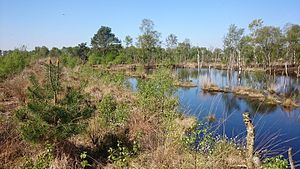
On the moor nature trail in the Molberger Dose (2016) |
||
| location | West of Molbergen , east of Lindern , Lower Saxony , Germany | |
| surface | 6 km² | |
| Identifier | NSG WE 192 | |
| WDPA ID | 164652 | |
| Geographical location | 52 ° 51 ' N , 7 ° 52' E | |
|
|
||
| Sea level | from 32 m to 39 m | |
| Setup date | December 31, 1988 | |
| administration | NLWKN | |
The Molberger Dose is a nature reserve in the Lower Saxony communities of Molbergen and Lindern in the district of Cloppenburg .
The nature reserve with the sign NSG WE 192 is 600 hectares in size. It has been a nature reserve since December 31, 1988. The responsible lower nature conservation authority is the district of Cloppenburg.
The nature reserve is a raised bog in the form of a boiler bog . In the eastern part of the nature reserve there is a 2.94 km long educational moor trail , which is designed as a circular route. Explanations on the subject of bog are given at ten stations along the way.
See also
literature
- H. von der Wall: The "can" near Molbergen. Report on a peatland survey . In: Home calendar for the Oldenburger Münsterland . Vol. 13, 1964. pp. 46-52 ( online )
- Gabriele Schröder: Mohr educational trail “Molberger Dose” . In: Yearbook for the Oldenburger Münsterland 1995 . Vechta 1994, pp. 287-291
- Gerhard Weyrauch: Insects and spiders in the “Molberger Dose” nature reserve . In: Yearbook for the Oldenburger Münsterland 2014 . Vechta 2013, pp. 244–262
Web links
Commons : Molberger Dose - collection of images, videos and audio files


