Þjórsá
|
Þjórsá Thjorsa |
||
|
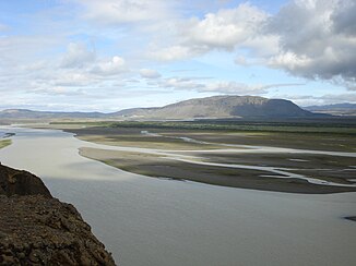
Þjórsá at the height of the Hekla, view of the Búrfell |
||
| Data | ||
| location | Iceland | |
| River system | Þjórsá | |
| source |
Hofsjökull 64 ° 49 ′ 0 ″ N , 18 ° 49 ′ 23 ″ W. |
|
| muzzle | In the Atlantic Ocean coordinates: 63 ° 47 ′ 0 ″ N , 20 ° 48 ′ 0 ″ W 63 ° 47 ′ 0 ″ N , 20 ° 48 ′ 0 ″ W |
|
| Mouth height |
0 m
|
|
| length | 230 km | |
| Catchment area | 7530 km² | |
| Drain |
NNQ (1963) HHQ (1948, 1949) |
20 m³ / s 3000 m³ / s |
| Left tributaries | Tungnaá | |
| Reservoirs flowed through | Sultartangalón | |
| Waterfalls: Urriðafoss , Tröllkonuhlaup | ||
|
Þjórsárver, headwaters of the river at the foot of Hofsjökull |
||
The Þjórsá ( Icelandic pronunciation [ θjour̥sau ], German transcription Thjorsa ) is a river in southern Iceland . At 230 km, it is the longest river on the island. The catchment area of the zugsjórsá covers 7,530 km² or 7.2% of the total surface of Iceland. Near the mouth of the Urriðafoss waterfall , the average amount of water in summer is 350–700 m³ / sec.
Surname
About the name of the river it says in the land registry : “órarinn was the name of a man, the son of Þorkell ... He came with his ship into the Þjórsárós (that is the mouth of the Þjórsá). He had a cow's head on the bow and that's what the river is named for. "( Altisl. Þjór " cow ")
Headwaters
The Þjórsá rises on the Hofsjökull glacier mainly at the Þjórsárjökull glacier tongue , where the river Bergvatnskvísl is called Þjórsár , often just Bergvatnskvísl . But it also draws water from springs near the Þjórsárdrög and from a well-known nature reserve, a moor area with springs called Þjórsárver . The river is named jórsá from the place where the streams Háöldakvísl and Fjórðungskvísl from Tungnafellsjökull flow into it.
course
The main direction of flow follows the alignment of the rift zone from northeast to southwest.
The Þjórsá makes its way partly through narrow gorges over the Icelandic highlands . In doing so, she falls over several waterfalls. The total gradient here, roughly at the height of the Hekla, is 280 m for 40 km. The enormous energy of the river and its tributaries such as the Tungnaá have been used here in some power stations. The Tungnaá, for example, now flows into the Þjórsá in a reservoir, Sultartangalón . The Búrfell power plant uses the power primarily at the Tröllkónuhlaup waterfall , which has now almost dried up because part of the water is allowed to flow in channels through the Búrfell mountain , where the water power drives the turbines in a turbine house on the other side. In 2012 another power plant was under construction at Búðarháls.
Later, after taking up the Tungnaá tributary near the historic Stöng farm (see also Háifoss ), the Þjórsá flows into the plain and broadly over various lava fields, etc. a. that 8,000 years as Tungnaárhraun, then.
After that, it branches out more frequently and forms small islands. In the middle of the river is the island of Árnes , which used to be a headland. There is an old thing site on it . The Árnessýsla district is named after the island .
Between Selfoss and Hella , above the Urriðafoss waterfall, the ring road ( Hringvegur ) crosses the river on a bridge, which flows into the sea a few kilometers southwest of it.
Floods and droughts
The Þjórsá is prone to significant flooding. It even causes the largest in the country, apart from the glacier runs .
The largest tidal waves measured so far in the Þjórsá were over 3,000 m³ / sec. in 1948 and 1949.
Flooding can also be due to the enormous ice formation in some winters. This was the case around winter 2006/2007. In doing so, ice barriers form on bridges, for example, which accumulate the water behind them and thus trigger flooding. Such phenomena are not uncommon in other rivers in Iceland in winter, such as the Hvítá in Borgarfjörður . Farm residents can become island residents.
However, periods of drought have also been identified. Their average amount of water was reduced to just 20 m³ / sec. in April 1963.
Glacial river
For the most part, the Þjórsá is a glacial river . It also flows over long stretches of desert erosion in the highlands. This means that it carries large amounts of sediment with it.
Traffic obstruction
In the past the river was a significant obstacle to traffic. This is still the case today in the highlands, where there is only one practicable ford, Sóleyjarhöfðavað . If this cannot be done, people who are traveling in the highlands and have to cross over - for example, looking for sheep or hiking - cross the individual tributaries further north.
Boats used to be used to cross the river. Some ferry stations are known, such as Sandhólaferja, which was already used during the time of the conquest .
The first bridge over the river dates from 1895, it was renewed in 1949 and the ring road runs over it near the Urriðafoss waterfall. Another bridge is in the highlands near the power stations. The Sprengisandur highland slope begins here .
See also
Web links
- Thjorsa . Nat.is (English)
- Island in Þjórsá under nature protection, Vísir (Icelandic)


