Tomato islands
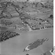
The tomato islands are located on the right bank of the Upper Rhine between Rhine kilometers 349 and 350. The islands belong to Au am Rhein , the northernmost municipality in the Baden-Württemberg district of Rastatt . Opposite the islands is the entrance to the port of the Alsatian town of Lauterbourg .
In the area of the tomato islands, the Rhine was straightened according to plans by Johann Gottfried Tulla between the 1820s and 1860s. Since then, the Rhine has been running in a tight right curve at this point. The Illingen Old Rhine flows into the inside of the arch . The Kohlkopf headland is located between the Rhine and the Old Rhine ; its northern tip is also known as the Auer Köpfle . The Fahrkopf lies north of the Old Rhine . The district road 3724 coming from Au am Rhein ends here . The name Fahrkopf refers to the earlier ferry to Lauterbourg, which is documented for the 18th century. Between 1875 and 1898, the Baden government rejected the construction of a ship bridge from Fahrkopf to Lauterbourg several times , in 1898 on the grounds that the costs were disproportionate to the benefits for Baden . In November 1918, the ferry service, which had last been barely profitable, was stopped.
When the Rhine was regulated between Sondernheim and Strasbourg from 1907, which was supposed to enable navigation even when the water was low , groynes were built on the right bank of the Rhine . On the sliding slope of the Rhine curve, islands naturally formed due to continuous gravel deposits , for which the name tomato islands became established because tomatoes grew here at low water levels . Tomato seeds are not digested by humans and get into the Rhine via sewage .
A topographic map from the middle of the 20th century shows two islands a good 200 meters long and 60 and 40 meters wide. The upper island at the level of the mouth of the Old Rhine was overgrown with bushes. Islands and landings are also shown in topographic maps that were published later .
In 1990 the nature reserve " Auer Köpfle-Illinger Altrhein-Motherner Wörth " was designated. It covers areas south of the county road. A 1986 appraisal of these areas describes an adjacent Rhine island on the Auer Köpfle, the higher parts of which were overgrown with willows, poplars and reeds. At the edge there were fast-growing, bushy types of willow such as purple , wicker or almond willow , in whose flow protection white willow and black poplar grew. The island was one of the last natural breeding grounds for the little ringed plover and riverside sandpiper , which had numerous gravel areas before the Rhine was straightened out. It was also used by migrants such as ruff , redshank and wood sandpiper as a resting and sleeping place. In the 1980s, the Waterways and Shipping Directorate had the trees on the island removed as they were a visual obstacle for shipping. The island shrank through the clearing; the landings increased downstream.
As of October 2014, the tomato islands were redesigned for around two million euros. The construction work was part of a conservation project, partially funded by the EU -Förderprogramms LIFE + funded. A ditch was created at the Auer Köpfle, through which Rhine water is channeled into the Illingen Old Rhine. In addition, two gullies were created along the right bank of the Rhine, for which the existing groynes were divided. The resulting excavation was used to raise the islands. The construction work created three islands that offer gravel breeders areas that are safe from predators such as foxes . Gravelly soles are to be created in the channels, which are protected from the waves of the ships and are therefore suitable as spawning grounds for fish such as salmon , allis shad and lampreys . The newly designed islands were inaugurated on April 22, 2015 by the Karlsruhe District President Nicolette Kressl .
Web links
- Redesign of cabbage and tomato islands at www.rheinauen-rastatt.de.
Individual evidence
- ^ Alfred Weßbecher: Au on the Rhine. In: Landkreis Rastatt (Hrsg.): Heimatbuch Landkreis Rastatt. 1979 (6) pp. 59-74, here pp. 62-65.
- ↑ Naturschutzbund Deutschland eV (Ed.): Rheinstrandführer. Nature conservation and relaxation on the Rhine beach. 2010 (pdf, 1.8 MB).
- ^ A b Susanne Kutter, Volker Späth: Rheinauen. Threatened paradise on the Upper Rhine. G. Braun, Karlsruhe 1993, ISBN 3-7650-8076-4 , p. 114.
- ^ Service Géographique des FFA (Ed.): 7015 Durmersheim , 5th edition 1954 (digitized at Brigham Young University ).
-
↑ Landesvermessungsamt Baden-Württemberg (ed.): Topographische Karte 1: 25000 - 7015 Rheinstetten. 5th edition. Stuttgart 1997, ISBN 3-89021-078-3 ;
W. Schweinfurth, H. Klüver: Au am Rhein - natural space and settlement. In: Landesarchivdirektion Baden-Württemberg (ed.): The district of Rastatt. Volume 1, Thorbecke, Stuttgart 2002, ISBN 3-7995-1364-7 , pp. 343-347; here p. 343 f. -
↑ Appreciation NSG Auer Köpfle-Illinger Altrhein-Motherner Wörth , section Die Rheininsel am Auer Köpfle (1986);
Reinholdreiber: Auer Köpfle - Illinger Altrhein - Motherner Wörth. In: District Office for Nature Conservation and Landscape Management Karlsruhe (Ed.): The nature reserves in the administrative district of Karlsruhe. Thorbecke, Stuttgart 2000, ISBN 3-7995-5172-7 , pp. 466-469. -
↑ Redesign of cabbage and tomato islands at www.rheinauen-rastatt.de (accessed on October 11, 2014);
Current information at www.rheinauen-rastatt.de (accessed on October 11, 2014);
LIFE + project “Rheinauen bei Rastatt”, measure C4, variant 5: Site plan with an overview of the measures. (pdf, 1.2 MB, accessed October 11, 2014). - ↑ LIFE + project “Rheinauen bei Rastatt” / Inauguration of the tomato islands. Press release Regional Council Karlsruhe, April 22, 2015 (accessed on August 30, 2015).
Coordinates: 48 ° 57 '27 " N , 8 ° 11' 55" E


