Uhelná (Hrádek nad Nisou)
| Uhelná | ||||
|---|---|---|---|---|
|
||||
| Basic data | ||||
| State : |
|
|||
| Region : | Liberecký kraj | |||
| District : | Liberec | |||
| Municipality : | Hrádek nad Nisou | |||
| Geographic location : | 50 ° 52 ' N , 14 ° 54' E | |||
| Height: | 336 m nm | |||
| Residents : | 33 (March 1, 2001) | |||
| Postal code : | 463 34 | |||
| License plate : | L. | |||
| traffic | ||||
| Street: | Václavice - Uhelná | |||
Uhelná ( German Kohlige ) is a district of the city of Hrádek nad Nisou in the Czech Republic . It is located four kilometers northeast of Hrádek nad Nisou on the border with Poland and belongs to the Okres Liberec .
geography
Uhelná is located on the Vřesový vrch ( Heideberg , 341 m) directly on the Polish border. A large sand pit is operated southeast of the village. In the south lies the valley of the Václavický potok ( Grafensteiner Bach ). The Ślad ( Schladebach ) rises to the east and the Oldřichovský potok ( Ullersdorfer Bach ) to the west .
Neighboring towns are Białopole in the north, Opolno Zdrój in the north-east, Jasna Góra and Horní Vítkov in the east, Václavice in the south, Grabštejn and Hrádek nad Nisou in the south-west, Oldřichov na Hranicích in the west as well as the bush farm in the north-west.
history
Kohlige was established in 1720 as a charcoal burner settlement in the Dominikal forests of the Grafenstein domain . In 1830 the place consisted of 30 houses and had 170 inhabitants. The road from Grottau led via Kohlige to the important Saxon spa town of Bad Oppelsdorf and there was a customs office at the border. Another crossing led to the northern Sommerau .
After the abolition of patrimonial Kohlige formed from 1850 a district of the political community Wetzwalde in the district administration Reichenberg and the judicial district Kratzau . During the German War , the Prussians marched on the border in the evening on June 22, 1866, provoked and shot a Radetzky hussar. A week later they marched into Bohemia. 450 officers, 3892 soldiers and 366 horses were quartered in the village consisting of 34 houses. Another warehouse was set up in the upper village of Wetzwalde.
In 1869 there were 193 people living in Kohlige, in 1900 there were 185. The population fell continuously and in 1930 Kohlige only had 169 inhabitants. After the Munich Agreement , Kohlige was added to the German Reich in 1938 and belonged to the Reichenberg district until 1945 . After the end of World War II, the village came back to Czechoslovakia and the German residents were evicted until 1946. In 1946 Kohlige was renamed Uhelná. The border that now ran to Poland was closed. In 1950 the village had 83 inhabitants and in 1970 there were 53. Together with Václavice, Uhelná was incorporated into Hrádek nad Nisou in 1980. The low point of the population decline was reached in 1991 when only 18 people were registered as permanent residents in Uhelná. In 2001 the village consisted of 13 houses in which 33 people lived.
Local division
Uhelná belongs to the Václavice cadastral district.
Attractions
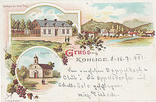
- Chapel of the Helpful Virgin Mary, built in 1867, the ruined chapel was restored in 2017
- Scholze-Mühle, former windmill, southeast of the village
- Spálena lípa, tree monument, southeast of the village


