Uthlande


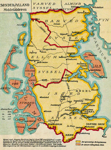
Under Uthlande or Utlande ( Low German or altdänisch for foreign country , the Danish also: Friselag (s) ) refers to the upstream to the mainland foreign country (islands, islets and marshes) in what is now North Friesland .
history
The name is first documented for the 12th century. The islands of that time differed significantly from the mainland both in their political status and in their social composition. Today, part of the former Uthlande has sunk into the sea (especially a large part of the island of Strand ) and has become part of the mainland partly through dykes and land reclamation . The name probably goes back to the East Danish language of the office in Lund in Skåne , which was still Danish at the time .
The Harden were later the largest administrative district on the Danish mainland . They consisted of several parishes . On the Jutland mainland there was still Syssel , which combined several Harden, but was completely missing in the Uthlanden. The Frisians became direct subjects of the Danish king ("Königsfriesen") and fought for him in the battles with the Holy Roman Empire and the Holsteiners . In the Middle Ages, however, they managed to obtain extensive autonomy. They were exempt from Jydske Lov , issued in 1241, and were allowed to continue to judge according to Frisian law (see also Lex Frisionum , Siebenhardenbelieben , Crown of Right Truth ).
Than 1250 King Erik IV. Of Denmark tried in the Uthlanden the Plogpennig collecting the VAT a penny on every plow, he had to leave the area finally fled after many Danish knights had lost their lives there. His brother, murderer and successor Abel lost most of his army and his life when he tried again in 1252 to collect taxes.
In 1261 the Hanseatic City of Hamburg signed a peace treaty with the Frisians in Utlandia ; whether this only refers to the three Harden Eiderstedter or the whole of Uthland is not clear from the document. By 1284 the central power had solidified so much that Duke Waldemar IV of Schleswig was able to conclude a binding contract with the Hanseatic City of Bremen on behalf of the Frisians .
Harden the Uthlande
In the Middle Ages the following Harden belonged to the Uthlands:
- Bökingharde , today the mainland
- Horsbüllharde ( Wiedingharde ), today mainland
- Föhr Osterharde (the east of the island of Föhr ), still island
- Föhr Westerharde ( Amrum and the west of Föhr), still an island
- Sylt ( Sylt )
- Wiriksharde (formerly part of the island of Strand , for example the area around Hallig Langeneß ), united with the Beltringharde in the 16th century and largely sunk in the sea in 1634
- Beltringharde (northeast part of the island of Strand), mostly sunk in the sea
- Pellwormharde (southwest part of the island of Strand, around today's Pellworm ), partly sunk in the sea
- Edomsharde (southern part of the island of Strand including the submerged Rungholts ), mostly submerged in the sea except for today's peninsula Nordstrand
- Lundenbergharde (southeast part of the island of Strand, about the area of today's Simonsberg ), remnants are now mainland
- Eiderstedt (eastern part of today's Eiderstedt ), today peninsula
- Everschop (northwestern part of today's Eiderstedt with Westerhever , then an island), now a peninsula
- Utholm (southwest part of today's Eiderstedt with St. Peter-Ording , then an island), today a peninsula.
The list of areas varies by source and year. The shape of the coast has changed a lot over the centuries. Important sources are Waldemar II's earth book , created around 1230, and historicizing maps by Johannes Mejer (printed in 1652). In the earth book there is a separate record of all inhabited islands on the west coast. The three names listed there, Gaestaenacka , Hwaelae major and Hwaelae minor , can no longer be found or proven as islands today. The often-expressed assumption that these were located west of Alt-Nordstrand and sank into the sea during storm surges up to the 14th century, is doubted: These three names may be the product of transcription errors that the writer at the time when transferring the names DeStrandt , Eydaerstath and Hewerschop are undermined.
Uthlande region
On March 26, 2002, the association Regional Partnership Uthlande eV was founded, which has set itself the goal of promoting the "Region Uthlande", which encompasses the islands and Halligen in North Friesland.
Others
The Dresden - Westerland intercity train pair operates under the name Uthlande , and several ships have also carried this name.
See also
literature
- Christian Peter Hansen : Chronicle of the Frisian Uthlande . 2nd Edition. 1877 ( limited preview in Google Book Search - limited preview of the reprint of BiblioBazaar 2008).
- Nicolas Peters, Mathias Peters: Kaart van Noord-Friesland in Sleeswijk (Duitsland) in 1651 (left) en 1240 (right) . Historical map from the holdings of the Nederlands Scheepvaartmuseum , Amsterdam. Husum 1664 ( gougenvannederland.nl [accessed on May 24, 2010] Dutch: FRISIA BOREALIS IN DVCATV SLESWICENSI sive FRISIA CIMBRICA Anno 1651; FRISIA BOREALIS IN DVCATV SLESWICENSI Anno 1240. Frisia Cimbrica Antiqu .).
- G. Schernewski, T. Dolch (Ed.): Geography of the seas and coasts, Coastline Reports 1 (2004) . 2004, ISSN 0928-2734 .
Web links
Individual evidence
- ^ Adolf Ditlev Jørgensen: Bidrag til nordens historie i middelalderen. København 1871, p. 35.
- ↑ See Wolfgang Laur : Historisches Ortnamelexikon von Schleswig-Holstein. 2nd edition, Neumünster 1992, p. 666.
- ^ Hanswilhelm Haefs: Place names and local stories in Schleswig-Holstein , Norderstedt 2014, ISBN 3-8334-0509-0 , page 227
- ↑ Jürgen Newig: The coastal shape of North Friesland in the Middle Ages according to historical sources (PDF; 1.3 MB) In: Geographie der Meere und Coasts, Coastline Reports 1 (2004), pp. 23-36, with a graphical representation of the error sequence. Retrieved October 21, 2010
- ↑ Train direction sign


