Uttewalde
Uttewalde is a small village on the north-western edge of Saxon Switzerland . The village has been part of the Lohmen community since 1961 .
Location and type of settlement
Uttewalde is located approx. 3 kilometers southeast of Lohmen at an altitude of approx. 250 meters above sea level on the edge of a plateau (Lohmen flatness) west of the Uttewalder Grund . The development of the village is grouped around a short but deep cut into the terrain that leads to the Uttewalder Grund. In terms of the type of settlement, it is a forest hoof village , although the parcels of the village are arranged irregularly and more like a round shape.
The district of Uttewalde also includes a few houses from the Hohle expansion on the south-eastern outskirts of Lohmen.
history
Uttewalde was probably founded in the 14th century as part of the general German settlement in the east . It was first mentioned in a document around 1400 as Ottenbalde . The name indicates a village owned by Otto as a locator . Other forms of name are recorded as Ottenwalde (1445), Ottewalt (1464) and Uttenwalde (1547). At the end of the 18th century, the name Ottewalde was also used in addition to the current name .
The village originally belonged to the domain of the Wehlen rule in the vicinity of Wehlen Castle . Along with Wehlen Castle, Uttewalde also came into the direct possession of the Saxon Elector Johann Friedrich I in 1543. In administrative terms, Uttewalde was now under the electoral administration in Lohmen.
Ecclesiastically, Uttewalde was assigned to the neighboring village of Wehlen , and Uttewalde never had its own church.
For centuries, the economic basis of Uttwald was agriculture, although in earlier times fruit and hops were also grown to a small extent . In addition, some of the residents worked in the management of the surrounding forests and in the nearby sandstone quarries in Saxon Switzerland, especially in the White Quarries in the Elbe Valley between Wehlen and Rathen.
In the course of the tourist development of Saxon Switzerland, which began at the end of the 18th century, tourism also gained in importance. Until the completion of the Elbe Valley Railway (1851), Uttewalde was on the main access route to Saxon Switzerland, which led from Pillnitz via Graupa , the Liebethaler Grund and Lohmen to Uttewalde. From here the path continued over the Uttewalder Grund to the bastion . Today in Uttewalde there is an inn with a guesthouse, several holiday apartments and an inn in Uttewalder Grund.
The majority of the residents work in the surrounding towns (including Lohmen, Pirna).
On August 1, 1961, it was incorporated into Lohmen .
The fire of 1884
On September 11, 1884, a fire broke out in a barn in the village, which quickly spread across Uttewalde. The lack of water caused by the drought of the past few weeks encouraged the fire to spread, so that almost all of the buildings burned down in less than an hour. Apart from the Gasthor, only goods no. 8, no. 17 and no. 19 were spared. A three-year-old child was killed in the flames, 25 families with around 125 people became homeless.
Donations of money and material for the damaged families came to Uttewalde from all over Saxony. An aid committee founded for the reconstruction under the direction of the Pirna governor Albin Le Maistre was able to distribute almost 25,000 marks in donations at the end of 1884.
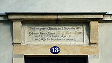
During the reconstruction, the buildings were not erected as half-timbered houses as before, but in massive stone construction. Inscription panels on several buildings remind of the fire disaster.
Size and population
- 1445: 8 possessed men and 3 gardeners
- 1547/51: 8 possessed men and 6 residents
- 1764: 13 possessed men and 4 cottagers
- 1821: about 24 houses with about 140 inhabitants
- 1834: 137 inhabitants
- 1871: 190 inhabitants
- 1890: 255 inhabitants
- 1910: 223 inhabitants
- 1925: 211 inhabitants
- 1939: 171 inhabitants
- 1946: 210 inhabitants
- 1950: 201 inhabitants
traffic
The traffic development takes place via the district road K8712, which connects Uttewalde to the district road K8711 from Lohmen to Dorf Wehlen.
The public transport connection is provided by the regional traffic Saxon Switzerland-Eastern Ore Mountains (RVSOE). On the hiking car park at the entrance to the village there is a stop for the Bastei-Kraxler, which runs between the Bastei and the city of Wehlen .
tourism
The Saxon Switzerland National Park borders directly on Uttewalde in the north, east and south and surrounds the village on three sides. Today the Malerweg , the main hiking trail of the Elbe Sandstone Mountains , leads through the neighboring Uttewalder Grund . A marked hiking trail leads through Uttewalde itself, which leads over two steep steps into the Uttewalder Grund.
Personalities
The Saxon dialect poet and local researcher Bruno Barthel (1885–1956) spent part of his childhood in Uttewalde.
literature
- Königstein area, Saxon Switzerland (= values of the German homeland . Volume 1). 1st edition. Akademie Verlag, Berlin 1957.
- Manfred Hickmann: Uttewalde in need - burned down and yet saved. in: Calendar Sächsische Heimat 2015
- Alfred Meiche : Historical-topographical description of the Pirna administration. Dresden 1927
Web links
Individual evidence
- ^ Lohmen Sachsen - districts Daube, Doberzeit, Mühlsdorf and Uttewalde. Retrieved February 25, 2017 .
Coordinates: 50 ° 58 ′ 36.7 ″ N , 14 ° 1 ′ 53.2 ″ E


