
Vatta
| Vatta | |||||
|
|||||
| Basic data | |||||
|---|---|---|---|---|---|
| State : | Hungary | ||||
| Region : | Northern Hungary | ||||
| County : | Borsod-Abaúj-Zemplén | ||||
| Small area until December 31, 2012 : | Mezőkövesd | ||||
| District since 1.1.2013 : | Mezőkövesd | ||||
| Coordinates : | 47 ° 55 ' N , 20 ° 44' E | ||||
| Height : | 123 m | ||||
| Area : | 23.37 km² | ||||
| Residents : | 873 (Jan. 1, 2011) | ||||
| Population density : | 37 inhabitants per km² | ||||
| Telephone code : | (+36) 49 | ||||
| Postal code : | 3431 | ||||
| KSH kódja: | 30076 | ||||
| Structure and administration (status: 2018) | |||||
| Community type : | local community | ||||
| Mayor : | István Attila Korán (Fidesz-KDNP) | ||||
| Postal address : | Szemere Bertalan u. 20. 3431 Vatta |
||||
| Website : | |||||
| (Source: A Magyar Köztársaság helységnévkönyve 2011. január 1st at Központi statisztikai hivatal ) | |||||


Dada is a Hungarian community in the county Mezőkövesd in Borsod-Abaúj-Zemplén .
Geographical location
Vatta is located in northern Hungary , a good 20 kilometers south of the Miskolc county seat , on the small river Csincse-patak . Neighboring communities are Harsány , Borsodgeszt , Csincse , Emőd and Bükkábrány .
Parish partnership
-
 Karatschyn (Карачин), Ukraine , since 2017
Sons and daughters of the church
- Bertalan Szemere (1812–1869), writer and politician
- Viktor Padányi (1906–1963), historian, linguist and writer
Attractions
- Bertalan Szemere memorial column, created in 1974 by Gábor Gáti
- Reformed Church, built in the 1810s
- Roman Catholic Church Szeplőtelen Fogantatás , built 1759–1765 (late baroque)
- Odescalchi Castle ( Odescalchi-kastély ), built in the 18th century
- World War I monument (I. és II. Világháborús emlékmű), created in 1926 by János Pásztor
traffic
Main road no.3 runs through Vatta . The nearest train stations are in Csincse and Emőd.
photos
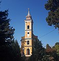
Roman Catholic Church Szeplőtelen Fogantatás

Dirt road from Harsány to Vatta

View of Odescalchi Castle


literature
- Vatta - Településképi Arculati Kézikönyv. Ed. By the municipal administration, Vatta 2017.
Web links
- Official website (Hungarian)
- Vatta at tourinform
- A vattai református templom (Hungarian)
- Aerial views over Vatta