
Szomolya
| Szomolya | |||||
|
|||||
| Basic data | |||||
|---|---|---|---|---|---|
| State : | Hungary | ||||
| Region : | Northern Hungary | ||||
| County : | Borsod-Abaúj-Zemplén | ||||
| Small area until December 31, 2012 : | Mezőkövesd | ||||
| District since 1.1.2013 : | Mezőkövesd | ||||
| Coordinates : | 47 ° 53 ' N , 20 ° 30' E | ||||
| Height : | 188 m | ||||
| Area : | 22.69 km² | ||||
| Residents : | 1,572 (Jan 1, 2011) | ||||
| Population density : | 69 inhabitants per km² | ||||
| Telephone code : | (+36) 49 | ||||
| Postal code : | 3411 | ||||
| KSH kódja: | 18892 | ||||
| Structure and administration (as of 2020) | |||||
| Community type : | local community | ||||
| Mayoress : | Györgyné Jurecska (Fidesz-KDNP) | ||||
| Postal address : | Szabadság tér 1. 3411 Szomolya |
||||
| Website : | |||||
| (Source: A Magyar Köztársaság helységnévkönyve 2011. január 1st at Központi statisztikai hivatal ) | |||||


Szomolya is a Hungarian community in the county Mezőkövesd in Borsod-Abaúj-Zemplén .
Geographical location
Szomolya is located in northern Hungary , 48 kilometers southwest of the Miskolc county seat . The next town Mezőkövesd is about 12 kilometers south of Szomolya.
Attractions
- Kisboldogasszony Roman Catholic Church , built in 1898 (neo-baroque)
traffic
Road No. 2509 runs through Szomolya. The nearest train station is in the southeast in Mezőkövesd.
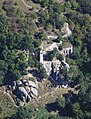
photos

Aerial photos:
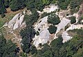
Cave settlement on the outskirts of Szomolya


Individual evidence
- ^ Borsod-Abaúj-Zemplén megye polgármestereinek névsora. BOON, October 14, 2019, accessed February 29, 2020 (Hungarian).