
Volkhoven / hamlet
|
district 608 of Cologne |
|
|---|---|
 |
|
| Coordinates | 51 ° 1 '24 " N , 6 ° 52' 53" E |
| surface | 4.353 km² |
| Residents | 6081 (December 31, 2017) |
| Population density | 1397 inhabitants / km² |
| Incorporation | Apr 1, 1888 (Volkhoven) Apr 1, 1922 (Weiler) |
| Post Code | 50765 |
| prefix | 0221 |
| Borough | Chorweiler (6) |
| Transport links | |
| Railway lines | S 6 S 11 |
| Bus routes | 121 125 126 |
| Source: 2017 residents . (PDF) Cologne district information | |
Volkhoven / Weiler is a district in the north of Cologne on the left bank of the Rhine.
location
The neighboring districts are (clockwise from the north): Roggendorf / Thenhoven , Blumenberg , Chorweiler , Heimersdorf , Lindweiler and Esch / Auweiler . The Volkhoven / Weiler district is part of the Chorweiler district .
history
As the double name suggests, the district originally consists of two small villages that grew together in the 20th century. Volkhoven , located to the south, belonged to the canton of Weiden during the French era and was incorporated into Cologne in 1888 as part of the Longerich mayor . The northern hamlet belonged to the mayor of Worringen and was incorporated with this in 1922. Both villages were shaped by the large courtyards that are still there today. The old parish church, built in 1766, is also located in the old town center of Weiler.
A small settlement was established between the two villages in the mid-1920s. The new parish church of St. Cosmas and Damian was built in 1925 .
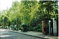
Also in 1925, the city of Cologne built a new waterworks in a forest area north of the district . After some extensions and modernizations, this still secures a large part of Cologne's drinking water supply on the left bank of the Rhine . The water body of the groundwater is filled by the renatured Pulheimer Bach , which seeps into the nature reserve of the small and large Laache about 3 km beforehand. It is of better quality than the usual bank filtrate. The water protection area is connected to the Ville ( Glessener Höhe ) and the Rhineland Nature Park via the green corridor northwest of the Rhine and its oxbow lakes via the Pulheimer Bach adventure and educational trail .
In 1964 there was a rampage with a flame thrower at the elementary school ( Volkhoven assassination ) with ten dead.
In the 1970s, Volkhoven / Weiler fell into the shadow of the newly built satellite town of Chorweiler to the east . This led to an improvement in the traffic development: Immediately to the south there is a motorway feeder that leads to the Cologne-North motorway junction. A four-lane access road connected to this leads past Volkhoven / Weiler to the east.
A S-Bahn line was laid next to the motorway feeder. From the Köln-Volkhovener Weg stop you can take the S 6 and S 11 trains to reach Cologne Central Station in around 15 minutes. In the other direction, line S 11 leads via Dormagen and Neuss to Düsseldorf .
The railway line from Cologne via Neuss to Krefeld has been located west of the district for over 150 years . A temporary stop in Weiler has not been in operation for a long time.
Beyond this railway line, a large cemetery was opened for the districts of Seeberg, Heimersdorf, Chorweiler, Blumenberg and Lindweiler at the end of the 1960s.
Demographic statistics
Structure of the population of Cologne-Volkhoven / Weiler:
- Proportion of under 18-year-olds: 20.8% (2015)
- Proportion of over 64-year-olds: 12.7% (2015)
- Proportion of foreigners: 19.7% (2015)
- Unemployment rate: 9.4% (2014)
Public facilities
Because of the good traffic connections, the only police station of the professional fire brigade for the borough of Chorweiler was built on the outskirts . Adjacent to the north is the building of the Federal Office for the Protection of the Constitution , which moved from Cologne-Ehrenfeld to Volkhoven / Weiler at the end of the 1980s .
The only grammar school for the whole area of the satellite town is in Volkhoven.
The simultaneous hall is remarkable : in the schoolyard of the former Volkhovener village school, which was closed as a result of the 1964 attack , a provisional segment of the planned new building for the Museum Ludwig was built in the 1970s . Here the effect of the incidence of light on the pictures in the museum was tried out. After the end of these attempts, the hall was left to local artists as a studio and exhibition hall.
photos

Waterworks hamlet
Waterworks hamlet, pipes

Hamlet waterworks, steel filter fountain
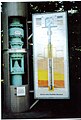
Hamlet waterworks, steel filter fountain, demonstration


See also
literature
- Paul Clemen: Die Kunstdenkmäler der Rheinprovinz, Vol. 4 Der Landkreis Köln , Düsseldorf 1897, Reprint Düsseldorf 1983, ISBN 3-590-32118-0 , p. 193
Web links
- Official website of the city of Cologne for the Volkhoven / Weiler district
- Website of the Citizens' Association Cologne-Volkhoven-Weiler eV
Individual evidence
- ↑ Inhabitants according to selected age groups - data source: City of Cologne - offenedaten-koeln.de
- ↑ Inhabitants according to selected age groups - data source: City of Cologne - offenedaten-koeln.de
- ↑ Inhabitants by type of migration background - data source: City of Cologne - offenedaten-koeln.de
- ↑ Employed and unemployed part of the city - data source: City of Cologne - offenedaten-koeln.de