Vulcano Laziale
| Vulcano Laziale | ||
|---|---|---|
|
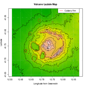
digital elevation model of the Vulcano Laziale |
||
| height | 956 m slm | |
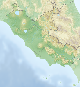
| location | Italy ( Lazio ) | |
| Coordinates | 41 ° 45 '22 " N , 12 ° 43' 31" E | |
|
|
||
| Age of the rock | Middle Pleistocene to Holocene | |
| Last eruption | 5000 years ago | |
| particularities | geological structure that forms the base of the Albanian Mountains | |
The Vulcano Laziale ( Latium Volcano ) is the geological structure on which the Albanian Mountains are based . Today this region is also known as Castelli Romani .
This large volcano was formed when liquid magma collected in an underground of ancient marine carbonate sediments that forms a wide plain between the coast and the Apennines .
It is believed that this volcano ejected about 297 km³ of volcanic material, 90% of which in the first eruptive phase. The latest studies by Funiciello et al. in 2002 about the recent activities of the crater on Lake Albano confirm that there was volcanic activity until around 5000 years ago, floods and lahars that emanated from the lake until the 4th century BC.
Today there is still discrete volcanic activity in this region, consisting of gas leaks, earth moving and frequent seismic activity (rarely severe and destructive as in 1438, 1806, 1829, 1899 and 1927).
This leads to the Vulcano Laziale being classified as dormant.
The fact that the volcano is dormant and has dormant phases between the eruptive phases of 30,000 to 40,000 years gives rise to fears that a future eruptive phase represents a great danger for the metropolitan area of Rome and for the region of the Alban Hills .
geology
The geological history of the Vulcano Laziale is divided into three periods or "phases" in the geological studies.
First phase or “Tuscolano Artemisio” phase
In this first phase, the structure of the volcano was formed, characterized by large explosions as well as pyroclastic and lava flows , interrupted by long periods of rest and the formation of accumulations of first volcanic products (gray coarse tuffs ) over marine and continental gravel and sands that make up the plain between the mountains and the coast. The accumulation of the lavas, which also reached the area of the future Rome, and the other volcanic ejection products such as lapilli , ash and cinder formed a large cone, which has a diameter of 60 km at its base.
This phase is divided into four cycles, which are interrupted by periods of rest with paleo-soil formation :
- First cycle: small-grain lithic tuff.
- Second cycle: Black Pozzolane .
- Third cycle: red pozzolans.
- Fourth cycle: Tufo Lionato, Tufo di Villa Senni.
The first phase ends about 360,000 years ago. Today the caldera of this phase of activity forms a wide "wall" of hills, which stretches in the shape of a horseshoe from Monte Tuscolo to Monte Artemisio (also the outer wall or the Tuscolano-Artemisio wall), and rises from just over 700 m above sea level. M. up to 939 m above sea level. M. on Monte Peschio . In ancient times, the Via Latina led through the deep cut at Cava d'Aglio of the outer rampart known as Mons Algidus . This topographical situation played an important role in Rome's disputes with the Aequern and Volscores , which was mentioned several times by ancient writers.
Second phase or “Delle Faete” phase or “dei Campi di Annibale” phase
In this second phase, starting about 280,000 years ago, a new volcano was formed, smaller in the center than the previous one, the Maschio delle Faete volcanic complex , the main activity of which took place in a caldera 15 km in diameter. In parallel, there was significant volcanic activity due to large lava flows from the side craters formed along fractures: they are the origin of the northern zone of the Vulcano Laziale.
After a relatively dormant period, volcanic activity occurred again along faults in the caldera of the "Tuscolano-Artemisio" phase, first in the lower zones, later in the high areas, with the formation of cinder cones and lava flows (e.g. the cone of Monte Ceraso or Monte Cavo). After this phase of activity, there was a period of rest 260,000 years ago, during which the main chimney cooled down and was clogged by a plug of consolidated, cooled volcanic rock.
Third phase or “Via dei Laghi” phase
This phase covers the period between 200,000 and 19,000 years before our time or continues today; it is also referred to as the "hydromagmatic" phase, as it is characterized by the underground meeting of water and the magma of the volcano. The rising magma meets groundwater at a depth of several hundred meters. The water of this deep groundwater body ( phreatic water), heated by the hot magma, forms large amounts of volatile gases that create a great pressure potential and look for ways to dissipate this energy. As soon as the pressure of the gases exceeds the strength of the surrounding rock, it is "pulverized" and the gases gradually rise to the surface.
After rising from a depth of several kilometers, the gases near the surface destroyed the rock by suddenly releasing pressure ( phreatomagmatic explosion ). This led to the formation of a mixture of water vapor and small rock debris, which then solidified and formed the peperin deposits known today . The distribution and stratigraphy of these occurrences suggest a frequent occurrence of these phreatomagmatic explosions in the last phase of activity. This phase of activity is attributed to the formation of a new fault in the carbonate subsurface, which is revealed on the surface by the subsidence of the south-eastern zone along a line between Frascati and Velletri . After this phase, the activity of the volcanic cone of Monte Cavo subsided , while the smaller craters filled with water. The crater lakes that still exist today are Lake Albano and Lake Nemisee .
The majority of this basin was drained as early as the times of ancient Rome (e.g. Vallericcia ), others only later (around 1611 the Laghetto di Turno), and others silted up for natural reasons. The Pantano della Doganella is regionally known for the fact that it "appears and disappears" at irregular intervals.
The Vulcano Laziale today
The area of the Vulcano Laziale, today the Alban Hills , has a round shape. Starting from Albano , the edges of the old crater form a wide circle that leads through the municipal areas of Castel Gandolfo , Marino , Grottaferrata , Rocca Priora , Velletri and Genzano di Roma . To a large extent it belongs to the Castelli Romani region . Volcanic rocks are mined as building materials , for example tuff (for example in the area of Rocca di Papa , where the Campi d'Annibale extend in the extinct crater), peperin (especially between the localities of Marino and Albano), Pozzolan (especially in the Zones towards Rome) and the volcanic cone, from which paving stones made of phonolite are extracted .
Thanks to the mineral-rich volcanic fertile soils, wine is grown; the wines with the DOC label, such as the Frascati , Marino , Lanuvio and Velletri, are known . There are also numerous mineral springs in the area of the former caldera .
According to the INGV, the entire zone is considered to be moderately prone to earthquakes.
Individual evidence
- ^ A b Renato Funiciello et al .: L'attività recente del cratere del Lago Albano di Castelgandolfo . In: Rendiconti Lincei. Scienze Fisiche e Naturali . tape 13 , no. 3 , 2002, p. 113–143 , doi : 10.1007 / BF02904490 (Italian, full text [PDF; 2.5 MB ; accessed on March 31, 2019] English abstract: “The recent activity of the lake Albano (Castelgandolfo, Italy) maar”).
- ↑ Active volcanoes. Istituto Nazionale di Geofisica e Vulcanologia , accessed on March 31, 2019 (English, here: “Italian active volcanoes”).
- ^ Matteo Marini: Verso il risveglio il vulcano alle porte di Roma: “Ma ci vorranno mille anni”. In: Repubblica.it . October 31, 2016, accessed on March 31, 2019 (Italian, title translation: “The awakening of the volcano at the gates of Rome is approaching: 'But it will take a thousand years'”).
- ↑ Mark Prigg: 'Extinct' volcano on the outskirts of Rome is waking up: Scientists warn Colli Albani eruption could be 'as destructive as Mt. Vesuvius' (although it won't be for 1,000 years). In: MailOnline ( Daily Mail ). July 14, 2016, accessed April 14, 2019 .
- ^ Stephanie Pappas: 'Extinct' Vulcano Near Rome Rumbles to Life. In: Live Science. July 13, 2016, accessed April 14, 2019 .
- ↑ Erik Klemetti: Could a Volcano Be Waking Up on the Outskirts of Rome? In: wired.com . July 13, 2016, accessed April 14, 2019 .
- ↑ Aerial photo of the Pantano della Doganella on Google Maps.
- ↑ Map of Vulcano Laziale with geological features and current place names on didascienze.it, accessed on March 31, 2019 (Italian).
literature
- Renato Funiciello, Guido Giordano: The Colli Albani Volcano (= Special publications of the International Association of Volcanology and Chemistry of the Earth's Interior . Volume 3 ). Geological Society of London , London 2010, ISBN 978-1-86239-307-3 ( limited preview in Google Book Search [accessed April 13, 2019]).
Web links
- Colli Albani in the Global Volcanism Program of the Smithsonian Institution (English).
- Sandra Zaccagnini: L'attuale conformazione del Vulcano Laziale. In: agroromano.net. Archived from the original on January 30, 2010 (Italian, "Current structure of the Vulcano Laziale", the three phases of activity).
- Site of the Natural Park of the Castelli Romani (Italian).
- Aldo Piombino: I Colli Albani: il rischio vulcanico in un apparato dormiente (The Alban Mountains: the volcanic risks in a sleeping apparatus), aldopiombino. blogspot.com , February 19, 2019


