
Wachwitzbach
| Wachwitzbach | ||
 Wachwitzbach (between Gönnsdorf and Wachwitz) |
||
| Data | ||
| location | Dresden | |
| River system | Elbe | |
| Drain over | Elbe → North Sea | |
| source | Gönnsdorf, northwest of the Am Park / Alte Dorfstrasse junction 51 ° 2 ′ 56 ″ N , 13 ° 51 ′ 56 ″ E |
|
| Source height | 285 m | |
| muzzle | in the Elbe coordinates: 51 ° 2 '12 " N , 13 ° 49' 51" E 51 ° 2 '12 " N , 13 ° 49' 51" E |
|
| Mouth height | 110 m | |
| Height difference | 148 m | |
| Bottom slope | 41 ‰ | |
| length | 3.6 km | |
| Catchment area | 2.8 km² | |
| Drain |
MNQ |
4 l / s |
| Left tributaries | Pappritzer Sumpfbach, Weg 7-Bach, Wachbergbach | |
| Right tributaries | Nordbach, Oberrochwitzer ditch, Oberrochwitzer ditch, Mittelrochwitzer ditch, Unterrochwitzer ditch | |
| Flowing lakes | Loschwitzbachteich, rock pond | |
 Mouth of the Oberrochwitz trench in the Wachwitzbach |
||
The Wachwitzbach is a tributary of the Elbe in the east of Dresden . It is named after the village of Wachwitz . Their name is derived from Slavic and means "village of the Vlach", that is, the leader of the settlers. The first houses in the settlement were built directly on the banks of the Elbe on the flood cone created by the Wachwitzbach.
course

The stream has its source in the Gönnsdorf district of Dresden . The source is located in the landscape park of the former Gönnsdorf manor and feeds two ponds next to the manor building. The stream first runs 300 meters to the west, then bends and flows in a south-westerly direction to the Elbe. After 3.6 kilometers of flowing, the stream flows orographically to the right into the Elbe southwest of Altwachwitz .
In the upper reaches, the stream is largely in a natural state until it reaches the development boundary in the Wachwitzgrund. Afterwards, the stream is paved almost entirely on both sides with bank walls and a paved base.
The course of the brook today corresponds to the historical course.
In the 2.8 square kilometer catchment area of the Wachwitzbach there are nine near-natural to partially natural seepage and linear springs: the Wachwitzgrund-Seitengrund springs 1 to 4, the Zachenrain spring, the Bartwiesen spring, the Gutten spring, the Lehnwiesen spring and the Wachberg spring. The land use in the catchment area is predominantly characterized by agriculture.
Water condition

Due to its catchment area of less than 10 square kilometers, the Wachwitzbach is not a separate body of water according to the European Water Framework Directive (WFD). The brook belongs to water body type 5 (WFD): "Coarse material rich, silicate low mountain brooks". The Wachwitzbach is an Elbhangbach with a steep slope. The headwaters mainly consist of substrates rich in coarse material such as blocks, stones and gravel. The geological subsoil is characterized by granodiorite and loess loam .
In the last investigation of the water quality of the Wachwitzbach in 2001/2002, the upper course of the creek showed only a low level of pollution (water quality I to II), but deteriorated in the course of the river to water quality class II (moderate pollution).
In the course of the Wachwitzbach there are four rainwater retention basins (two each in Gönnsdorf and Rochwitz ), which were put into operation between 1998 and 2004. In addition, rainwater is discharged at two points in Gönnsdorf. To the south-east of the Pappritzmühle, a debris trap and flotsam trap were set up in the stream.
natural reserve
The majority of the Wachwitzbach and its catchment area are located in the landscape protection areas of Schönfelder Hochland and Elbe slopes Dresden-Pirna and in the FFH area Elbe slopes between Loschwitz and Bonnewitz . Within the FFH area, the brook was completely mapped as a habitat type flowing water with underwater vegetation.
The following protected biotopes can be found at the Wachwitzbach: near-natural and natural flowing and standing inland waters with bank vegetation and floodplain areas, ravine forests and orchards . In addition, polluted willow stands are characteristic of the landscape in the upper water section . The Wachwitzbach is one of the most important habitats for the fire salamander in Dresden.
Cultural monuments on the Wachwitzbach
Gönnsdorfer Park

The Gönnsdorfer Park was built together with the neighboring manor in the French style in 1721, but was destroyed as early as 1760 during fighting in the Seven Years War . After the House of Wettin took over the manor in 1878, they partially redesigned the complex into an English landscape park .
Sycamore maple on the Wachwitzgrund

The sycamore maple on the Wachwitzgrund has been a natural monument since 1958 and was in very good condition until 1995. After the animals of a horse keeper ate the bark, he died. The tree is preserved as a natural monument because the deadwood is important to a wide variety of animals.
House of Hans Jüchser

The painter Hans Jüchser (1894–1977) lived in the Talhaus am Wachwitzbach from 1921 until the end of his life . Jüchser is one of the most important representatives of Dresden painting of the 20th century.
Cardboard mill

The paperboard mill, first mentioned in 1547, is located on Rochwitz's corridor. Milling came to an end in 1886 and the house has been used as a residential building ever since. From 1995 to 1997, the listed half-timbered building was completely renovated.
Historical events
Flood 1844
The worst known flood occurred on May 12, 1844 after a downpour. The creek developed into a raging body of water, causing landslides and shattering property walls, so that nine buildings were badly damaged and four completely destroyed. Two Wachwitz residents lost their lives.
A flood memorial stone next to the well house in Altwachwitz reminds of this event with the following inscription:
To commemorate the
thunderstorm that was devastating here on
May 12, 1844
.
Not only
do we want to entrust these stones to the memory of those
hours that were so ominous for us
,
also by giving
thanks to all those
who with their help
approached us generously
, whereby they set
a
permanent monument in our hearts, which stands more firmly,
than our
words entrusted to this perishable stone.
The
Commune Wachwitz
More floods
In the 1990s and 2000s, the Wachwitzbach in the Wachwitz location was expanded so that flood runoff can be safely discharged from a flood of the century . The danger of Verklausung to buildings in the local situation Wachwitz could be significantly reduced by the construction of a sediment catch.
Nevertheless, the Wachwitzbach Bridge on the Wachwitzgrund hiking trail was damaged in a flood in 2013 and had to be replaced by a new structure in 2015. The cost was around 45,000 euros.
gallery

Wachwitzbach shortly after leaving the source pond

Ford between Wachwitz and Rochwitz

Boulder catch
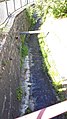
Wachwitzbach with embankment walls and a paved floor
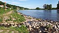
The Wachwitzbach flows into the Elbe


Web links
- Water profile (PDF; 526 kB), accessed September 10, 2017
Individual evidence
- ↑ A varied landscape with beautiful views . In: Dresdner Latest News . February 6, 2015 ( online , free of charge for users of the Dresden City Libraries [accessed on September 10, 2017]).
- ↑ A new bridge is being built in the Wachwitzgrund . In: Saxon newspaper . March 14, 2015 ( online , free of charge for users of the Dresden City Libraries [accessed on September 10, 2017]).