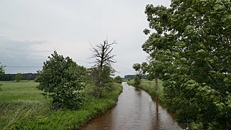
Wapel (Jade)
| Wapel | ||
|
The Wapel north of Jaderberg |
||
| Data | ||
| location | Lower Saxony , Germany | |
| River system | jade | |
| Drain over | Jade → Jade Bay → Inner Jade → Outer Jade → North Sea | |
| Beginning | between Grünenkamp and Conneforde 53 ° 19 ′ 54 ″ N , 8 ° 2 ′ 51 ″ E |
|
| Source height | 11 m above sea level NN | |
| muzzle | at Wapelersiel coordinates: 53 ° 22 ′ 7 ″ N , 8 ° 12 ′ 14 ″ E 53 ° 22 ′ 7 ″ N , 8 ° 12 ′ 14 ″ E |
|
| Mouth height | 0.1 m above sea level NN | |
| Height difference | 10.9 m | |
| Bottom slope | 0.87 ‰ | |
| length | 12.5 km | |
| Right tributaries | Dringenburger Bäke, Bekhauser Bäke | |
| Communities | Wapeldorf | |
The Wapel is a left-hand, western tributary of the Jade in northern Germany . It begins as a confluence of several ditches in the area of the settlements Grünenkamp , town of Varel , and Conneforde, municipality of Wiefelstede , on the border of the districts of Friesland and Ammerland . It flows in an easterly direction, crosses under the A 29 and flows into the Jade at Wapelersiel , which flows into the Jade Bay .
In addition to irrigation and drainage , the Wapel also serves as a fishing area. When the water level is right, it can also be used in canoes and kayaks .
In parts of its course, the Wapel forms the border between the district of Friesland in the north and the districts of Ammerland and Wesermarsch in the south.
In the 11th century, the Wapel (then also called Wepeling ) drained the south of the Frisian Gau Rüstringen up to its confluence with the Weser . This relationship was interrupted in 1219 by the First Marcellus Flood . At that time the tidal tube jade formed, in whose bed the current river jade runs.
Individual evidence
- ↑ Norbert Krebs (ed.): Country studies of Germany. Volume 1: The Northwest. 1931, p. 241.
