Watsontown
| Watsontown | ||
|---|---|---|
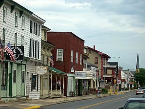
 Buildings on Main Street ( Pennsylvania Route 44 / Pennsylvania Route 405 ) in Watsontown |
||
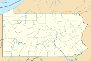
| Location in Pennsylvania | ||
|
|
||
| Basic data | ||
| Foundation : | 1794 (settled) 1858 (incorporated) |
|
| State : | United States | |
| State : | Pennsylvania | |
| County : | Northumberland County | |
| Coordinates : | 41 ° 5 ′ N , 76 ° 52 ′ W | |
| Time zone : | Eastern ( UTC − 5 / −4 ) | |
| Residents : | 2,255 (as of: 2000) | |
| Population density : | 1,252.8 inhabitants per km 2 | |
| Area : | 2.4 km 2 (approx. 1 mi 2 ) of which 1.8 km 2 (approx. 1 mi 2 ) is land |
|
| Height : | 146 m | |
| Postal code : | 17777 | |
| Area code : | +1 570 | |
| FIPS : | 42-81616 | |
| GNIS ID : | 1214021 | |
| Website : | www.watsontownpa.com | |
Watsontown is a borough in Northumberland County in the US state of Pennsylvania . At the time of the 2000 United States Census , Watsontown had a population of 2,254.
geography
Watsontown's geographic coordinates are 41 ° 5 ' N , 76 ° 52' W (41.085319, -76.863325). According to the United States Census Bureau , the borough has an area of 2.4 km 2 , of which 1.8 km 2 is land and 0.6 km 2 (= 24.47%) is water.
The west branch Susquehanna River forms the western city limits of Watsontown . The urban area is generally flat, only a mountain rises in the east. In addition to residential purposes, the area is used industrially to a small extent, and part of it is forested. Pennsylvania Route 44 and Pennsylvania Route 405 run through the place.
history
Land in the later area of Watsontown was first acquired by John Watson in 1792. A post office was opened in 1828. The railroad reached Watsontown in 1854, and a sawmill was built two years later. Until its incorporation in 1867 , Watsontown was part of the Turbot Township until its incorporation as a borough .
The Watsontown River Bridge was added to the National Register of Historic Places in 1988.
Demographics
| Population development | |||
|---|---|---|---|
| Census | Residents | ± in% | |
| 1870 | 1181 | - | |
| 1880 | 1481 | 25.4% | |
| 1890 | 2157 | 45.6% | |
| 1900 | 1898 | -12% | |
| 1910 | 1950 | 2.7% | |
| 1920 | 2153 | 10.4% | |
| 1930 | 2248 | 4.4% | |
| 1940 | 2282 | 1.5% | |
| 1950 | 2327 | 2% | |
| 1960 | 2431 | 4.5% | |
| 1970 | 2514 | 3.4% | |
| 1980 | 2366 | -5.9% | |
| 1990 | 2310 | -2.4% | |
| 2000 | 2255 | -2.4% | |
| 2010 | 2351 | 4.3% | |
| 2015 estimate | 2320 | -1.3% | |
| Sources: | |||
At the time of the United States Census 2000, Watsontown was inhabited by 2,254 people. The population density was 1,226.3 people per km 2 . There were 1,017 housing units, an average of 553.1 per km 2 . The population in Watsontown was 98.66% White , 0.40% Black or African American , 0.18% Native American , 0.13% Asian , 0.13% Pacific Islander , 0.09% said others Belonging to races and 0.40% named two or more races. 0.35% of the population declared to be Hispanic or Latinos of any race.
The residents of Watsontown were distributed across 967 households out of which 25.1% had children under the age of 18. 48.5% of households were married, 10.1% had a female head of household without a husband, and 38.8% were not families. 33.2% of households were made up of individuals and someone lived in 15.9% of all households aged 65 years or older. The average household size was 2.21 and the average family size was 2.81 people.
The population was divided into 21.1% minors, 7.2% 18–24 year olds, 27.3% 25–44 year olds, 23.1% 45–64 year olds and 21.3% aged 65 and over or more. The median age was 41 years. For every 100 women there were 79.3 men. For every 100 women over 18, there were 79.6 men.
The median household income in Watsontown was 31,094 US dollars and the median family income reached the amount of 37,065 US dollars. The median income for men was $ 30,648 versus $ 20,972 for women. The per capita income was $ 16,110. 11.2% of the population and 8.4% of families had an income below the poverty line , of which 15.7% of minors and 10.6% of those aged 65 and over were affected.
supporting documents
- ^ Watsontown Borough, Northumberland County 17777 ( English ) Retrieved October 18, 2016.
- ^ National Register Information System . In: National Register of Historic Places . National Park Service . Retrieved July 9, 2010.
- ↑ Annual Estimates of the Resident Population for Incorporated Places: April 1, 2010 to July 1, 2015 ( English ) Retrieved July 2, 2016.
- ^ Census of Population and Housing ( English ) US Census Bureau. Retrieved December 11, 2013.
- ↑ American FactFinder ( English ) United States Census Bureau . Retrieved January 31, 2008.
- ↑ Incorporated Places and Minor Civil Divisions Datasets: Subcounty Resident Population Estimates: April 1, 2010 to July 1, 2012 ( English ) In: Population Estimates . US Census Bureau. Retrieved December 11, 2013.
