Weißbach (Lattengebirge)
| Weissbach | ||
|
Torrent control on the Weißbach between Hochplatte and Lattenberg |
||
| Data | ||
| Water code | DE : 186678 | |
| River system | Danube | |
| Drain over | Grabenbach → Saalach → Salzach → Inn → Danube → Black Sea | |
| source |
Lattengebirge , northwest of the Dreisesselberg 47 ° 42 ′ 1 ″ N , 12 ° 54 ′ 20 ″ E |
|
| Source height | 900 m | |
| muzzle | at the height of Piding in den Grabenbach ( Marzoller Au , Bad Reichenhall municipality ) Coordinates: 47 ° 45 ′ 1 ″ N , 12 ° 54 ′ 30 ″ E 47 ° 45 ′ 1 ″ N , 12 ° 54 ′ 30 ″ E |
|
| Mouth height | 450 m | |
| Height difference | 450 m | |
| Bottom slope | 64 ‰ | |
| length | 7 km | |
| Small towns | Bad Reichenhall | |
| Communities | Bayerisch Gmain, Großgmain | |
|
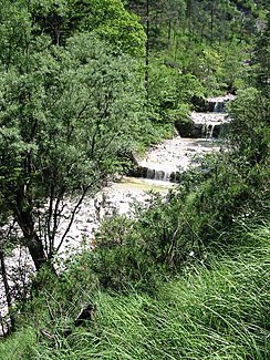
Weißbach Gorge between the headwaters and Speikbach |
||
The Weißbach rises in Bavaria on the northern slope of the Dreisesselberg , which belongs to the mountain range of the Lattengebirge . Its source is about 900 m above sea level. NN . It flows through the so-called Weißbach Gorge between Hochplatte (911 meters) and Lattenberg (909 meters) and joins the Grabenbach , northeast of Bad Reichenhall , which flows into the Saalach shortly afterwards .
The Weißbach is generally classified as a mountain stream , but has been almost completely tamed with rubble barriers / base belts since around 1910 in the course of a torrent control . In the upper course it has drinking water quality. The name was first mentioned in 788 as "Wizinpach" . The pale limestone gravel from the Lattengebirge on its bottom gave the stream its name.
In the 15th and 16th centuries the trend of bread-baking came up in the Gmainer area, the Weißbach represented a formal Eldorado for mills . The most important in Bavarian territory are the straw mill and the upper mill, while the zenonian binder mill and the old mill remain in Salzburg at the Meierhof - the latter was, so to speak, the court mill of the Plainburg . In the village of Weißbach (near Marzoll- Bad Reichenhall), which is named after the water it flows through, there were three mills: the Obermühle (first mentioned in 1415, an inn since 1872), the Mittermühle (since 1350, demolished in 1961) and the Poschen or Untermühle (since 1348)
From around 1860 to December 31, 1909, hydropower was also used to operate the Hartmann cement factory in Leopoldstal .
In parts it represents the border between Großgmain ( Austria ) and Bayerisch Gmain ( Germany ).
literature
- Johannes Lang / Max Schneider: On the Gmain, chronicle of the communities Bayerisch Gmain and Großgmain . Bayerisch Gmain municipality / Großgmain municipality 1995.
- Herbert Fröhlich: Marzoll, an Upper Bavarian chronicle . Bad Reichenhall 2008, ISBN 978-3-00-024175-8 .

