Wellucken
|
Wellucken
Market Neunkirchen am Brand
Coordinates: 49 ° 37 ′ 13 ″ N , 11 ° 5 ′ 25 ″ E
|
|
|---|---|
| Height : | 355 (352-361) m above sea level NHN |
| Residents : | 8 (Dec 31, 2018) |
| Postal code : | 91077 |
| Area code : | 09134 |
|
The Neunkirchen district of Wellucken
|
|
Wellucken is a district of the Upper Franconian community Neunkirchen am Brand .
geography
The Franconian hamlet is located in the Erlanger Albvorland , about three kilometers west-northwest of Neunkirchen.
history
Wellucken was first mentioned in a document in 1318. Until the beginning of the 19th century, the place was under the sovereignty of the bishopric of Bamberg . The Bailiwick about the only property in the village was from the Office Neunkirchen as Bailiwick Office exercised. This office was also entitled to the highest jurisdiction as a central office . In addition, as a caste office, it also had the manorial power over the former wasteland. In church matters, the residents of the Catholic parish of Neunkirchen were assigned.
As a result of the administrative reforms in the Kingdom of Bavaria at the beginning of the 19th century, Wellucken became part of the rural community of Dormitz with the second municipal edict in 1818 , which also included the village of Ebersbach and the desert Erleinhof . More than a decade before the communal territorial reform in Bavaria in the 1970s, Wellucken and Ebersbach were transferred to Markt Neunkirchen am Brand in 1960. Wellucken had eight residents in 2018.
When the Bamberg bishopric was secularized as a result of the Reichsdeputationshauptschluss 1802/03 and annexed by the Electorate Palatinate-Baiern in breach of the Imperial Constitution , Wellucken became part of the New Bavarian territories created by the "Napoleonic land consolidation" .
traffic
A cul-de-sac leads to the place, which branches off from the community road leading from Marloffstein to Ebersbach. The hamlet is not served by public transport ; the nearest train station on the Nuremberg – Bamberg railway line is in Baiersdorf .
Attractions
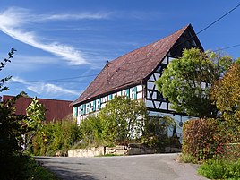
There is a listed farmhouse in Wellucken.
literature
- Ingomar Bog: Forchheim . In: Historical Atlas of Bavaria . Commission for Bavarian State History, Munich 1955.
- Gertrud Diepolder : Bavarian History Atlas . Ed .: Max Spindler . Bayerischer Schulbuch Verlag, Munich 1969, ISBN 3-7627-0723-5 .
- Johann Kaspar Bundschuh : Wellucken . In: Geographical Statistical-Topographical Lexicon of Franconia . tape 6 : V-Z . Verlag der Stettinische Buchhandlung, Ulm 1804, DNB 790364328 , OCLC 833753116 , Sp. 158 ( digitized version ).
- Federal Statistical Office (Hrsg.): Historical municipality register for the Federal Republic of Germany. Name, border and key number changes in municipalities, counties and administrative districts from May 27, 1970 to December 31, 1982 . W. Kohlhammer, Stuttgart / Mainz 1983, ISBN 3-17-003263-1 .
Web links
- Bavarian authorities guide for Wellucken , accessed on October 28, 2019
- Wellucken in the BayernAtlas , accessed on October 28, 2019
- Wellucken on a historical map , accessed October 28, 2019
- Wellucken in the Topographia Franconiae of the University of Würzburg , accessed on October 28, 2019.
Individual evidence
- ↑ a b Population of Wellucken on the Neunkirchen am Brand website , accessed on October 28, 2019
- ↑ a b Description of the location of Wellucken on the Neunkirchen am Brand website , accessed on October 28, 2019
- ↑ Gertrud Diepolder : Bavarian History Atlas . Ed .: Max Spindler . Bayerischer Schulbuch Verlag, Munich 1969, ISBN 3-7627-0723-5 , p. 31 .
- ↑ Gertrud Diepolder : Bavarian History Atlas . Ed .: Max Spindler . Bayerischer Schulbuch Verlag, Munich 1969, ISBN 3-7627-0723-5 , p. 97-103 .
- ^ Ingomar Bog: Forchheim . In: Historical Atlas of Bavaria . S. 88 .
- ↑ Johann Kaspar Bundschuh : Wellucken . In: Geographical Statistical-Topographical Lexicon of Franconia . tape 6 : V-Z . Verlag der Stettinische Buchhandlung, Ulm 1804, DNB 790364328 , OCLC 833753116 , Sp. 158 ( digitized version ).
- ^ Ingomar Bog: Forchheim . In: Historical Atlas of Bavaria . "Hochgerichtkarte" card supplement .
- ^ Ingomar Bog: Forchheim . In: Historical Atlas of Bavaria . S. 114 .
- ↑ Gertrud Diepolder : Bavarian History Atlas . Ed .: Max Spindler . Bayerischer Schulbuch Verlag, Munich 1969, ISBN 3-7627-0723-5 , p. 35 .
- ↑ Gertrud Diepolder : Bavarian History Atlas . Ed .: Max Spindler . Bayerischer Schulbuch Verlag, Munich 1969, ISBN 3-7627-0723-5 , p. 106-107 .
