Weser lowlands
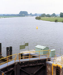
To the north of Porta Westfalica , the Weser no longer flows through a valley , but through the broad Weser lowland , consisting of floodplains and terraced areas .
This valley is partly accompanied by geestruins . From Langwedel to the Lesum , it is separated from the Wümmeniederung by a narrow dune ridge , on which the city of Achim and the older parts of Bremen are located. In some places, such as south of the Aller estuary or in Bremen-Huchting , the Weser lowlands merge into moor and marshland without any clear delimitation . The southern part of the Weser lowlands belongs to North Rhine-Westphalia with the cities of Minden and Petershagen . The latter also includes Westphalia's northernmost Weser town, Schlüsselburg . To the north of it, the Weser passes the Lower Saxony Stolzenau .
Below Hoya , the Weser reaches the Breslau-Magdeburg-Bremen glacial valley coming from the southeast . Corresponding to its northwest direction, the edge of the Wildeshauser Geest recedes to the west and the Weser lowland widens to a width of around twenty kilometers. There are also fractured landscapes here . From Achim to Bremen- Blumenthal , it is about ten kilometers wide. In the broad sections of the lowland, the soil does not consist of river sediments or bog, but is also sandy in places. These sandy areas at the low level are also known as Vorgeest , but are separated from the rising Geestrand by a boggy strip. The largest are the Schwarmer Heide and the Thedinghäuser Vorgeest . Down the river from Bremen, the Stedingen marshland extends close to the Weser . It is separated from the northwestern Geestrand by a broad, now largely cultivated strip of bog.
The eastern edge of the Weser lowlands lies less far from the river from the Allermouth near Verden to Bremen- Rönnebeck . In Bremen, south of the Lesum, the Bremen dune separates the Weser lowlands from the Wümmen lowlands. North of the Lesum, the Osterholzer Geest near Bremen- Vegesack forms a steep bank.
In the northern part the Weser lowlands merge into the coastal marshes . There is no natural elevation between the Weser and the Jade Bay to the northwest of the mouth of the Huntes . The sea level of this peninsula consisting of Stadland and Butjadingen is between 0.8 meters below sea level and 1.2 meters above sea level (a point on the "neck" of the Jade Bay 2 meters). There is only a Geestrück beyond the Jade Bay, the Frisian Wehde . On the east side of the Lower Weser, north of Neuenkirchen, the edge of the Osterholzer Geest deviates six to ten kilometers from the river. The marshland is called Osterstade here .
Local authorities
Politically, the following regional authorities share the Weser lowlands, which, with the exception of the Minden-Lübbecke district and the city of Bremen, belong to the state of Lower Saxony :
- District of Minden-Lübbecke ( North Rhine-Westphalia )
- Nienburg district
- Verden district
- District of Diepholz
- the independent city of Delmenhorst
- Free Hanseatic City of Bremen
- Wesermarsch district
Individual evidence
- ^ Osterholz district, overview (PDF). Archived from the original on September 27, 2007 ; Retrieved April 18, 2014 .
Web links
-
BfN landscape profiles (arranged downstream):
- Middle Weser Valley
- Verden Weser Valley
- Bremen agglomeration (contains part of the Wesermarschen)
- Wesermarschen (without Bremen)
literature
- LGN = Land surveying and geographic base information Lower Saxony: Regional maps 1: 100 000, No. 10 "Mittelweser" and No. 2 "Nordoldenburg"
Coordinates: 52 ° 26 ' N , 9 ° 1' E

