
Stadland
| coat of arms | Germany map | |
|---|---|---|

|
Coordinates: 53 ° 25 ' N , 8 ° 22' E |
|
| Basic data | ||
| State : | Lower Saxony | |
| County : | Wesermarsch | |
| Height : | 0 m above sea level NHN | |
| Area : | 113.39 km 2 | |
| Residents: | 7404 (Dec. 31, 2019) | |
| Population density : | 65 inhabitants per km 2 | |
| Postcodes : | 26935, 26936, 26937 | |
| Primaries : | 04732 , 04737 , 04734 , 04731 | |
| License plate : | BRA | |
| Community key : | 03 4 61 009 | |
| Address of the municipal administration: |
Am Markt 1 26935 Stadland |
|
| Website : | ||
| Mayor : | Klaus Rübesamen ( SPD ) | |
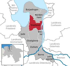
| Location of the municipality of Stadland in the Wesermarsch district | ||
  |
||

Stadland is a municipality in the Wesermarsch district in northwestern Lower Saxony . The seat of the community is Rodenkirchen .
The word Stadland
The term “Stadland” is said to have come up when, after the battle of Altenesch, Stedinger fled from the area southeast of the Hunte to the Frisian land north of the Hunte, which was still free in the 13th century. That would also explain the Latin name for the Stadland ("Terra Stedingorum Rustringie"). In this term, a distinction is made between Frisian (more precisely: Rüstringian ) and Saxon "Stedinger".
Not all researchers recognized the intention to differentiate between rüstringian and non-rüstringian "steders" as such. As a result, some consider Stedingen to be part of Rüstringen. Non-Latin speaking locals, however, always viewed Stedingen and Stadland as neighboring but separate landscapes.
Since 'Stadland' is part of the Wesermarsch on the left bank and the march on the right bank of the Unterweser is called ' Osterstade ', it makes sense to use both names (and possibly - with umlaut - also 'Stedingen') regardless of all historical and political connections to the Word 'Gestade' for bank.
geography
location

The municipality of Stadland largely coincides with the historic Stadland landscape . Together with the landscape of Butjadingen, this forms a peninsula between the Lower Weser and Jadebusen and is one of the flattest areas in Germany with heights between 1.2 and 0.8 meters below sea level . While the marshland has always been very deep, the level of the raised bogs in the southwest of the Stadland was up to four meters higher than it is now until they were cultivated, so that they were not flooded with dike breaches. Before the construction of sufficiently high dykes, the settlements were preferably on terps .


Neighboring communities
The municipality of Stadland borders in the northwest on the municipality Butjadingen and in the northeast on the city of Nordenham . In the east it borders on the Lower Weser and in the west on the Jade Bay . The town of Brake is to the southeast, the municipality of Ovelgönne to the south and the municipality of Jade to the southwest . All surrounding communities belong to the Wesermarsch district .
Community structure
The community consists of the places Rodenkirchen, Schwei , Seefeld and Kleinensiel . Originally the districts were independent communities; however, these were combined in the 1970s.
With around 4,000 inhabitants, Rodenkirchen is the largest town in the community, as well as a school and sports center and the seat of the local government. The name, which the place received in 1244, means something like "Crucifixion Church " and can be traced back to the St. Matthew Church in the center, in which there are important wood carvings (altar and pulpit) by Ludwig Münstermann . The Low German poet Alma Rogge was born on a farm in Brunswarden near Rodenkirchen (“Wo ik kaam, consecrates the wind…”).
Switzerland has around 1500 inhabitants. The center of the place is the St. Secundus Church ; Both the altar of the church and the pulpit and baptismal font were designed by Ludwig Münstermann . To the former municipality of welding include the farming communities Norder welding , dog Moor , Southshore welding , Schweieraußendeich , Schweieraltendeich , Schweierfeld and sweat-West .

Seefeld was created in 1643 through dikes and land reclamation. The place is mainly characterized by agriculture. The cultural center is the Seefelder Mühle , the landmark of the place, where over 50 events take place every year. The village of Reitland , which is part of Seefeld, is a stronghold for the Frisian sports Boßeln and Klootschießen .
With around 800 inhabitants, Kleinensiel is the smallest town in the municipality. Already in the 11th century there was a ferry connection to the other side of the Weser to Dedesdorf in the Kleinensiel district . This was discontinued in January 2004 after the construction of the Weser tunnel . The next fixed land crossing over the Weser is on the edge of Bremen city center .
history
20th century

In addition to the historical marshland Stadtland along the Weser, today's municipality also includes an area on the east coast of the Jade Bay, which was covered with moor around 1500 and was barely inhabited.
At the end of the Weimar Republic , Stadland developed into a Nazi stronghold; The NSDAP achieved 49 percent in the Oldenburg state elections on May 27, 1932 in Rodenkirchen - SPD: 27.3 percent - and in the Reichstag elections on July 31, 1932 even 58.7 percent.
The municipality of Stadland was founded in the 1970s by merging the municipalities of Seefeld, Schwei and Rodenkirchen.
From 1946 Stadland belonged to the Lower Saxony administrative district of Oldenburg and from 1978 to 2004 to the administrative district of Weser-Ems .
Traffic history
In 1875 Rodenkirchen received its first rail connection by extending the Hude - Elsfleth line to Nordenham. In 1913 an east-west connection was added from Rodenkirchen via Schwei to Varel , which was shut down in 1958.
Incorporations
During the Lower Saxony regional reform , which came into force on March 1, 1974, the former communities of Rodenkirchen, Schwei, Seefeld and Kleinensiel, which previously belonged to Esenshamm, were combined to form the municipality of Stadland.
Population development

|
(as of December 31st)
politics
Municipal council
The municipal council of the municipality of Stadland consists of 20 councilors. This is the specified number for a municipality with a population between 7,001 and 8,000. The 20 council members are elected by local elections for five years each. The current term of office began on November 1, 2016 and ends on October 31, 2021.
The full-time mayor Klaus Rübesamen is also entitled to vote in the municipal council.
The last local election on September 11, 2016 resulted in the following:
| Political party | Proportional votes | Number of seats | Change voices | Change seats |
|---|---|---|---|---|
| CDU | 35.32% | 7th | −4.61% | −1 |
| SPD | 38.86% | 8th | + 4.29% | +1 |
| Alliance 90 / The Greens | 10.40% | 2 | −1.86% | 0 |
| Pro Stadland voter community (WPS) | 9.64% | 2 | +1.33% | 0 |
| FDP | 3.02% | 1 | + 3.02% | +1 |
| left | 2.72% | 0 | −0.85% | −1 |
The turnout in the 2016 local elections was 56.16%, above the Lower Saxony average of 55.5%. For comparison - in the previous local election on September 11, 2011, the turnout was 53.96%.
mayor
The full-time mayor of the municipality of Stadland is Klaus Rübesamen (SPD). He began his career more than 40 years ago in the police service of the state of Lower Saxony and has since been employed in a wide variety of managerial positions. Before being elected mayor, he was the head of the water police in Brake. Rübsamen was able to prevail in the last mayoral election on September 28, 2014 at the first attempt with 58.26% of the votes against three other candidates. The turnout was 53.82%. The current term of office began on November 1, 2014.
coat of arms
The coat of arms of the municipality is split and divided on the left.
Blazon : On the right, in blue, a standing silver Friesian warrior with an upright silver Friesian spear in his right hand, a silver, humped round shield over the (hidden) left arm and a sword on the left side. At the top left in blue three flying silver seagulls, at an angle at the bottom a silver three-leaf clover in blue.
Town twinning
There has been an official partnership with the French District du Petit Caux in Normandy since 1990/1991 . The District du Petit Caux comprises the area between Dieppe and Criel-sur-Mer or Le Tréport . The German part of the partnership certificate was signed on October 13, 1990 in Rodenkirchen. On May 25, 1991, the French part of the partnership document was signed in the District du Petit Caux . This partnership is reinforced every year through mutual visits by school classes and private individuals.
The Ev.-luth. Parish of Schwei has had a long-term partnership with the St. Johannes parish in Hoyerswerda / Lower Silesia. This partnership was of great importance in GDR times.

Culture and sights
Attractions
- Bronze Age House Hartwarderwurp
- Listed house of the local poet Amanda Jürgens
- Frisian monument in Hartwarden / Rodenkirchen
- Gallery Dutch windmill in Seefeld
- Historic hall ship Hanni on the Abser Siel
- Jade Bay
- St. Matthew Church in Rodenkirchen
- St. Secundus Church in Schwei
- Strohauser Plate (bird sanctuary)
- Weser tunnel in Kleinensiel
Regular events

The annual " Roonkarker Mart " fair takes place in Rodenkirchen at the end of September .
Sports
The general gymnastics club Rodenkirchen from 1908 e. V. ( ATR ) is the largest sports club in the municipality. It was founded on March 10, 1908 and with around 1,500 members is the third largest association in the Wesermarsch .
Economy and Infrastructure
The economic focus is on agriculture and tourism. The quality of living in the community is high, which can be proven not least by new settlement areas. Despite favorable transport connections, the relocation of larger companies is not due to lack of demand. As in the entire Wesermarsch, the unemployment rate is relatively high.
Inflow and drainage
The system of inflow and drainage ditches and canals as well as the sewage depressions are of central importance for the low-lying Stadland . In the area of the Stadlander Sielacht , the entire association area is drained via the Strohauser Sielacht . The association's area is divided into twelve melioration areas.
Energy industry
Stadland is the location of the Unterweser nuclear power plant , which belongs to E.ON AG and went online in 1978. With over 1,400 megawatts, it was one of the most powerful nuclear power plants and was shut down in 2011.
Transport links
Streets
The main roads are the federal highways B212 and B437 , which also includes the Weser tunnel. The A27 and A29 motorways can be reached via the federal highways . Thus, the cities of Oldenburg (Oldenburg) , Wilhelmshaven , Bremen and Bremerhaven can be reached within an hour.
The planned extension of the A20 federal motorway , formerly also known as the A22 federal motorway , is expected to run across the municipality.
railroad
The municipality of Stadland is connected by rail via the Hude – Nordenham railway line : the stops are the stations in Rodenkirchen and Kleinensiel. There are also connections by bus with the cities of Oldenburg, Wilhelmshaven and Bremerhaven.
Long-distance cycle routes
Two long-distance cycle paths lead through the municipality . The Deutsche Sielroute is a long-distance cycle route through the Wesermarsch district . It has a length of 220 kilometers and is mainly characterized by the typical landscape of the Wesermarsch. The Weserradweg is a 491 kilometer long long-distance cycle path from Hann. Münden to Cuxhaven along the Weser. Local catering companies and private tourist rooms invite you to spend the night or take a break. There is a Melkhus at the Beckumersiel sheep farm .
media
The municipality of Stadland is located in the catchment area of two daily newspapers. These are the Nordwest-Zeitung with its local section "Wesermarsch-Zeitung" and the Kreiszeitung Wesermarsch .
Personalities
- Alma Rogge (1894–1969), writer
- Carl Thorade (1841-1896), German banker, person of the labor movement and politician
- Dennis Schneider (* 1988), pro gamer and multiple winner of the ESL Pro Series in Warcraft 3 and Starcraft 2
- Franz Radziwill (1895–1983), painter of the New Objectivity
- Helene Ramsauer , Professor of Religious Education at the PH Oldenburg
- Udo Zempel (1925–2012), politician (SPD), 1974–1990 member of the Lower Saxony state parliament , former district administrator of the Wesermarsch district
- Walter Renzelmann , pastor in Schwei, first Lutheran preacher in the county of Oldenburg.
- Wilhelm Schwecke , politically committed rector from Alse
literature
- Jens Schmeyers: The last free Frisians between Weser and Ems: The history of Butjadingen and Stadland up to the battle at Hartwarder Schanze . Lemwerder. Stedinger Verlag 2006
- Albrecht Graf Finckenstein: The history of Butjadingens and the Stadland until 1514, Heinz Holzberg Verlag, Oldenburg 1975. [ ISBN 3 87358 076 4 ]
Web links
Individual evidence
- ↑ State Office for Statistics Lower Saxony, LSN-Online regional database, Table 12411: Update of the population, as of December 31, 2019 ( help ).
- ^ Heinrich Schmidt: The historical development of the state of Oldenburg ( Memento from March 1, 2016 in the Internet Archive ) (PDF; 784 kB). In: Dietrich Hagen / Heinrich Schmidt / Günter König: Oldenburg. Land between the North Sea and Dammer Mountains . Hanover. Lower Saxony State Center for Political Education 1999, p. 49
- ↑ NAZI TIME IN URBAN LAND - news from the evil empire
- ^ Federal Statistical Office (ed.): Historical municipality directory for the Federal Republic of Germany. Name, border and key number changes in municipalities, counties and administrative districts from May 27, 1970 to December 31, 1982 . W. Kohlhammer GmbH, Stuttgart and Mainz 1983, ISBN 3-17-003263-1 , p. 276 and 277 .
- ↑ LSKN-Online
- ^ Lower Saxony Municipal Constitutional Law (NKomVG) in the version of December 17, 2010; Section 46 - Number of MPs , accessed on January 2, 2017
- ↑ a b Municipality of Stadland - overall results of the 2016 municipal council election , accessed on January 2, 2017
- ↑ The CDU gets the most votes nationwide. September 12, 2016, accessed January 2, 2017 .
- ↑ Municipality of Stadland - overall results of the mayoral election on September 28 , 2014, accessed on November 4, 2014
- ↑ Main statutes of the municipality of Stadland ( page no longer available , search in web archives ) Info: The link was automatically marked as defective. Please check the link according to the instructions and then remove this notice. (PDF; 29 kB), accessed on April 4, 2012
- ^ The Petit Caux Circle of Friends , accessed on April 4, 2012
- ↑ Marcus Malsy: Analysis of the inflow and drainage systems in the Wesermarsch: history, function and adaptation strategies to climate change , thesis Carl von Ossietzky University of Oldenburg, April 30, 2010, p. 46 f.
Berne | Brake (Lower Weser) | Butjadingen | Elsfleth | Jade | Lemwerder | Nordenham | Ovelgönne | Stadland
Rodenkirchen with Kleinensiel , Beckum , Hartwarden , Hayenwärf , Alserwurp , Strohausen , Tegelland , Absen , Alse , Sürwürden , Strohauser Plate | Schwei with Schweieraußendeich , Norderschwei , Kötermoor , Süderschwei , Schweierfeld , Schwei II | Seefeld with Augustgroden , Norderseefeld , Seefeldermoor , Norderaußendeich , Morgenland , Süderaußendeich , Reitland