
Seefeld (Stadland)
|
Seefeld
Stadland municipality
|
||
|---|---|---|
 |
||
| Height : | 1 m above sea level NN | |
| Residents : | 1565 (2012) | |
| Incorporation : | March 1, 1974 | |
| Postal code : | 26937 | |
| Area code : | 04734 | |
Location of Seefeld in Lower Saxony |
||

The village of Seefeld is located east of the Jadebusen bay ; together with the villages of Rodenkirchen and Schwei , it forms the municipality of Stadland , which is located in the Wesermarsch district in Lower Saxony .
Districts
Seefeld consists of the farmers : Augustgroden , Norderseefeld , Seefeld, Seefeldermoor , Norderaußendeich , Morgenland , Süderaußendeich and Reitland .
Geography and landscape
Seefeld is located in the middle of a cultural landscape that is characterized by land reclamation measures. A marsh and moor colonization can be found in the vicinity of Seefeld, which follows on from the tradition of the elder colonization of Stedingen . There are also Groden landscapes that emerged in the area of the Lockfleth and were reclaimed after it was dammed . The area historically known as "Seefeld" is located north of today's village. The courtyards that were founded in the middle of the 17th century under the leadership of the Oldenburg counts still stand here today. These courtyards and the associated parcels stand out from the surrounding landscape. In contrast to the usual row villages in the area, they stand alone and have no elongated parcels. In the area around Seefeld there are numerous Frisian Gulf houses and Low German hall houses . The village of Reitland is located southwest of Seefeld ; east of the Orient ; west of Augustgroden .
history


middle Ages
There is no evidence as to whether people lived in the Seefeld area before the early modern era . The medieval Johanniterkommende Inte is occupied about three kilometers north .
Drainage of the lockfleth

Seefeld is located in the flood area of the historic Lockfleth estuary , which with the Second Marcellus Flood in 1362 found a way from the Jade Bay through the Wesermarsch to the Weser at today's Brake . Before that there was a moor in the area of the "Seefeld" . The inlet separated the Stadland and Butjadingen from the mainland, creating an island location. With the conquest of the area after the battle of the Hartwarder Landwehr by the Oldenburg Counts , the drainage of the Lockfleth began in the 16th century, the purpose of which was, in addition to economic aspects, the politically desired physical connection of the Stadland to the Oldenburg dominion. This drainage is crucial for the development of the Seefeld area. Under Count Johann V von Oldenburg around 1516 a dike was built across the Lockfleth river bed near Ovelgönne. The subsequent dike sections (1520, 1530, 1555, 1557, 1591, 1643) advanced further and further west towards the Jade Bay.
Early modern age
New lift
A special structural achievement was the extraction of the new Hoben , the part of the flood area of the Lockfleth which lies east of Seefeld. The dike built for this purpose was built over seven years and was completed in 1591. The dike also crossed the bed of the Lockfleth, which has not yet dried out, which is why this area is still much deeper than the surrounding area. Today's Seefelder Straße follows the course of this dike to Abbehauser Hörneweg, on which the dike continued to the northeast. Due to the lack of current and the associated deposition of sediments, a valley , the “ Seefeld” , formed in front of this dike . Under Count Anton Günther , this “ Seefeld ” was wrested from the sea with the construction of the New Hobendeich in 1643 .
Reclamation of the Seefelds

The fertile area west of today's Seefelder Straße, like the other newly won lands in the Lockfleth river bed, was claimed as the sovereign property ( allod ) of the Oldenburg counts and colonized with a count's Vorwerk . About two thirds of the 870 hectare land went to the Vorwerk. A third was given to beneficiaries of the count, such as the Blankenburg monastery or the wife of Count Princess Sophie Katharina von Holstein-Sonderburg. Count Anton Günther gave the most valuable piece of land to his diplomat Hermann Mylius in 1648 for his services in anchoring the Weser toll . He set up the noble free estate Gnadenfeld there (today opposite the restaurant on Seefelder Schaart).
Anton I von Aldenburg inherits Seefeld
Since Count Anton Günther von Oldenburg had no legitimate heir, he managed to legitimize his illegitimate son Anton I von Aldenburg with great difficulty . Most of Anton Günther's inheritance went to the Kingdom of Denmark , but the count managed to endow his legitimate son with the rule of Kniphausen , which also included "Seefeld".
Church building
Anton I von Aldenburg had a church consecrated in 1679 built for his hirers in Seefeld, Morgenland and Seefeld outer dyke on the old dike built in 1591 . After the founding of the church, the center of today's Seefeld was formed, the Seefelder Kirchdorf or Neuenkirchen , whose name was changed to Seefeld shortly afterwards .
Origin of the church village
One of the first buildings in the church village was the pastorei, which was built in 1676. The first Küsterei with a school is recorded for 1677. This was followed by a shop and an inn. The early modern Seefeld is documented on the map section of the Vogtei Schwey of the Oldenburg Vogteikarte. The size of the settlement was 10 courtyards, which were in the immediate vicinity of the church on the old dike. In addition to the courtyards by the church, there was a second town center around Gut Gnadenfeld, both of which grew together over time.
19. – 20. century
Brick factory
Seefeld had a brick factory in the 19th century . This was built in 1874 by the domain tenant Friedrich Reinhard Bruns about 200 meters east of the Seefelder Mühle and north of the main road. Perhaps the owner was hoping for a good deal, because at that time roads were being built from clinker, such as the Varel - Rodenkirchen route , on which 14 brick factories were working across the region. At that time there were other brickworks in Burhave , north and south of Atens and in Rodenkirchen. The agricultural property "Hobenhausen" was previously located on the brickyard's land. The brickworks processed the earth of the dike built in 1574, on which the buildings on Seefeld main street are today. In addition, soil has been prepared by Hoben dike by Loren trains fetched on a railway embankment up to the brick went from Raitlanderzoll no. 7 in west-east direction.
Shortly after the turn of the century, 1.25 million bricks are said to have been produced in the brickyard each year. The brick factory employed 12 workers. From 1896 to 1910 the complex included around 8 hectares of land. Another brickworks that also bricked a dike was located south of Grünhof, near Binnenau. The stones produced in Seefeld and Binnenau were of poor quality due to the nitric soil.
inch
Some place names still indicate the existence of a customs at Seefeld, Reitlander and Schweierzoll were places where the roads were closed in order to raise a road usage fee. In 1818 internal tariffs in Germany were replaced by border tariffs. A uniform customs area has existed in German-speaking countries since 1834. In 1938, the Hauptzollamt Wilhelmshaven built a customs house and apartments for two families of customs officers in Augustgroden house number 29. These officers were supposed to check passers-by for uncleared goods and look out for smugglers on the dike and in the Groden .

20th century
In the 1920s, a power supply was ensured in Seefeld. During the Second World War , the Seefeld heavy flak battery was built in Augustgroden . Wehrmacht barracks stood in Reitlanderzoll. The flak bunkers located there were blown up in the immediate post-war period. Isolated bombs were probably aimed at this battery or were "emergency drops", they caused only minor war damage and did not claim any human life. The first displaced persons came to Seefeld in March 1945 ; they came from Silesia and East and West Prussia , among others . The population grew by almost half as a result of the influx of displaced people in the Seefeld community. The local families had to vacate rooms to accommodate these people. Lower Saxony was part of the British zone of occupation . In May 1945 Canadian troops briefly occupied the so-called German House (today the village community center) in the center of Seefeld.
Administrative history
From 1643 to 1811 when the “Seefeld” was dyed, Seefeld belonged to the Vogtei Schwei . It was part of the Kniphausen rule . Seefeld was from 1811 to 1813 was part of the French Empire in the Arrondissement of Oldenburg in the Département des Bouches-du-Weser . Seefeld was later an independent municipality. From 1933 to 1948 Seefeld was part of the Abbehausen community. In 1948 the Seefeld community was restored. Seefeld has been part of the newly founded municipality of Stadland since 1974.
Street names
The street names of today's settlement are mostly reminiscent of local history. The earliest known settlers in the Wesermarsch area were the Chauken (Chaukenstraße); after the migration period , the Frisians appeared as residents (Friesenring). Count Anton Günther (Anthon-Günther-Straße) was responsible for the dike in Seefeld, his trusted diplomat Hermann Mylius (Myliusstraße) was the master of the Gnadenfeld estate. The son of Anton Günther Anton I von Aldenburg (Von-Aldenburg-Straße) had the church built. For the construction of a brick road from Varel to Rodenkirchen, a brick factory was founded 200 meters east of the mill in the middle of the 19th century , which processed the soil from the dike from 1574. The street name "Am Ziegeldeich" is a reminder of this brick factory. The original church village only had one path that ran along the old dike, the Sülten - or Sülzenweg (Salzenweg) led from the church to today's intersection of Hauptstrasse / Kleistrasse.
Attractions

Floating moor
Southwest of Seefeld, near Sehestedt, is the unique floating moor on the Jade Bay . The natural monument is the only outside dike in the world and is under nature protection.
Seefeld mill
The Seefelder Mühle is the landmark of the place.
Seefeld Church
The Seefeld Church was built in 1675 as a hall church in the North German Baroque .
Bronze Age House Hartwarderwurp
The Hartwarderwurp Bronze Age House is located south of Seefeld .
Infrastructure
There is a primary school in Seefeld, which has now been merged with the Schwei primary school. Years 1 and 2 are trained here. There is a sports hall, a soccer field and tennis courts in town.
societies
- Fanfare and Spielmannszug Seefeld eV
- Klootschießer- und Boßelverein Seefeld eV
- Schützenverein Seefeld eV
- Sportgemeinschaft Schwei-Seefeld-Rönnelmoor eV
- Seefeld gymnastics club
Demographics
| year | Residents |
|---|---|
| 1769 | 1.009 |
| 1793 | 1,061 |
| 1805 | 1,238 |
| 1813/14 | 1,224 |
| 1815 | 1,298 |
| 1858 | 1,622 |
| 1925 | 1,787 |
| 1939 | 1,767 |
| 1946 | 2,217 |
| 1948 | 2,376 |
| 2012 | 1,565 |
Famous pepole
- Hermann Mylius (1603–1657), Oldenburg diplomat with the title of Gnadenfeld
- Carl Peter Wilhelm Gramberg (1797–1830), theologian and educator
- Carl Heinrich Thorade (1841-1896), German banker, person of the labor movement and politician
literature
- Hugo Ahlhorn: The history of Seefeld , Sottrum (Verlag Werbung and Verlag) 1984.
- Hermann Lübbing , Oldenburg. Historical contours. Festschrift for the 70th birthday. Oldenburg (Heinz Holzberg Verlag) 1971. ISBN 3-87358-045-4
- Wolfgang Runge, churches in the Oldenburger Land. Vol. I: Church districts Butjadingen, Brake, Elsfleth. With a note on Ludwig Münstermann. Oldenburg (Heinz Holzberg Verlag) 1983 pp. 97-104. ISBN 3-87358-167-1
- Gerold Schmidt: The Oldenburg family Schmidt from Seefeld. Stammliste and ancestors list , Oldenburgische Familienkunde, Jg. 24 H. 2/1982, 43 p., Fig. U. Coat of arms.
- Johannes Ey: High Middle Ages and early modern development between Jade Bay and Weser, in: Problems of coastal research around the southern North Sea region, Volume 18, Hildesheim 1991.
- Karl-Ernst Behre : The history of the landscape around the Jade Bay - Friesland - Wilhelmshaven. Brunde-Mettcker Druck- und Verlagsgesellschaft mbH, Wilhelmshaven 2012.
- Albrecht Eckhardt : Oldenburg local dictionary. LZ. Ed .: Albrecht Eckhardt. Volume 2. Isensee Verlag, Oldenburg 2011, pp. 913-915.
Web links
Individual evidence
- ^ A b c Max Hannemann: The district of Wesermarsch . Walter Dorn Verlag Bremen Horn, Bremen 1954, p. 110 .
- ↑ a b c Karl-Ernst Behre: The history of the landscape around the Jade Bay. Friesland - Wilhelmshaven - Wesermarsch . Brunde-Mettcker Druck- und Verlagsgesellschaft mbH, Wilhelmshaven 2012, ISBN 978-3-941929-02-9 , p. 158-167 .
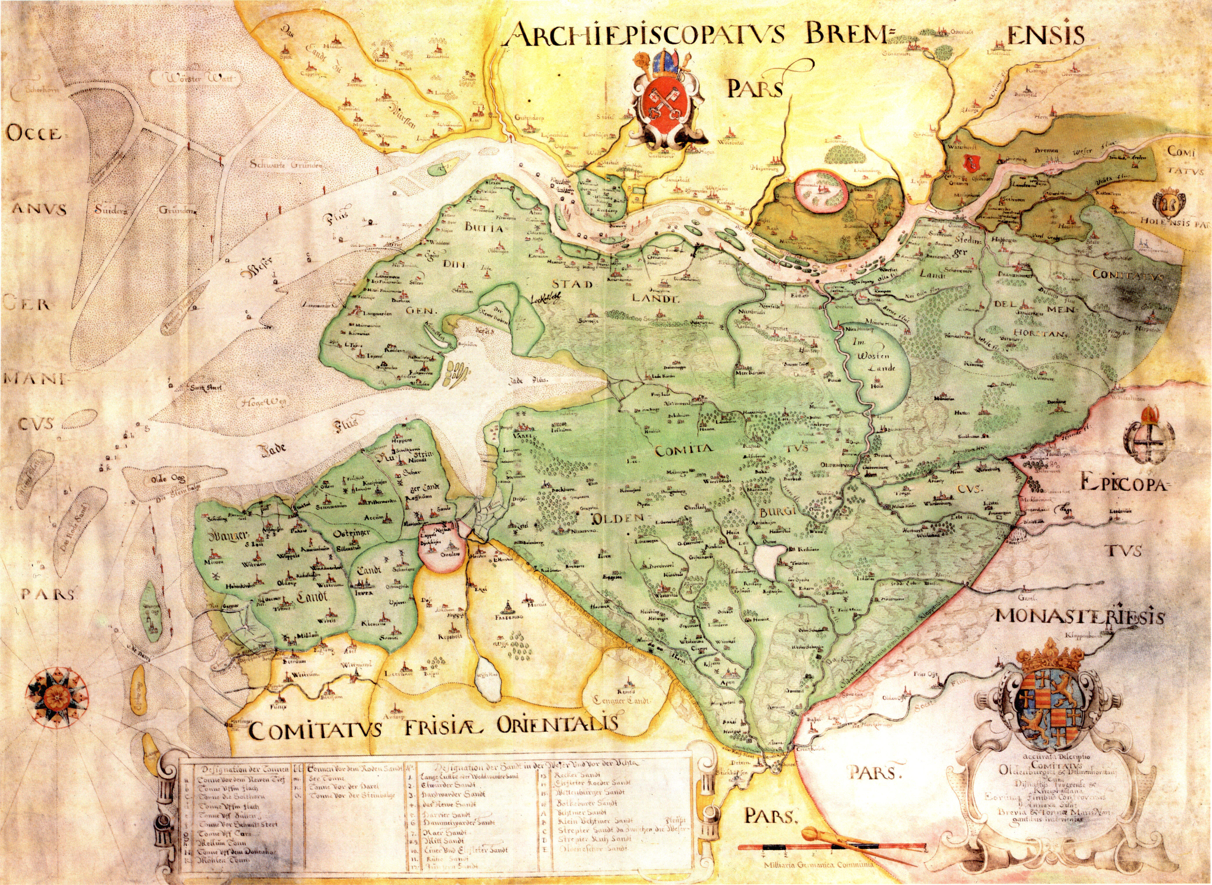
- ↑ Maps of the County of Oldenburg: 17th century → Gerhart Muntinck: Accurata Descriptio Comitatus Oldenburgici & Delmenhorstanai (around 1648)
- ↑ Johannes Ey: High Middle Ages and early modern development between the Jade Bay and the Weser . In: Lower Saxony Institute for Historical Coastal Research (Hrsg.): Problems of coastal research in the southern North Sea area . tape 18 . August Lax, Hildesheim 1991, p. 78 .
- ↑ a b c d e f g h i j k K.H. Ziessow / A. Eckhardt .: Oldenburg local dictionary. LZ. Ed .: Albrecht Eckhardt. tape 2 . Isensee Verlag, Oldenburg 2011, p. 913-915 .
- ^ Hugo Ahlhorn: The history of Seefeld . Advertising and publishing house Sottrum, Sottrum 1984, p. 59-62 .
- ^ A b Hugo Ahlhorn: The history of Seefeld . S. 47 f .
- ^ Hugo Ahlhorn: The history of Seefeld . S. 51 .
- ^ Hugo Ahlhorn: The history of Seefeld . Advertising and publishing house Sottrum, Sottrum 1984, p. 56 .
- ^ Hugo Ahlhorn: The history of Seefeld . Advertising and publishing house Sottrum, Sottrum 1984, p. 59-62 .
- ↑ a b c Hugo Ahlhorn: The history of Seefeld . Advertising and publishing house Sottrum, Sottrum 1984, p. 196 f .
- ^ A b Hugo Ahlhorn: The history of Seefeld . Advertising and publishing house Sottrum, Sottrum 1984, p. 182 f .
- ^ Hugo Ahlhorn: The history of Seefeld . Advertising and publishing house Sottrum, Sottrum 1984, p. 195 ff .
- ↑ K.-H. Ziessow / A. Eckhardt .: Oldenburg local dictionary. LZ. Ed .: Albrecht Eckhardt. tape 2 . Isensee Verlag, Oldenburg, p. 906 .
- ^ Federal Statistical Office (ed.): Historical municipality directory for the Federal Republic of Germany. Name, border and key number changes in municipalities, counties and administrative districts from May 27, 1970 to December 31, 1982 . W. Kohlhammer GmbH, Stuttgart and Mainz 1983, ISBN 3-17-003263-1 , p. 276 .
- ^ Hugo Ahlhorn: The history of Seefeld . Advertising and publishing house Sottrum, Sottrum 1984, p. 84-90 .
- ↑ Nordwestzeitung (ed.): Historical names for streets in the Seefeld new building area . April 28, 1980.
- ^ Hugo Ahlhorn: The history of Seefeld . Advertising and publishing house Sottrum, Sottrum 1984, p. 47 .
- ↑ Worth seeing churches in the Wesermarsch , accessed on February 28, 2014.
- ↑ a b c Adolf Blumenberg: Land and people between Weser and Jade . Ed .: Nordwest-Zeitung. tape 1 . Nordwest-Zeitung Druck und Pressehaus, Oldenburg 1981, p. 69 .
- ↑ Anna-Maria Weiß: The number of inhabitants in the municipality of Stadland is falling slightly. August 24, 2012. Retrieved July 17, 2018 .

Rodenkirchen with Kleinensiel , Beckum , Hartwarden , Hayenwärf , Alserwurp , Strohausen , Tegelland , Absen , Alse , Sürwürden , Strohauser Plate | Schwei with Schweieraußendeich , Norderschwei , Kötermoor , Süderschwei , Schweierfeld , Schwei II | Seefeld with Augustgroden , Norderseefeld , Seefeldermoor , Norderaußendeich , Morgenland , Süderaußendeich , Reitland