Wilisch (mountain)
| Wilisch | ||
|---|---|---|
|
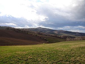
Wilisch from Finckenfang at Maxen seen from |
||
| height | 476.2 m above sea level HN | |
| location | Saxony ( Germany ) | |
| Mountains | Ore Mountains | |
| Coordinates | 50 ° 55 ′ 18 ″ N , 13 ° 45 ′ 1 ″ E | |
|
|
||
| rock | Basalt chimney in conglomerate | |
| Age of the rock | Basalt: Tertiary Conglomerate: Unterperm |
|
The Wilisch is a 476 m high mountain in the Eastern Ore Mountains not far from Dresden . The upper part of the mountain consists of basalt , which was mined in a large quarry on the northwest flank of the summit.
Location and surroundings
The Wilisch is located about 15 km south of Dresden and 5 km east of Dippoldiswalde in the Saxon Switzerland-Eastern Ore Mountains district on the territory of the city of Glashütte . At the northern foot there is the municipality of Kreischa with the district Lungkwitz and to the south the towns of Hermsdorf and Hirschbach . Because the Wilisch protrudes from the Kreischa basin to the north and the Dippoldiswalder Heide and Hirschbacher Heide plateaus to the south , it is a landmark .
Little Wilisch
The south-east lying Kleine Wilisch (378 m) served as a basalt quarry in the 20th century, the rock was removed with a wagon train . Gray and red gneiss were extracted from the “Red Quarry”; a mountain spur was dismantled with a medieval weir system .
The Wilischgrund
The Wilischbach drains the Wilisch and the Little Wilisch into the Lockwitzbach at Gasthaus Teufelsmühle. The Wilischgrund cuts deep into the sandstone slab to the south. Two iron-containing springs emerge from the northern side of the slope, which can be easily recognized by their rust color when it is snowing.
Natural space
geology
The Wilisch is located at the southeast end of the Döhlen basin (Hainsberg-Quohrener secondary trough), the rocks of which consist mainly of carbon and Permian conglomerates , sandstones and pyroclastites . The basaltic rock that makes up the summit of the Wilisch, however, is about 200 million years younger and only formed in the Tertiary , when the "hull plate" of the "Ur-Erzgebirge" was subjected to tectonic stresses and its northeastern part (Elbe zone) on the southwestern ( today's Osterzgebirge ) was postponed . At one of the fractures where these movements took place, basic magma rose and solidified in the permocarbon sedimentary rocks to form olivine nephelinite . Due to the erosion of the rocks in the Döhlen basin, a Härtling knoll of approx. 70 m relative height was created. The fracture point that served as the ascent path of the magma is called the Karsdorf Fault . Its outcrop runs barely more than 100 m southwest of the basalt dome. The basaltic rock of the dome is partly fissured into columns that converge towards the top of the dome. From this it can be concluded that it must be a funnel-shaped volcanic vent.
The slopes below the basalt dome are made up of gneiss and rhyolite conglomerates as well as arkose sandstones , which can be assigned to the younger layers of the basin filling of the Döhlen basin (Niederhäslich formation or Bannewitz formation), the lowest part of the south-western flank of the mountain probably also consists of the upcoming Eastern Ore Mountains .
climate
Climatically, the Wilisch and Wendischcarsdorfer Faults form a dividing line between the Ore Mountains and the Elbe Valley. The ridge protects the Kreischa basin from cold air moving down the valley. The Kreischa basin is a fruit-growing area, especially for apples and cherries. The upper slopes of the Wilisch protrude from the cold air and are locations for heat-loving plants and animals.
Flora and fauna
The vegetation on the summit is rich in species. Plants that love alkaline soil predominate in the herb layer. The vegetation of the neighboring sandstone heaths is poor in species. The main game species is the roe deer and fallow deer were released into the wild from 1970. Lizards and adders can be found on the basalt rocks. The low population density provides a habitat and food source for many species of birds of prey.
history

The Wilisch and Wendischcarsdorfer Faults formed the southern settlement limit for the Bronze Age settlers and the Slavs. The poor soils were not attractive to sedentary farmers. Only honey collectors and hunters penetrated beyond the Wilisch into the heathland.
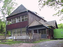
On June 13, 1832, Johann George Vogel, printer from Kreischa, received the right to serve beer on the Wilisch and to erect several green arbours after an application to King Anton . After a few years, a permanent building with a thatched roof was built, called the "Wilischhütte". In 1909 the actual Wilischbaude was built, which belonged to the tourist association for Kreischa and the surrounding area (local branch of the mountain association for Saxon Switzerland ). Otto Werner was the tenant from 1909 to 1961. Then it was used as a holiday home. The Wilischbaude has been empty since 1990. An ongoing renovation of the building was canceled again.
The extraction of basalt in a quarry can already be proven in the second half of the 19th century and lasted until 1923. This made inclined hexagonal basalt columns visible, which allow the conclusion that a former volcanic vent was cut. The quarry floors are laid out in terraces. Ponds occupied by newts have now disappeared.
The excavated material was used to gravel roads in the region, for example near Gittersee .
In September 1867, Christian August Nagel built station no. 61, 2nd order of the Royal Saxon triangulation on the summit of Wilisch, made of Neundorf sandstone . The surveying column was rededicated in 1921 by the Kreischa Mountain Association as a memorial for those who died in the First World War from the community. The station's original inscription was removed and replaced with the years 1914–1918. The column was severely damaged by fire at the end of the Second World War.
Origin of the name
The name of the mountain and the Wilischbach, which runs south, is probably derived from the Old Sorbian name for "wolf" = "wjelk".
view
A view is only possible to the west from the edge of the former quarry. The view sweeps over the undulating landscape of the Eastern Ore Mountains and the Ore Mountains foreland. Distinctive elevations in the field of vision are other Härtlingskuppen in the Eastern Ore Mountains such as the Luchberg (576 m) and the Geisingberg (823 m) as well as the school building in Rabenau .
Paths to the summit
- As far as the former Wilischbaude, a road from Hermsdorf leads up the mountain, which is the most convenient access.
- Hiking trails lead from Kreischa, Hirschbach and from the Teufelsmühle forest car park through the Wilischgrund to the Wilisch.
literature
- Jens Weber, Christian Jentsch, Christian Zänker: The Wendischcarsdorfer Fault and the Wilisch. In: Green League Osterzgebirge e. V. (Ed.): Naturführer Ost-Erzgebirge. Volume 3: Natural history hiking destinations. Sandstein Verlag, Dresden 2007, ISBN 978-3-940319-18-0 , pp. 341-360 ( HTML version )
Web links
Individual evidence
- ↑ W. Pälchen, H. Walter: Geology of Saxony. Schweizerbart, Stuttgart 2008, p. 477
- ↑ R. Beck: Explanations of the special geological map of the Kingdom of Saxony. No. 82, sheet Kreischa. Leipzig 1917, p. 89 f. ( Digitized version )
- ↑ Weber, Jentsch, Zänker: The Wendischcarsdorfer rejection and the Wilisch. 2007 (see literature ), p. 347
- ↑ Weber, Jentsch, Zänker: The Wendischcarsdorfer rejection and the Wilisch. 2007 (see literature ), p. 351
- ↑ Weber, Jentsch, Zänker: The Wendischcarsdorfer rejection and the Wilisch. 2007 (see literature ), p. 344
- ↑ H. B. Geinitz , C. Th. Sorge: Overview of the types of stone used for road maintenance in the Kingdom of Saxony. E. Blochmann & Sohn, Dresden 1869, p. 103 ( digitized version )
- ^ Interest group Nagelsche Säulen and Staatsbetrieb Geobasisinformation und Vermessung Sachsen (Ed.): Historical survey columns in Saxony - a search for traces . Dresden 2012, p. 107.


