
Maxen
|
Maxen
community Müglitztal
Coordinates: 50 ° 55 ′ 25 ″ N , 13 ° 48 ′ 10 ″ E
|
|
|---|---|
| Height : | 363 m |
| Residents : | 524 (May 9, 2011) |
| Incorporation : | March 1, 1994 |
| Postal code : | 01809 |
| Area code : | 035206 |
 Ev.-Luth. Maxen village church
|
|
Maxen is a village with over 500 inhabitants in the Saxon Switzerland-Eastern Ore Mountains district in Saxony , which has been part of the newly formed community of Müglitztal since 1994 .
geography
Geographical location and topography
The parish village lies on a high plateau between the Lockwitztal and the Müglitztal in the Eastern Ore Mountains . Maxen is located around 18 km southeast of the city center of Dresden and around 4 km southeast of Kreischa . With a height of 363 m above sea level. NHN , the place is located around 260 m above the Dresden Elbe level and thus represents the highest part of the community of Müglitz.
The landscape of Maxen is shaped by a moving topography . The relief is determined by rocks of varying resistance with a plateau visible from afar and deep cuts in the larger and smaller flowing waters. The Finckenfang ( ⊙ ) located in the southwest is the highest point in the village with a height of 394 m above sea level. NHN . The Müglitztal and Lockwitztal as well as their tributaries have cut deeply into the plateau of the Maxen area through erosion . The natural area of Maxen lies in the colline level ( hill country ).
Neighboring places
Wittgensdorf and Tronitz borders in the north of Maxen and Schmorsdorf joins in the northeast of the place . Mühlbach is located in the southeast of the village and Hausdorf is in the southwest . Lungwitz is the north-western neighbor of Maxen.
_(03-2).jpg)
Natural allocation
Maxen is naturally assigned to the Eastern Ore Mountains Foreland (Mannsfeld and Syrbe 2008), which is part of the Saxon loess region . In the west of Maxen there is a transition to the Lower Eastern Ore Mountains natural area .
geology
The geology of Maxen consists of a mosaic of different rocks of the Elbe Valley Slate Mountains , which are part of the Elbe zone . In the southwest it borders directly on the Eastern Ore Mountains. The basement was formed during the Variscan Orogeny . In the course of this orogeny phase in the younger half of the Paleozoic Era , the rock complexes of the Elbe Valley Slate Mountains were folded and slightly overprinted by pressure and temperature ( metamorphosis ). In the Lower Carboniferous , granite from Markersbach penetrated ( intrusion ) into this series of rocks . As a result, the surrounding rocks were changed contact-metamorphically. After that, in the Upper Carboniferous, the non- metamorphic rocks of the Lausitz came to lie opposite the metamorphic rocks of the Ore Mountains due to the enormous shifting of leaves . In the meantime, the rock series of the Elbe Valley Slate Mountains also moved, with the result that they have since been between those of the Ore Mountains and the Lausitz. The Eastern Ore Mountains are separated from the Elbe Valley Slate Mountains by the Central Saxon Fault. In the fault area, the rocks are sheared and deformed by the displacement processes that have taken place. The Elbe Valley Slate Mountains are therefore composed of a colorful, weakly metamorphic rock complex and granite.
In addition to layers from the Devonian , such as tuff , layers from the Ordovician with a Frauenbach layer sequence occur in the south of Maxen . A geological feature is the occurrence of marble . The marble quarry in Maxen is located in a tectonic hollow and the Maxen marble is part of a sedimentary-volcanogenic rock sequence. This limestone is stratigraphically assigned to the Upper Devonian and it was created in the run-up to the Variscan orogeny as a result of the carbonate development in a marine area that was increasingly differentiated by geological processes. The trough is of a diabase - limestone - series of the Upper Devonian with colorful shales and powerful platy limestones, massive limestone and dolomite formed -Marmoren. The geological completion of the well set in the footwall gray purple slate and diabase tuffs. Because of local basic intrusions were kontaktmetamorphe changes limes triggered that led to the formation of the typical Maxener marble.
ground
Plateau
The Maxener plateau is characterized by very fertile loess loam that has been thoroughly decalcified. The dominant soil shape of the natural area of Maxen is brown earth made of periglacial grit silt over periglacial gravel. The soils consist of loose sediment covers . These periglacial layers with a loess-rich fine soil content over firm or loose rock are very acidic and fresh.
Floodplains
In the floodplains, heavily wetted soils with groundwater influence from Auengley are predominant. These semi- terrestrial soils consist of fluvilimnogenic silt ( floodplain silt ) over periglacial grussand (sedimentary solid rock).
Flowing waters
In the north of Maxen, the Winterleite brook drains the northern plateau of the Maxen area in a west-east direction into the very steep Kerbsohlental of the Müglitz. In the southeast of the village there is a spring basin and the rainwater from the plateau leads in the form of a small stream to the southeast into the Müglitztal. A short section of the Müglitztal between the confluence of the Winterleite and the Mühlbachstraße belongs to the Maxener district .
The Lockwitzbach watershed runs along the western edge of the settlement of Maxen .
climate
Maxen is located in the cool, temperate climate zone and has a humid climate . The landscape of the village is located in the transition area between the humid Atlantic and the dry continental climate . The Maxener natural area mediates climatically between the Elbe Valley and the Eastern Ore Mountains. After the climate classification of Köppen / Geiger Maxen belongs to the temperate warm rainy climate (Cfb climate). The mean air temperature of the warmest month remains below 22 ° C and that of the coldest month above -3 ° C. The annual average temperature is 7.4 ° C. The average annual rainfall is 653 mm in Maxen. The mean wind speeds are highest on the wind-open highland areas . The low-lying areas in the valley landscapes, on the other hand, are relatively sheltered from the wind. The agriculturally used areas of the high plateau have a climatic effect as a cold air generation area. In the valleys, the heavier cold air flows downhill in so-called cold air paths.
flora
For the biotope network , the wooded valley slopes, v. a. of the Müglitztal are important functions and are of particular importance for biodiversity.
fauna
The natural area of Maxen offers bats suitable habitats. The occurrence of the little horseshoe bat ( Rhinolophus hipposideros ), which is threatened with extinction in Germany, is a specialty in the Müglitztal. The strictly protected bat species uses the mixed deciduous forests in the lower Eastern Ore Mountains as a hunting habitat. The nocturnal mammal has its quarters in the settlement area. The cellar and the boiler room of the Caritas home in Maxen Castle serve as nursery quarters for the heat-loving bat species. The bat roost is part of the European FFH area of separate bat roosts and habitats in the greater Dresden area (no. 4645-302).
Land use and cultural landscape
Most of the Maxener landscape area is used for agriculture. Arable land takes up a comparatively high proportion of the land use. The village and its surrounding area has a diverse cultural landscape with relics of historical forms of use in the area of the Loess Plateau. In addition to orchards , avenues consisting of sweet cherries dominate ravines as historical cultural landscape elements of the landscape. The former small-scale landscape of Maxen has been parceled out into large fields by the large-scale management of the past decades. The arable land is nevertheless structured by a large number of small landscape elements. The course and location of the avenues, rows of trees, bushes and hedges trace the separation of the former hooves of the former forest hoof village .
history

The Waldhufendorf was founded in a cleared area in the lowest Ore Mountains at the beginning of the 14th century. There are many assumptions about the founding of Maxen and the place name, which are explained in Maxen's chronicle . A new theory says that Maxen was created by the Burggravial Dohna vassals, Lords of Gorknitz.
- 1316–1548 Maxen belonged to the von Karras family .
- 1558–1819 Maxen is under the rule of the von Schönberg family .
- 1819–1881 the Maxen manor belonged to the Serre family .
- 1881–1898 Maxen is owned by the Uhle family.
- 1899–1916 Maxen is owned by the von Tauchnitz family.
- 1916–1927 Otto Heinrich Büttner is the master of Maxen.
- 1927–1945 The Trebbin family lives and manages Maxen Castle .
- after 1945 Russian headquarters, then home for German expellees.
After the fall of the Wall in 1989, the Order of the Borromean Sisters of Caritas set up an old people's home in Maxen Castle, and the agricultural land was distributed to new farmers.
The building has been privately owned for several years.
Maxen marble
Towards the end of the 16th century, Giovanni Maria Nosseni , who was in the service of Elector Christian I , found a type of limestone at Maxen from which the so-called “colorful marble” could be extracted. In the Baroque period , 50 different color combinations of this Maxen marble were described, including "pea-colored". This stone was so precious that only the Elector was allowed to use it for his buildings, for example in the French Pavilion of the Dresden Zwinger , in the Green Vault in the Dresden Residenzschloss , in the Catholic Court Church , in the Bautzen Cathedral or in the Moritzburg Castle Chapel . Occurring losses can no longer be replaced on the international market.
Battle of Maxen / Skirmish of Maxen / Der Finckenfang
During the Seven Years' War on November 20, 1759, Maxen faced Prussians and Austrians in winter cold and snow. One day after the battle, on November 21, 1759, the Prussian general Friedrich August von Finck was captured by the Austrians. A hill south of the village is named after this event: the Finckenfang , from which you have a great view of Saxon Switzerland and the Ore Mountains .
Serre family and their friends

The Serre couple resided at Maxen Castle from 1819 to 1872 and invited and supported well-known artists. Personalities such as Hans Christian Andersen , Robert Schumann , Clara Schumann , Bertel Thorvaldsen , Carl Maria von Weber , Franz Liszt , Giacomo Meyerbeer , Christoph August Tiedge , Ludwig Tieck , Karl Gutzkow , Berthold Auerbach , Emanuel Geibel , Ludwig Bechstein , Julius Hammer , the actors Emil and Doris Devrient , Wilhelmine Schröder-Devrient , Jenny Lind , Johan Christian Clausen Dahl and his son Johann Siegwald Dahl , Woldemar Hottenroth , Ernst Rietschel , Ernst Ferdinand Oehme , Ottilie Heinke , Ludwig Richter , Adolf von Donndorf , Eduard Bendemann , Carl Gustav Carus and Ottilie von Goethe calm and stimulation at the same time. The Serres' hospitality was international: the African mining student Aquasi Boachi , the Javanese prince and painter Raden Saleh lived here for some time. In 1848 the Serres had a small pavilion built in the form of a mosque for Raden Saleh, the “Blue House”, which still exists today. Major Serre tried to set up a marble cutting shop in the castle but was unsuccessful. From now on only lime was extracted in the former marble quarries and pure lime was burned in the new lime kilns.
Personalities
- Theodor Friedrich (1829–1891), architect and town planner
- Johann Gottfried Langermann (1768–1832), midwifery teacher, psychiatrist and Prussian State Councilor
- Adam Rudolph von Schönberg (* 1712 at Gut Maxen; † 1795 in Dresden), last electoral Saxon general postmaster
- Friederike Serre (1800–1872), landowner on Maxen
- Friedrich Anton Serre (1789–1863), landowner on Maxen from 1819 to 1863
- Clara Schumann (1819–1896), pianist, often a guest in Maxen
- Robert Schumann (1810–1856), composer, gladly a guest in Maxen, dedicated the Arabesque op. 18 and the Blumenstück op. 19 for piano to Friederike Serre
- Günther Wonneberger (1926–2011), sports historian, rector of the German University for Physical Culture and Sport
Population development in the (former) community of Maxen
In 2011 Maxen only had 524 inhabitants. Since the post-war period around 1950 to 2011, the village's population has decreased by around 43 percent. The socio-political turning point introduced a greater emigration movement. Between 1990 and 2011, the population of Maxen decreased by around 30 percent.

The average age of the Maxener residents was exactly 46 years in 2011 and was thus slightly above the average age of the population in Germany. The proportion of young people in the total population of the place was lower in 2011 than the national German average, because the youth quotient was only 21.
Place name forms
It is not clear how Maxen's name came about. In the documents, the spelling and pronunciation of the place changed several times. The first written mention of the village dates back to 1307 as the Apeczco de Maxin manor . Later in 1445 Maxen was mentioned as a knight's seat and has been referred to as a manor since 1551 .
Below is an overview of the historical place name forms according to the historical place directory of Saxony (HOS).
- 1307: Apeczco de Maxin
- 1335: Henricus de Maxin
- 1372: Maxin
- 1445: Maxen / Machsen
- 1458: Maxyn
- 1493: Magkzen
- 1548: Maxen
Attractions
- The Maxener Schloss, built between 1726 and 1728 as a baroque building, used as a Russian command post after the Second World War , later as a refugee accommodation and until 2003 nursing home, is now privately owned.
- The local history museum on the village square shows interesting and amazing things about the history of the mountain village Maxen in four rooms. It is opened to visitors by volunteer members on weekends and shows, among other things, a diorama of the battle of 1759 with over 1,000 tin figures, information on local history and the lime and marble mining based on a lime kiln model in historical times.
- A footpath (cherry tree avenue) leads from the castle to the Blauer Häusel. On the way you come across the sanctuary for cats, which was founded by the Tierschutzverein Dresden 1839 und Umgebung eV in 1994. In the meantime, the Tierschutzverein Dresden eV - People for Animal Rights - has taken care of the property.
- Also worth seeing is the old lime kiln from 1856, which can also be visited inside in the summer months and on the first weekend in Advent.
- The natural stage Maxen, an open-air theater in the former royal Saxon marble quarry, is wonderfully situated. Concerts , plays, cabaret and folk music have been taking place here regularly since 2003 .
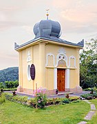
Blue house

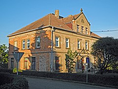
Maxen manor, manor house

Street in Maxen
Old school
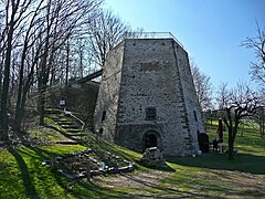
Historic lime kiln

Village church
_Blaues_H%C3%A4usel_Moschee.jpg)


_aus_dem_Jahr_1856_-_geograph.org.uk_-_8840.jpg)

literature
- Series All about Finckenfang , Verlag Niggemann & Simon, Maxen,
- Book 1: The Battle of Maxen on November 20, 1759 by Werner Netzschwitz. Maxen 2004, ISBN 3-9808477-0-5 ,
- Booklet 2: The legendary Müglitztal. Old and new stories from Zinnwald to Heidenau. Maxen 2003, ISBN 3-9808477-1-3 ,
- Book 3: Maxen and his church. Maxen 2003, ISBN 3-9808477-2-1 ,
- Booklet 4: Raden Saleh - A painter's life between two worlds by Werner Kraus. Maxen 2004, ISBN 3-9808477-3-X ,
- Booklet 5: The lime and marble mining around Maxen. Testimony to Juliane Heinze's economic and industrial past . Maxen 2004, ISBN 3-9808477-4-8 ,
- Booklet 6: A farming family in Maxen by Christof Kühnel. Maxen 2004, ISBN 3-9808477-5-6 ,
- Issue 7: Hans Christian Andersen in Dresden and Maxen. Documentation of a friendship between Friederike and Friedrich Anton Serre and Hans Christian Andersen by Lothar Bolze. Maxen 2005, ISBN 3-9808477-7-2 ,
- Booklet 8: Maxen. A village full of history. 2nd edition, Maxen 2006, ISBN 3-9808477-8-0 ,
- Book 9: War and Peace in Maxen by Michael Simon. Maxen 2005, ISBN 3-9808477-9-9 ,
- Booklet 10: The Blue House 1848–2008 by Jutta Tronicke. Maxen 2008, ISBN 978-3-9810717-0-2 ,
- Booklet 11: Döbra and his church, edited by Eva Maria Simon. Maxen 2008, ISBN 978-3-9810717-1-9 (40 pages with 54 illustrations),
- Book 12: Serres and the Artists. Texts, pictures, impressions from the Maxener Talks. Maxen 2009, ISBN 978-3-9810717-2-6 (36 pages with 36 illustrations),
- Booklet 13: "It has been a very unheard-of example to date ..." The finckenfang at Maxen in November 1759 by Michael Simon. Maxen 2009, ISBN 978-3-9810717-3-3 (52 pages with 49 illustrations),
- Issue 14: Chronicle of Maxen, published by the Heimatverein Maxen eV 2nd revised and greatly expanded edition, Maxen 2010, ISBN 978-3-9810717-4-0 (176 pages with 190 images).
- Lothar Bolze: Serres and her friends. Dresden 2000.
- Lothar Bolze: The Maxner Kalk. Dresden 2000.
- History of the natural stage Maxen. Published by the Heimatverein Maxen eV
- Richard Steche : Maxen. In: Descriptive representation of the older architectural and art monuments of the Kingdom of Saxony. 1. Booklet: Official Authority Pirna . CC Meinhold, Dresden 1882, p. 51.
- Maxen. In: Between Tharandter Wald, Freital and the Lockwitztal (= values of our homeland . Volume 21). 1st edition. Akademie Verlag, Berlin 1973, pp. 204–206.
Web links
- Maxen in the Digital Historical Directory of Saxony
- Maxen natural stage
- Heimatverein Maxen
- Blue Mosque
- Maxen Castle
- Maxen Church
Individual evidence
- ↑ Topographic Maps. In: Map viewer: Web-optimized map service from the digital landscape models and house coordinates from the real estate cadastre as WMTS. Staatsbetrieb Geobasisinformation und Vermessung Sachsen, Geodatenservice department, accessed on December 30, 2019 .
- ^ Dresden: location, area, area. State capital Dresden, September 21, 2018, accessed December 30, 2019 .
- ↑ a b c d Explanatory report on the landscape plan of the administrative community Dohna-Müglitztal for the administrative community Dohna-Müglitztal. GICON - Großmann Ingenieur Consult GmbH, March 26, 2018, accessed on December 28, 2019 .
- ↑ a b c WebAtlasSN: Topographic map. In: Geoportal of the Free State of Saxony. Staatsbetrieb Geobasisinformation und Vermessung Sachsen, accessed on January 5, 2020 .
- ↑ a b c topographic maps. In: OpenStreetMap. Stefan Erhardt, Philipp Hochreuther, Martin Schütz, accessed on December 28, 2019 .
- ↑ a b c d e f g Östliches Erzgebirgsvorland (OEV): Technical article on the landscape program - natural space and land use - “Eastern Erzgebirgsvorland” profile. Saxon State Office for Environment, Agriculture and Geology, Section 61 "Landscape Ecology, Area Conservation", accessed on December 29, 2019 .
- ↑ Research of the natural areas and natural area potentials of the Free State of Saxony. Landschaftsforschungszentrum eV, accessed on December 28, 2019 .
- ↑ Map 6: Landscape structure. In: State Development Plan 2013. Saxon State Ministry of the Interior; Saxon State Office for Environment, Agriculture and Geology, July 12, 2013, accessed on December 28, 2019 .
- ↑ Annette Decker: Landscape structure, technical contribution to the landscape program. Saxon State Office for Environment and Geology, Division 61 - Landscape Ecology, Area Conservation, August 30, 2014, accessed on December 29, 2019 .
- ↑ Dietrich Franke: Illustration: regional units of the Saxon Elbe zone depiction without Cenozoic formations. In: Regional Geology of East Germany - A Compendium. 2019, accessed January 3, 2020 .
- ^ Norbert Pflug and Klaus Thalheim: The historical iron ore mining of the Osterzgebirge and Elbe Valley Slate Mountains as reflected in the archives and collections. Senckenberg Natural History Collections Dresden, Museum of Mineralogy and Geology, 2014, accessed on January 3, 2020 .
- ^ Geological overview map. In: Interactive map and map overview of the geological overview map. Saxon State Office for Environment, Agriculture and Geology, 2019, accessed on December 26, 2019 .
- ↑ a b Eckart Frischmuth and Lothar Rudolph: Former "Royal Marble Quarry Maxen" in the Elbe Valley Slate Mountains. In: Geological excursion in the eastern Ore Mountains and its surroundings. Retrieved December 26, 2019 .
- ↑ Jan-Michael Lange: Geology of natural stones in Saxony. Senckenberg Natural History Collections Dresden, Museum of Mineralogy and Geology, Petrography Section, Technical University Berlin (Applied Geosciences), February 2, 2010, accessed on January 2, 2020 .
- ↑ Landscape plan of the administrative association Dohna-Müglitztal: Soil assessment. Großmann Ingenieur Consult GmbH, Verwaltungsgemeinschaft Dohna-Müglitztal, March 8, 2019, accessed on December 29, 2019 .
- ↑ a b Digital soil map 1: 50,000. Saxon State Office for Environment, Agriculture and Geology, 2019, accessed on December 28, 2019 .
- ↑ a b Between Tharandter Wald, Freital and the Lockwitztal (= values of our homeland . Volume 21). 1st edition. Akademie Verlag, Berlin 1973. pp. 204-206
- ↑ a b Map of the landscape plan of the administrative community Dohna-Müglitztal: Water inventory and assessment. Großmann Ingenieur Consult GmbH, March 26, 2028, accessed on December 29, 2019 .
- ↑ a b Climate in Maxen. Climate-Data.org, accessed December 28, 2019 .
- ↑ Landscape plan: Thematic map - Climate and Air Hygiene Assessment, M 1: 25,000. Großmann Ingenieur Consult GmbH, Verwaltungsgemeinschaft Dohna-Müglitztal, March 8, 2019, accessed on December 29, 2019 .
- ↑ Heike Sabel: In the living room of the bats. In: Saxon newspaper. DDV Mediengruppe GmbH & Co. KG, August 21, 2019, accessed on December 17, 2019 .
- ↑ Bat Festival in Maxen Castle. NABU Saxony, accessed on December 27, 2019 .
- ↑ Fauna-flora-habitat areas in Saxony. In: Interactive map. Saxon State Office for Environment, Agriculture and Geology, 2019, accessed on December 28, 2019 .
- ↑ Profiles of the Natura 2000 areas: 4645-302 Separate bat roosts and habitats in the greater Dresden area (FFH area). Federal Agency for Nature Conservation (BfN), September 18, 2019, accessed on December 28, 2019 .
- ↑ Map of the "NATURA 2000 areas in the Free State of Saxony" on a scale of 1: 200.00. Saxon State Office for Environment, Agriculture and Geology, May 19, 2010, accessed on December 28, 2019 .
- ↑ Redevelopment of orchards in the Maxen orchard meadow. Landscape Management Association Saxon Switzerland-Eastern Ore Mountains e. V., accessed on December 29, 2019 .
- ↑ a b c Small-scale community journal. 2011 census. Müglitztal. State Statistical Office of the Free State of Saxony, September 2014, accessed on December 28, 2019 .
- ↑ a b Maxen. Institute for Saxon History and Folklore, accessed on December 28, 2019 .
- ↑ Average age by gender and nationality. Federal Statistical Office (Destatis), August 8, 2019, accessed on December 29, 2019 .
- ↑ Youth quotient in Germany until 2016. Statista GmbH, January 2019, accessed on December 29, 2019 .
Burkhardswalde | Crotta | Falkenhain | Maxen | Mühlbach | Schmorsdorf | Weesenstein