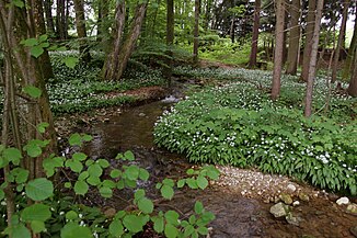
Wolfbauergraben
| Wolfbauergraben | ||
|
Wolfsbauergraben just above the B154 |
||
| Data | ||
| Water code | AT : HZB: 2-122-152-001-012-002 | |
| location | Salzkammergut , Upper Austria | |
| River system | Danube | |
| Drain over | Ramsaubach → Irrsee → Zellerache → Mondsee → Seeache → Attersee → Ager → Traun → Danube → Black Sea | |
| River basin district | Danube below Jochenstein (DUJ) | |
| Beginning | below Staller 47 ° 55 ′ 4 ″ N , 13 ° 20 ′ 12 ″ E |
|
| Source height | 665 m above sea level A. | |
| muzzle | in Ramsau Coordinates: 47 ° 54 '56 " N , 13 ° 18' 53" E 47 ° 54 '56 " N , 13 ° 18' 53" E |
|
| Mouth height | 563 m above sea level A. | |
| Height difference | 102 m | |
| Bottom slope | approx. 49 ‰ | |
| length | approx. 2.1 km | |
| Catchment area | 1.786 km² | |
| Communities | Zell am Moos | |
| ⊙ | ||
The Wolfbauergraben is a small stream on the Zeller- or Irrsee in Mondseeland , part of the Salzkammergut in the Hausruckviertel of Upper Austria .
Run and landscape
The creek rises about 2 kilometers east of the lake on the Riedel , which separates the Haslau from the Irrsee basin, at Staller at about 660 m above sea level. A.
It runs southwest, takes up the trenches from Feichten-Oberlehen , and then flows further westward through a wooded area, the actual Wolfbauergraben.
In Ramsau , 1½ kilometers north of Zell am Moos, at Mondsee Straße (B154), after 2 kilometers from the right, it flows into the Ramsaubach , which comes from Brandstatt and flows a few hundred meters further into the Irrsee.
Geology and hydrography
The brook comes from the marginal moraine of the Dachstein glacier of the Würm Ice Age (approx. 100,000-10,000 years before today), the last glacial period, which left a mighty wall west of the Irree, from the Gommersberg - Schoibernberg -Fuß north to the Lackenberg south is well preserved. Here lies the former tip of the tongue as a Riedel in a characteristic curve, which swings from east near Schweibern to south and strokes in front of the Lackenberg towards Mondsee . At Schweibern there is another Würm moraine, which marks the maximum advance of this time, the Haslau itself was already formed in the previous glacial periods. To the east, the two worm phases have overlapped each other. As a result, the upper Vöckla , coming from Wildmoos above Mondsee behind the Lackenberg, drained through the Haslau to the north towards Frankenmarkt , was completely pushed onto the valley slope of the Saurüsselwald - Glashüttenwald . At the mill in the ditch behind Feichten, the catchment area of the Wolfbauergraben reaches up to 50 meters from the Vöckla. As a result, this moraine ridge also forms the watershed between the Vöckla and the Ager , to which the Irrsee belongs (via Attersee and Mondsee), the two only meet again in Vöcklabruck.
In the actual Wolfbauergraben, the brook breaks through further marginal moraines of various retreat stages, which lie here in the room in up to six seasons down to the lake.
Web links
Individual evidence
-
↑ a b c d e f g h HZB-Code 2-122-152-001-012-002 Wolfbauergraben - right feeder to the Ramsaubach ;
Stationing points (1000 m) from the mouth to km 2 about 80 meters below the hydrographic origin;
Information about DORIS , topic water & geology , information about detailed catchment areas and stationing 1000 m , doris.ooe.gv.at - ↑ Gustav Görzinger: 1959 report on recordings on the Straßwalchen sheet (64) . In: Negotiations of the Federal Geological Institute 1960, Quaternary section : Zellerseer branch of the Traungletscher , p. A 38 ( full article p. A 36–38, pdf , opac.geologie.ac.at).
