
Wolf Lows
|
Wolf Lows
City of Bergisch Gladbach
Coordinates: 50 ° 58 ′ 27 ″ N , 7 ° 13 ′ 3 ″ E
|
||
|---|---|---|
Location of Wolfsiefen in Bergisch Gladbach |
||
 Half-timbered house in Wolfsiefen
|
||

Wolfsiefen is a district in the Bärbroich district of Bergisch Gladbach .
history
The settlement name Wolfsiefen is modern and refers to the former occurrence of wolves, which were still at home in the vast forests around Bensberg until the 19th century . A Siefen is a narrow, ravine-like forest valley with a small trickle. The place is not recorded in the original cadastre .
According to the overview of the government district of Cöln , the place categorized as “farm goods” had two houses in 1845. At that time there were ten people living in the village, all of them Catholic. The spelling of the place name at that time was Wolfseifen.
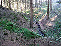
Siefen
To the south and south-east of Wolfsiefen lie the three springs from which Dreispringen owes its name. From every source there is a source depth. They run towards each other like a fork and unite about 50 meters before they reach the valley. This brook then flows into the Kotzbach .
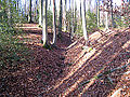
Western spring depths

Medium source depths
Eastern spring depths
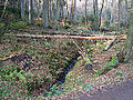
The brook crosses under the Juckerberg street and then flows into the Kotzbach.


Mining
The two large mines Grube Apfel and Grube Berzelius were located immediately to the west of Wolfsiefen .
Individual evidence
- ^ Andree Schulte: Bergisch Gladbach City History in Street Names , published by the Bergisch Gladbach City Archives, Volume 3, and by the Bergisch Geschichtsverein department Rhein-Berg e. V., Volume 11, Bergisch Gladbach 1995, p. 225 ISBN 3-9804448-0-5
- ↑ Overview of the components and list of all the localities and individually named properties of the government district of Cologne: by districts, mayor's offices and parishes, with information on the number of people and the residential buildings, as well as the Confessions, Jurisdictions, Military and former state conditions. / ed. from the Royal Government of Cologne [Cologne], [1845]