
Triple jump
|
Triple jump
City of Bergisch Gladbach
Coordinates: 50 ° 58 ′ 44 ″ N , 7 ° 12 ′ 39 ″ E
|
||
|---|---|---|
| Height : | 235-255 m above sea level NHN | |
Location of Dreispringen in Bergisch Gladbach |
||
 Triple jump
|
||

Dreispringen is a district in the Bärbroich district of Bergisch Gladbach . Since 1962 it has consisted of the two localities Oberdreispringen and Unterdreispringen .
location
The Dreispringen location is in the east of the city of Bergisch Gladbach at an altitude of about 235 m above sea level. NHN to 255 u m. NHN . A little above, next to a radio mast, is the trigonometric point II. Order three-jump location , vis-à-vis the house Ottoherscheid 76 a at a height of 266.8 m above sea level. NHN . At 267 m above sea level NHN , the ridge represents the highest elevation of the Bärbroicher Höhe .
history
The Dreispringen settlement is not yet recorded in the original cadastre . As a result, it did not emerge until after 1828 in the middle of the 19th century through the emerging coal and steel industry .
According to the survey of the government district of Cöln , the place categorized as "farms" had three houses in 1845. At that time there were 17 residents, all of them Catholic. In 1905 Dreispringen already had eleven buildings and 57 residents. The name of the settlement Dreispringen literally means three springs . It is derived from the Old High German "springan" (= spring, spring, gush) or the Middle High German "sprinc" (= source). The headwaters at the top have three small watercourses that merge a little further east to form the Kotzbach .
Three sources gave it its name
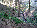
There are several possible locations for the three springs from which Dreispringen owes its name. Possibly it is the springs that are halfway up the southeast slope of the Dreispringer Berg near Wolfsiefen . From every source there is a source depth. They run towards each other like a fork and unite about 50 meters before they reach the valley. This creates a small stream, which then flows into the Kotzbach.
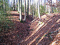
Western spring depths

Medium source depths
Eastern spring depths
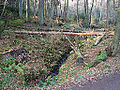
The brook crosses under the street Juckerberg and then flows into the Kotzbach.


Mining
The two large mines Grube Berzelius and Grube Apfel were located on the western slope of the ridge .
Individual evidence
- ^ A b c Andree Schulte: Bergisch Gladbach city history in street names , published by the Bergisch Gladbach City Archives, Volume 3, and by the Bergisches Geschichtsverein department Rhein-Berg e. V., Volume 11, Bergisch Gladbach 1995, p. 222 f. ISBN 3-9804448-0-5
- ^ Rudolph Schmidt: The triangulation in North Rhine-Westphalia. Land survey office of North Rhine-Westphalia, Godesberg 1962, p. 144, triangulation from 1889/1892.
- ↑ Information on location and height from tim-online.nrw.de , accessed on December 12, 2014.
- ↑ Overview of the components and list of all the localities and individually named properties of the government district of Cologne: by districts, mayor's offices and parishes, with information on the number of people and the residential buildings, as well as the Confessions, Jurisdictions, Military and former state conditions. / ed. from the Royal Government of Cologne [Cologne], [1845]