Broichhausen (Rhein-Berg)
Broichhausen is a village that has parts in the urban area of Bergisch Gladbach as well as in the municipality of Kürten .
Location description
Broichhausen (Bergisch Gladbach)
The smaller part of the village of Broichhausen is located south of Landstrasse 298 in the area of the Bärbroich district in Bergisch Gladbach. This part is also called Oberbroichhausen .
Broichhausen (Kürten)
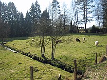
The larger and older part of the village of Broichhausen (Kürten) is located north of the road 298 in the area of the municipality of Kürten. This part is also called Unterbroichhausen . Here the Silberkauler Siefen flows into the Dürschbach .
history
The Broichhausen settlement dates back to a medieval hamlet . It was first mentioned in 1356 as "Brohusen" . In the original cadastre the settlement is mentioned in the plural with the ending "hausen" , from which it can be concluded that it was initially a collective settlement with several farms.
According to the survey of the government district of Cöln , the place categorized as “farm goods” and mill had two houses in 1845. At that time 19 people lived in the village, all of them Catholic faith. In the list of the Kingdom of Prussia for the 1885 census, Broichhausen was listed as the residential area of the rural community of Bensberg in the Mülheim am Rhein district. At that time there were 7 houses with 40 inhabitants. In 1905 there were ten buildings with 55 residents.
The Broichhausen mill was powered by water from the Silberkauler sieve. It was still in use until 1957. Some time later it was leveled by a bulldozer . Parts of the foundation walls and parts of the mill shaft from which the mill wheel was driven have been preserved.
See also
Individual evidence
- ↑ Stephan Brockmeier: Clean water for Broichhausen . In: Kölnische Rundschau . ( rundschau-online.de [accessed on March 2, 2017]).
- ↑ Overview of the components and list of all the localities and individually named properties of the government district of Cologne: by districts, mayor's offices and parishes, with information on the number of people and the residential buildings, as well as the Confessions, Jurisdictions, Military and former state conditions. / ed. from the Royal Government of Cologne [Cologne], [1845]
- ^ Community encyclopedia for the province of Rhineland. Based on materials from the census of December 1, 1885 and other official sources, edited by the Royal Statistical Bureau. In: Royal Statistical Bureau (Hrsg.): Community encyclopedia for the Kingdom of Prussia. tape XII , 1888, ZDB -ID 1046036-6 ( digitized version ).
- ^ Andree Schulte: Bergisch Gladbach City History in Street Names , published by the Bergisch Gladbach City Archives, Volume 3, and by the Bergisch Geschichtsverein department Rhein-Berg e. V., Volume 11, Bergisch Gladbach 1995, p. 219 ISBN 3-9804448-0-5
Coordinates: 51 ° 0 ' N , 7 ° 13' E

