Steeg (Kürten)
|
Steeg (Kürten)
Kurten municipality
Coordinates: 51 ° 0 ′ 45 ″ N , 7 ° 13 ′ 18 ″ E
|
||
|---|---|---|
| Height : | 170 m | |
| Area : | 4.86 km² | |
| Postal code : | 51515 | |
| Area code : | 02207 | |
|
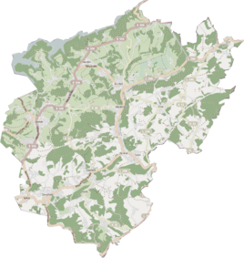
Location of Steeg (Kürten) in Kürten |
||
|
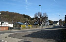
Steeg on Wipperfürther Strasse
|
||
Steeg is a district in the municipality of Kürten in the Rheinisch-Bergisches Kreis .
Visually, Steeg forms a joint settlement area with the neighboring district of Dürscheid to the west . Both are connected with each other as a church location of the Catholic Church . Nevertheless, until the Cologne Act came into force on January 1, 1975, the city boundary between the former city of Bensberg and the municipality of Kürten ran between the two places .
history
The Steeg farm was mentioned in a document as early as the turn of the 14th century , when Engelbert von dem Bottlenberg, the commander of the Johanniter at Burg Castle, sold rents to his farm near Dürscheid.
The Topographia Ducatus Montani by Erich Philipp Ploennies from 1715, Blatt Amt Steinbach , shows that the place already consisted of three courtyards in 1715, which are labeled as a footbridge . Carl Friedrich von Wiebeking names the court on his charter of the Duchy of Berg in 1789 as a footbridge . It shows that Steeg was part of the Engelsdorf community in the parish of Kürten at that time .
Under the French administration between 1806 and 1813, the Steinbach office was dissolved and Steeg was politically assigned to the Mairie Kürten in the canton of Wipperfürth . In 1816 the Prussians converted the Mairie to the mayor's office in Kürten in the Wipperfürth district .
The place is recorded on the topographical survey of the Rhineland from 1824 and on the Prussian first survey of 1840 as Steeg . From the Prussian new admission in 1892, it is regularly listed as Steeg on measuring table sheets .
In 1822, 46 people lived in the place, which was categorized as a courtyard and called a footbridge . The place categorized as a hamlet according to the overview of the government district of Cologne in 1845 had twelve houses at that time. At that time, 86 people lived in the village, 81 of them Catholic and five Protestant. The municipality and estate district statistics of the Rhine province are listed by Steeg in 1871 with 14 houses and 103 inhabitants. In the municipality lexicon for the Rhineland province of 1888, 18 houses with 117 inhabitants are given. In 1895 19 houses with 106 inhabitants are given, in 1905 the place has 16 houses and 108 inhabitants and belonged denominationally to the Catholic parish of Dürscheid .
Due to the Cologne Law, the municipality of Kürten was merged with the previously independent municipalities of Bechen and Olpe to form the large municipality of Kürten with effect from January 1, 1975 . In the process, peripheral areas were also outsourced from the city of Bensberg and incorporated into Kürten. In this way, the immediately neighboring Bensberger Dürscheid , across the border marking the Weyerbach and Dürschbach , also came into the municipality. Over time, the vacant lots between the two places closed, so that today both form a closed settlement area.
See also
Individual evidence
- ↑ Street names of the municipality of Kürten, place and hamlet names No. 40 , published by the history association for the municipality of Kürten and the surrounding area, accessed on March 31, 2017
- ^ Parish St. Marien Kürten - Our parish accessed on March 26, 2017
- ↑ Law on the reorganization of the municipalities and districts of the Cologne reorganization area ( Cologne Law ) of November 5, 1974, § 2 and § 11
- ↑ Albrecht Brendler: On the way to the territory. Administrative structure and office holder of the County of Berg 1225–1380. Dissertation University of Bonn, 2015.
- ^ Wilhelm Fabricius : Explanations for the Historical Atlas of the Rhine Province ; Second volume: The map of 1789. Division and development of the territories from 1600 to 1794 ; Bonn; 1898
- ↑ Alexander A. Mützell: New topographical-statistical-geographical dictionary of the Prussian state . tape 3 . Karl August Künnel, Halle 1822.
- ↑ Overview of the components and list of all the localities and individually named properties of the government district of Cologne: by districts, mayor's offices and parishes, with information on the number of people and the residential buildings, as well as the Confessions, Jurisdictions, Military and former state conditions. / ed. from the Royal Government of Cologne [Cologne], [1845]
- ↑ Royal Statistical Bureau Prussia (ed.): The communities and manor districts of the Prussian state and their population . The Rhine Province, No. XI . Berlin 1874.
- ↑ Königliches Statistisches Bureau (Prussia) (Ed.): Community encyclopedia for the Rhineland Province, based on the materials of the census of December 1, 1885 and other official sources, (Community encyclopedia for the Kingdom of Prussia, Volume XII), Berlin 1888.
- ↑ Königliches Statistisches Bureau (Prussia) (Ed.): Community encyclopedia for the Rhineland Province, based on the materials of the census of December 1, 1895 and other official sources, (Community encyclopedia for the Kingdom of Prussia, Volume XII), Berlin 1897.
- ↑ Royal Statistical Bureau (Prussia) (Ed.): Community encyclopedia for the Rhineland Province, based on the materials of the census of December 1, 1905 and other official sources, (Community encyclopedia for the Kingdom of Prussia, Volume XII), Berlin 1909

