Broichhausen (Kürten)
|
Broichhausen
Kurten municipality
Coordinates: 50 ° 59 ′ 58 ″ N , 7 ° 13 ′ 26 ″ E
|
||
|---|---|---|
| Postal code : | 51515 | |
| Area code : | 02207 | |
|
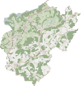
Location of Broichhausen in Kürten |
||
|
Unterbroichhausen
|
||
Broichhausen is a residential area in the southwest of the municipality of Kürten on the border with Bergisch Gladbach .
Location and description
Broichhausen is located in the Dürschbachtal along the state road 298. In Broichhausen the Silberkauler Siefen flows into the Dürschbach. In the neighborhood are the Gladbach part of Broichhausen in the south and Jähhardt , separated by a forest, in the north.
history
The name Broichhausen means, according to the interpretation of the local history association, houses in or on marshy terrain . Colloquially, one speaks of om Brooches.
The first written mention of a mill and farm in Broichhausen comes from the year 1586. It is assumed that the property belongs to the Johanniterkomturei Herrenstrunden . At that time Broichhausen belonged to the Dürscheid honors in the Herkenrath messenger office in the Bergisch office of Porz .
The Topographia Ducatus Montani by Erich Philipp Ploennies , Blatt Amt Porz , proves that the Bruchhausen had two residential spaces with a courtyard each, which are labeled as Bruchhusen as early as 1715 . There is also a mill on the Dürschbach . From the chart of the Duchy of Berg from 1789 by Carl Friedrich von Wiebeking, it emerges that the local area was at that time part of the parish Dürscheid in the upper court of Bensberg of the Bergisch office of Porz .
In the topographical survey of the Rhineland from 1824, the place is recorded as Bruchhausen , as well as in the Prussian first recording from 1845. From the Prussian new recording 1891–1912, the place is regularly marked as Broichhausen .
Under the French administration between 1806 and 1813, the Porz office was dissolved and the parish Dürscheid, to which Broichhausen also belonged, was politically assigned to the Mairie Bensberg in the Mülheim am Rhein arrondissement . In 1816 the Prussians converted the Mairie to the mayor's office in Bensberg in the Mülheim am Rhein district . In 1822, 17 people lived in the village, which was categorized as a farm with a mill, in 1830 the village had 21 inhabitants.
The municipality and estate district statistics of the Rhine Province show Broichhausen 1871 with six houses and 48 inhabitants. In the list of the Kingdom of Prussia for the 1885 census, Broichhausen was noted as the residential area of the rural community of Bensberg in the Mülheim am Rhein district. At that time there were seven houses with 40 inhabitants.
Due to the Cologne Act , the municipality of Kürten was merged with the previously independent municipalities of Bechen and Olpe and parts of the city of Bensberg to form the municipality of Kürten with effect from January 1, 1975 . It was also the north of the L 298 located part of Broichhausen even lower Broichhausen called , part of Kurten. The part south of the L 298, called Oberbroichhausen , became part of the city of Bergisch Gladbach.
The Broichhausen mill
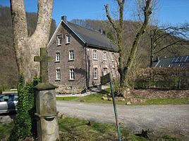
The Broichhausen watermill , first mentioned in 1586, had two grinding courses and was also mentioned in the documents in 1697, 1732 and 1766. In 1697 an Anton Molitor ( Molitor = lat. Müller ) is named as Müller. The mill burned down in 1843, but was rebuilt by 1851. After the waterwheel was renewed in 1920, it was shut down in 1957.
See also
Individual evidence
- ↑ Stephan Brockmeier: Clean water for Broichhausen . In: Kölnische Rundschau . ( rundschau-online.de [accessed on March 2, 2017]).
- ↑ a b Ute Ströbel-Dettmer: Broichhausener mill near Dürscheid. Municipality of Kürten, accessed on April 21, 2017 .
- ↑ Street names of the municipality of Kürten. (PDF) History Association for the Municipality of Kürten and Surroundings e. V., accessed April 8, 2017 .
- ^ Wilhelm Fabricius : Explanations for the Historical Atlas of the Rhine Province ; Second volume: The map of 1789. Division and development of the territories from 1600 to 1794 ; Bonn; 1898
- ↑ Alexander A. Mützell: New topographical-statistical-geographical dictionary of the Prussian state . tape 1 . Karl August Künnel, Halle 1821.
- ^ Friedrich von Restorff: Topographical-statistical description of the Royal Prussian Rhine Provinces , Berlin and Stettin, 1830
- ↑ Royal Statistical Bureau Prussia (ed.): The communities and manor districts of the Prussian state and their population . The Rhine Province, No. XI . Berlin 1874.
- ↑ Königliches Statistisches Bureau (Prussia) (Ed.): Community encyclopedia for the Rhineland Province, based on the materials of the census of December 1, 1885 and other official sources, (Community encyclopedia for the Kingdom of Prussia, Volume XII), Berlin 1888.
- ↑ a b Herbert Nicke : Bergische Mühlen. On the trail of the use of hydropower in the land of a thousand mills between Wupper and Sieg . Galunder, Wiehl 1998, ISBN 3-931251-36-5 , pp. 264 .

