Wollenberg (Rhenish Slate Mountains)
| Wollenberg | ||
|---|---|---|
|
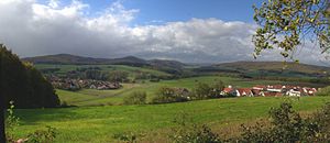
View from the Rimberg Tower (from the southwest) to the Wollenberg |
||
| height | 474 m above sea level NN | |
| location | Lahn valley and weather , district of Marburg-Biedenkopf | |
| Mountains | Bagpipe forecrops , East Sauerland mountain range | |
| Coordinates | 50 ° 52 '36 " N , 8 ° 40' 3" E | |
|
|
||
| rock | Upper Devonian , Lower Carboniferous | |
| particularities | Remains of the Eckelskirche castle | |
|
View from the southeast of the Wollenberg (right); to the left follow the Damshauser peaks Feiselberg (413 m), Rimberg (498 m) and Hungert (412 m) |
||
The Wollenberg is a 474 m high, completely forested mountain in the Marburg-Biedenkopf district , Hesse . It is one of the easternmost mountains of the Rhenish Slate Mountains . Eckelskirche Castle was once located on its highest peak , of which only remains are left today.
location

The 14 km² large state forest Wetter-West rises southwest of Wetter . The mountain consists of the three main peaks Norn ( 422 m above sea level ) in the north and the southern Wollenberg (467 m) and Eckelskirche (474 m - with sparse remains of the Eckelskirche castle ). It towers above the Wetteraner Oberstadt by around 200 m and the well-known Christenberg (387 m) near Münchhausen by almost 90 m. The forest area is framed by the villages of Wetter, Amönau and Oberndorf in the north, Warzenbach in the west and the Lahntaler districts of Brungershausen in the south-west, Caldern (-Nord) in the south and Sterzhausen in the south-west.
Natural allocation
The Wollenberg is the (south-) easternmost of the bagpipe forecrops that roof the Rothaargebirge to the east around the 674-meter-high bagpipe and, as part of the East Sauerland mountain range, form the eastern border of the southern mountainous region and the Rhenish slate mountains .
The Wollenberg is connected to the actual bagpipe foreshore to the west by a narrow, wooded corridor to the west to the 460 m high Homberg , while to the north and east it is enclosed by the Wetschaft depression , which introduces the Burgwald and thus the West Hessian mountains . To the southwest, its flank meets the Obere Lahn valley .
In the Handbook of the Natural Spatial Structure of Germany , the mountain was still assigned to the Gladenbacher Bergland in 1957, as was a large part of the foothills adjoining it to the west, but this was corrected in the individual sheet Marburg of the same institute.
Geologically, the Wollenberg is the northeasternmost mountain in the Hörre zone , which is almost entirely in the Gladenbacher Bergland, but extends to the southeast into the actual Westerwald .

View of the Rothaargebirge with the bagpipe (674 m) and its foothills Arennest (592 m), Kohlenberg (583 m) and Wollenberg (474 m) in the north. On the far right in the background the Kellerwald, 35 km away, with the Hohen Lohr (657 m) and the desert garden (675 m).
|
Individual evidence
- ^ E. Meynen and J. Schmithüsen : Handbook of the natural spatial structure of Germany - Federal Institute for Regional Studies, Remagen / Bad Godesberg 1953–1962 (9 deliveries in 8 books, updated map 1: 1,000,000 with main units 1960)
- ↑ Gerhard Sandner: Geographical Land Survey: The natural space units on sheet 125 Marburg - Federal Institute for Regional Studies, Bad Godesberg 1960 → online map
- ↑ Map and legend of the natural areas of Hesse (online copy of Die Naturraum Hessens , Otto Klausing 1988) in the Hessen Environmental Atlas of the Hessian State Office for Environment and Geology
- ↑ Interactive map and legend on the geological structure of Hesse in the Hesse Environmental Atlas of the Hessian State Office for Environment and Geology


