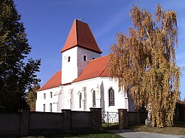
Wolteritz
|
Wolteritz
City of Schkeuditz
Coordinates: 51 ° 27 ′ 6 ″ N , 12 ° 20 ′ 8 ″ E
|
||
|---|---|---|
| Residents : | 280 (March 1, 2018) | |
| Incorporation : | March 1, 1994 | |
| Incorporated into: | Radefeld | |
| Postal code : | 04435 | |
| Area code : | 034207 | |
|
Location of Wolteritz in Saxony |
||
Wolteritz is a district of the city of Schkeuditz in the northern Saxony district .
geography
Wolteritz is located in the Leipzig lowland bay north of Leipzig am Lober . In the south of the village lies the Schladitzer See , in the northwest of the Werbeliner See , both of which were created as a result of the renaturation of the Delitzsch-Südwest / Breitenfeld opencast mine .
history
Wolteritz, like its later district of Lössen, belonged to the electoral office of Delitzsch until 1815 . As a result of the resolutions of the Congress of Vienna , the place became part of Prussia and was assigned to the Delitzsch district in the Merseburg administrative district of the province of Saxony in 1816, to which it belonged until 1952. On July 1, 1950, the neighboring village of Lössen to the southeast was incorporated . In the course of the district reform in the GDR in 1952, Wolteritz was assigned to the newly tailored Delitzsch district in the Leipzig district.
With the opening of the Delitzsch-Südwest opencast mine northwest of Wolteritz in 1975/76, the future of the place became uncertain. The village was in the planned mining area and was earmarked for resettlement in the early 1990s. The same fate met the district of Lössen, which the Breitenfeld opencast mine opened in 1981/82 with the Wolteritz pivot point approached from a south-westerly direction. While the resettlement and subsequent devastation of Lössen took place in 1985 and ended in the demolition in 1988, Wolteritz was spared this fate due to the German reunification in 1989/90. The sudden reduction in the demand for lignite as a result of the political and economic turnaround led to the early closure of the Breitenfeld (1991) and Delitzsch-Südwest (1993) opencast mines, which meant that the planned relocation and devastation of Wolteritz was no longer carried out.
On March 1, 1994, Wolteritz was merged with Freiroda and Radefeld to form the new municipality of Radefeld and allocated to the district of Delitzsch . Since January 1, 1999, the municipality of Radefeld has belonged to the town of Schkeuditz, which was moved to the district of Delitzsch, which means that Wolteritz has been part of this town since then. In 1998, the two remaining open-cast mine holes around Wolteritz began to be flooded, which means that the place is now between Lake Werbeliner in the north-west and Lake Schladitzer in the south.
traffic
Wolteritz is located north of the federal motorway 14 (Dresden - Magdeburg). The motorway junctions 21 Schkeuditz and 22 Leipzig-Nord can be reached quickly from the location . Bundesstraße 184 runs northeast of Wolteritz .
Between 1929 and 1970 the place was connected to the Delitzscher Kleinbahn via the stop "Wolteritz" (originally called "Lössen") .
literature
- Manfred Wilde : The Lost Places of the Delitzsch District. On the settlement and social history of the villages of Grabschütz , Kattersnaundorf , Kömmlitz , Lössen , Paupitzsch , Schladitz , Seelhausen , Werbelin and Wolteritz . Sax-Verlag, Beucha 1999
- Angelika Hofmann: Keeping history alive - exquisite, experienced, experienced. Attempt to create a chronicle of Wolteritz and Lössen. Edition digital, Pinnow 2020, ISBN 978-3-96521-175-9 .
Web links
Individual evidence
- ^ Karlheinz Blaschke , Uwe Ulrich Jäschke : Kursächsischer Ämteratlas. Leipzig 2009, ISBN 978-3-937386-14-0 ; P. 56 f.
- ^ The district of Delitzsch in the municipality register 1900
- ↑ Lössen in the Historical Directory of Saxony
- ↑ Lössen on www.genealogy.net
- ↑ Wolteritz and Lössen on gov.devastiert.de ( Memento of the original from December 8, 2015 in the Internet Archive ) Info: The archive link was automatically inserted and not yet checked. Please check the original and archive link according to the instructions and then remove this notice.


