Worthington, Minnesota
| Worthington | |
|---|---|
 10th Street in downtown Worthington (2007). |
|
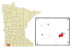
| Location in Minnesota | |
| Basic data | |
| State : | United States |
| State : | Minnesota |
| County : | Nobles County |
| Coordinates : | 43 ° 37 ′ N , 95 ° 36 ′ W |
| Time zone : | Central ( UTC − 6 / −5 ) |
| Residents : | 12,764 (as of 2010) |
| Population density : | 689.9 inhabitants per km 2 |
| Area : | 22.0 km 2 (approx. 8 mi 2 ) of which 18.5 km 2 (approx. 7 mi 2 ) is land |
| Height : | 485 m |
| Postal code : | 56187 |
| Area code : | +1 507 |
| FIPS : | 27-71734 |
| GNIS ID : | 0654391 |
| Website : | www.ci.worthington.mn.us |
| Mayor : | Alan Oberloh |
 Nobles County Courthouse |
|
Worthington is a city (with the status " City ") and the administrative center of the Nobles County in the US -amerikanischen State Minnesota . In 2010 Worthington had 12,764 residents.
Worthington was founded in the 1870s under the name Okabena Station, a stop on the Chicago, St. Paul, Minneapolis and Omaha Railway between the Twin Cities and Omaha . The location on Lake Okabena provided the steam-powered locomotives with a convenient location to fill their water tanks. Only later was it renamed Worthington.
Worthington has had a town twinning with Crailsheim since 1947 , which was the first German-American town twinning ever.
geography
According to the United States Census Bureau , the city has an area of 22 km², of which 18.5 km² is land and 3.5 km² (= 16.10%) is water.
The Worthington area runs through Interstate 90 , US Highway 59, and Minnesota State Route 60 .
Worthington is in Minnesota's 1st congressional electoral district .
Demographic data
| Population development | |||
|---|---|---|---|
| Census | Residents | ± in% | |
| 1880 | 636 | - | |
| 1890 | 1164 | 83% | |
| 1900 | 2386 | 105% | |
| 1910 | 2385 | -0% | |
| 1920 | 3481 | 46% | |
| 1930 | 3878 | 11.4% | |
| 1940 | 5918 | 52.6% | |
| 1950 | 7923 | 33.9% | |
| 1960 | 9015 | 13.8% | |
| 1970 | 9916 | 10% | |
| 1980 | 10,243 | 3.3% | |
| 1990 | 9977 | -2.6% | |
| 2000 | 11,283 | 13.1% | |
| 2010 | 12,764 | 13.1% | |
| 1880-2000 2010 | |||
According to the 2010 census , Worthington had 12,764 people in 4,458 households. The population density was 689.9 people per square kilometer. Statistically, there were 2.79 people each in the 4,458 households.
The racial the population was composed of 62.2 percent white, 5.5 percent African American, 0.7 percent Native American, 8.6 percent Asian, 0.2 percent Polynesian and 20.5 percent from other ethnic groups; 2.4 percent were descended from two or more races. Regardless of ethnicity, 35.4 percent of the population was Hispanic or Latino of any race.
26.8 percent of the population were under 18 years old, 58.2 percent were between 18 and 64 and 15.0 percent were 65 years or older. 48.9 percent of the population was female.
The average annual income for a household was 42,472 USD . The per capita income was $ 19,435. 26.8 percent of the population lived below the poverty line.
Known residents
- George Dayton (1857–1938) was a banker here before settling in Minneapolis and opening Dayton's Department Store (now part of Macy’s ). His house from 1890 has since been renovated.
- Tim O'Brien (* 1946) - author best known for his novels about the aftermath of the Vietnam War , grew up here in the 1950s. He makes reference to Worthington in several of his works, including The Things They Carried (1990).
Individual evidence
- ↑ a b c American Fact Finder. Retrieved May 29, 2013
- ↑ About Worthington ( Memento of the original from November 24, 2007 in the Internet Archive ) Info: The archive link was automatically inserted and not yet checked. Please check the original and archive link according to the instructions and then remove this notice. (accessed February 15, 2008)
- ^ US Decennial Census. Retrieved May 29, 2013
