
Y-route (rapid cycle connection)
The Y-route (RSV 1) is a planned rapid cycle connection in Berlin . The construction phase is not expected to start before 2022 . The designation Y-route is based on the Y-shaped route. The final name is still up for discussion.
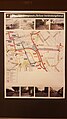
The route should extend over a total length of around 17 kilometers and run through the districts of Treptow-Köpenick , Neukölln and Friedrichshain-Kreuzberg .
history

In 2017, 30 so-called 'route corridors' were identified in Berlin that could be suitable for the construction of cycle superhighways. Investigations into concrete possible courses were started for ten of these routes. According to § 45 of the 2018 from the Berlin House of Representatives adopted mobility law Radschnellverbindungen to be built with a total length of at least 100 kilometers in Berlin. The state-owned company infraVelo was founded for the implementation .
On April 16, 2019, the District Mayor of Friedrichshain-Kreuzberg, Monika Herrmann ( Bündnis 90 / Die Grünen ), the District Mayor of Neukölln, Martin Hikel ( SPD ), the State Secretary for Transport, Ingmar Streese , and Peter Bischoff from the planning office SHP Engineers in front of about 150 visitors in the home port of Neukölln . Part of the event was a dialogue between citizens and interested parties and the responsible planning office about a possible course of the route. In four discussion groups, the participants were able to contribute to possible specific road course options in four different route areas. The suggestions made there are to be included in the further planning.
Sections
The probable route is divided into three sections from south to north:
Section I (from Adlershof to Hafen Britz-Süd)
Section I, starting from Adlershof, is to run over a distance of around 5.7 kilometers over the Berlin Wall Trail parallel to the federal motorway 113 to the Britz-Süd port, where the route forks into two sections. The planned section leads away from the car traffic on a separate cycle route. Driving the route should take around 36 minutes at medium speed and around 22 minutes at high speed. The section would connect the new residential area in Johannisthal and the Humboldt University in Adlershof to the city center. The responsible planning office SHP expects that the route section could replace around 300 car journeys a day.
Section II (from Neukölln to Südstern)
Section II is the western arm of the route and, as a connection between Neukölln and Kreuzberg, runs along Tempelhofer Feld , through Volkspark Hasenheide to Südstern and connects the new residential areas Luisenstadt Mariendorfer Weg / Tempelhofer Weg. The section should be around 5.9 kilometers long and can be covered in around 24 minutes at a medium speed and around 16 minutes at high speeds. According to the SHP, it should be able to replace up to 2200 car journeys a day.
Section III (from Neukölln to Görlitzer Park)
Section III is the eastern junction, which is expected to lead along the Bundesautobahn 100 or the Teltow Canal on the Wall Trail to Görlitzer Park and will be around five kilometers long. The arm should form a connection to the Wall Trail and the European Cycle Route R1 . Depending on the speed, it should be possible to cover it in around 27 or 16 minutes of driving time. In particular due to the residential areas and workplaces located there, the planning office reckons with around 3,100 car journeys saved on this section.
- Individual route areas with possible routes in the discussion

Hasenheide / Oderstrasse

Görlitzer Bahnhof / service route A 100

Service route A 113
Delfter Ufer / Rungiusstrasse / Britzer connecting canal


See also
Web links
- Y-route at infravelo.de
Individual evidence
- ↑ Peter Neumann: Teltow Canal Route: This is how cyclists should get through the city faster. February 1, 2019, accessed February 2, 2019 .
- ↑ Gudrun Mallwitz: Y-Trasse in Berlin: This is the route of the planned cycle expressway. April 17, 2019, accessed April 28, 2019 .
Y-route (RSV 1) | Mitte - Tegel - Spandau (RSV 2) | Königsweg - Kronprinzessinnenweg (RSV 3) | Panke Trail (RSV 4) | West Route (RSV 5) | Teltow Canal Route (RSV 6) | Spandauer Damm - Freedom (RSV 7) | Nonnendammallee - Falkenseer Chaussee (RSV 8) | Landsberger Allee - Marzahn (RSV 9) | Heiligensee (extension of route 2) (RSV 10) | Tangential connection east