Yaquina Head
| Yaquina Head | ||
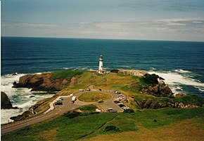
 Yaquina Head peninsula with the lighthouse, view from Salal Hill |
||
| Geographical location | ||
|
|
||
| Coordinates | 44 ° 40 '36 " N , 124 ° 4' 44" W | |
| Waters 1 | Pacific Ocean | |
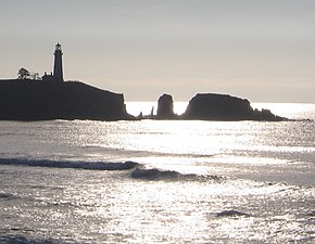
 Yaquina Head as seen from the north. |
||
Yaquina Head is a peninsula on the west coast of the United States north of Newport , Oregon in Lincoln County . The name comes from an Indian tribe that lived on the Oregon coast and is now practically extinct. At the tip of the peninsula is the Yaquina Head Lighthouse . Parts of the approximately 1.3 km long peninsula have been under the protection of the Bureau of Land Management as Outstanding Natural Area since 1948 .
The relatively straight course of the central and northern coastline off Oregon is interrupted by individual peninsulas, the headlands . The Yaquina Head Peninsula forms the northern limit of such a bay, which begins at Yaquina Bay , the mouth of the Yaquina River near Newport. The peninsula is dominated by the Yaquina Head Lighthouse , built between 1871 and 1873 . There are some small islands with bird colonies in front of it.
geology
Yaquina Head was formed from the Columbia Plateau basalt between 17 and 14 million years ago. The flood basalts come from the region east of the Cascade Mountains from the border region of Oregon, Idaho and Washington . On their approximately 500 km long way to the west, the huge amounts of lava followed the Columbia River in its valley through the Cascade Mountains to the sea. As a result, the Columbia River was repeatedly forced to abandon its old river bed in the course of its history because it was displaced by massive basalt currents, it looked for new paths and formed new valleys through erosion . Hoper found that the mouth of the Columbia River was further south about 15 million years ago. Through this former river valley, part of the so-called Gingko basalt flow reached the coast of Oregon and formed a basalt peak in the sea, the Yaquina Head.
As it reached the Pacific Ocean, the lava eventually cooled and came to a standstill. Around Portland , the lava flow split, another part of the lava reached the Pacific Ocean about 250 km further north at Astoria , at what is now the mouth of the Columbia River. Below the basalt layer there are further deposits, partly from volcanic ash , basalt , sandstone or mudstone , depending on the origin.
From the sedimentary deposits that were formed below the sea floor, but now occur in terraces in some places on the coastline and at Yaquina Bay above sea level, it can be concluded that the land has risen sharply over the past two million years.
Since the basalt that is predominant at Yaquina Head is more resistant to sea erosion than the surrounding plateau sediments , the basalt structure was retained as a peninsula. In contrast, the surrounding cliffs have been much more eroded. Erosion, folding and uplift brought the peninsula into its present form.
use
At the beginning of this century, parts of the basalt at Yaquina Head were mined for road construction, especially for the expansion of the nearby US Highway 101 . In 1939 the lighthouse was electrified, automated in 1966 and in 1980 the entire Yaquina Head peninsula was placed under nature protection. There is a fee to visit the peninsula, and some hiking trails and viewpoints have been created. Yaquina Head is a popular lookout point for observing gray whales on their migrations. In winter, these migrate from the waters off Alaska to the Gulf of California along the American west coast . Between March and May they move north again.
literature
- PD Snavely Jr., NS Macleod: Visitor's Guide to the geology of the coastal area near Beverly Beach State Park, Oregon . In: The Ore Bin . tape 33 , no. 5 , 1971 (English, oregongeology.org [PDF; 2.7 MB ; accessed on February 5, 2010]).
- USGS site over the Columbia Plateau
Individual evidence
- ^ LA McArthur: Oregon Geographic Names. 5th edition. Oregon Historical Society, 1982.
- ^ Yaquina Indian Tribe History. Retrieved February 5, 2010 .
- ↑ AM Ho, KV Cashman: Temperature constraints on the Ginkgo flow of the Columbia River Basalt Group . In: Geology . tape 25 , no. 5 , 1997, pp. 403-406 ( online abstract [accessed February 5, 2010]).
- ^ PR Hooper: The Columbia River Basalts . In: Science . tape 215 , 1982, pp. 1463-1468 .
- ^ PD Snavely Jr., NS Macleod: Visitor's Guide to the geology of the coastal area near Beverly Beach State Park, Oregon. (PDF; 2.8 MB) In: The Ore Bin, v. 33, no.5. 1971, p. 89 , accessed on February 5, 2010 (English).
- ^ Yaquina Head Outstanding Natural Area. Bureau of Land Management (BLM), US Department of the Interior, accessed on February 5, 2010 (information on the Yaquina Head Outstanding Natural Area from the Bureau of Land Management).


