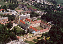
Zirc
| Zirc | ||||
|
||||
| Basic data | ||||
|---|---|---|---|---|
| State : | Hungary | |||
| Region : | Central Transdanubia | |||
| County : | Veszprém | |||
| Small area until December 31, 2012 : | Zirc | |||
| Coordinates : | 47 ° 16 ' N , 17 ° 52' E | |||
| Height : | 400 m | |||
| Area : | 37.4 km² | |||
| Residents : | 7,082 (Jan 1, 2011) | |||
| Population density : | 189 inhabitants per km² | |||
| Telephone code : | (+36) 88 | |||
| Postal code : | 8420 | |||
| KSH kódja: | 26499 | |||
| Structure and administration (status: 2014) | ||||
| Community type : | city | |||
| Mayor : | Péter Ottó (Fidesz-KDNP) | |||
| Postal address : | Március 15th tér 1 8420 zirc |
|||
| Website : | ||||
| (Source: A Magyar Köztársaság helységnévkönyve 2011. január 1st at Központi statisztikai hivatal ) | ||||
Zirc ( German Sirtz) is a small town with 7,157 inhabitants (2008) in the small area Zirc ( Zirci kistérség ), a Hungarian administrative unit ( LAU 1) within Veszprém County in Hungary . The place is the highest settlement (400 m) of its kind in the eastern part of the northern Bakonywald ("beech forest mountains") on the Cuha brook, 20 km north of Veszprém and 30 km north of the northern eastern corner of Lake Balaton .
Attractions
- Zirc Monastery (Zircium; also Boccan) is a Cistercian abbey .
- Arboretum Zirc
Twin cities
sons and daughters of the town
- Franz Xaver Ehmann (1801–1872), town builder and architect
- Antal Reguly (1819-1858), Hungarian ethnographer
- János Galambos (1940–2019), Hungarian mathematician
- Andreas Hejj (* 1956), adjunct professor at the Faculty of Psychology and Education at the Ludwig Maximilians University in Munich with German citizenship
Web links
Commons : Zirc - collection of images, videos and audio files
- Official website (Hungarian)
- Zirc , in: A Pallas nagy lexikona (Hungarian)


