
Zwenberg
|
Zwenberg ( scattered houses ) locality |
|||
|---|---|---|---|
|
|||
| Basic data | |||
| Pole. District , state | Spittal an der Drau (SP), Carinthia | ||
| Judicial district | Spittal an der Drau | ||
| Pole. local community | Reisseck ( KG Penk ) | ||
| Coordinates | 46 ° 54 '37 " N , 13 ° 15' 56" E | ||
| height | 1100 m above sea level A. | ||
| Residents of the village | 47 (January 1, 2020) | ||
| Building status | 22 (2001) | ||
| Postcodes | 9816 Penk | ||
| Official website | |||
| Statistical identification | |||
| Locality code | 02099 | ||
| Counting district / district | Penk (20644 001) | ||
| Source: STAT : index of places ; BEV : GEONAM ; KAGIS | |||

Zwenberg is a place in Mölltal in Upper Carinthia and village of the municipality Reisseck in the district of Spittal an der Drau in Carinthia .
geography
The place Zwenberg is a hamlet north of Penk and above the Tauern Railway .
The village presents itself as scattered houses , and also includes the individual layers Grutschnig, Straggonig (up from the valley) and Unter- and Obergrechenig (above Zwenberg), together about 20 houses with around 60 inhabitants, at heights between 950 and 1200 m ü. A. These are distributed on the Zwenberg, the valley shoulder of the Kampleck ( 2523 m above sea level ), which is an offshoot of the ridge of the Gamolnigspitze ( 2788 m above sea level ) of the Reisseck group (Hohe Tauern).
Neighboring places
|
(both in Obervellach ) |
||
| Gappen |
.svg)
|
|
| Penk |
|
History and sights
Document mentions of Zwenberg come from the years 1288 ( Sebeinperge ), 1333 ( Zewenperch ) and 1506 ( Zwenberg ). The name is derived from the Slovenian word Sebena .
The Zwenberg Marienkapelle is located on Zwenberg. This small path chapel was built by farmers from Zwenberg around 1825.

The Zwenberger Marienkapelle
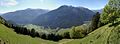
View of the Mölltal from Zwenberg from a height of approx. 1300 m


A beautiful hiking route leads into the Zwenberger Tal , but the end of the valley is impassable.
Individual evidence
- 20644 - Reißeck. Community data, Statistics Austria .

Parts of the municipality: Kolbnitz | Penk | Teuchl
Cadastral communities: Kolbnitz | Penk | Teuchl | Zandlach
Localities: Gappen | Hattelberg | Litzldorf | Mitterberg | Moss | Napplach | Oberkolbnitz | Penk | Polan | Preisdorf | Rottau | Sandbichl | Teuchl | Drafts | Lower Kolbnitz | Zandlach | Zwenberg
Villages: Kohlstatt • Napplach • Oberkolbnitz • Penk • Unterkolbnitz • Zandlach | Rotten: Gappen • Litzldorf • Preisdorf • Rottau | Settlements: Polan • Sandbichl • Tratten | Scattered houses: Hattelberg • Mittelberg • Moos • Roßwiese • Teuchl • Zwenberg | Other locations: Mölltheuer ruins • Zandlacher hut
Counting area: Kolbnitz adTauernbahn | Penk