Zandlach
|
Zandlach (village) locality cadastral community Zandlach |
||
|---|---|---|
|
|
||
| Basic data | ||
| Pole. District , state | Spittal an der Drau (SP), Carinthia | |
| Judicial district | Spittal an der Drau | |
| Pole. local community | Reisseck | |
| Coordinates | 46 ° 53 ′ N , 13 ° 19 ′ E | |
| height | 690 m above sea level A. | |
| Residents of the village | 244 (January 1, 2020) | |
| Building status | 103 (2001) | |
| Area d. KG | 39.18 km² | |
| Postcodes | 9815 Kolbnitz | |
| Official website | ||
| Statistical identification | ||
| Locality code | 01965 | |
| Cadastral parish number | 20644 | |
| Counting district / district | Kolbnitz adTauernbahn (20 644 000) | |
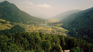
 View from Danielsberg out of Mölltal to the southeast, left on the valley slope the place Zandlach, Tauernbahn and above in front Mitterberg |
||
| Source: STAT : index of places ; BEV : GEONAM ; KAGIS | ||
Zandlach is a village in the Mölltal in Upper Carinthia , and a place and cadastral municipality of the municipality of Reißeck in the Spittal an der Drau district in Carinthia .
geography
The place is about 20 kilometers northeast of Spittal an der Drau and Millstätter See , on the left (sunny) side of the valley.
The local area also includes the Riekenbachtal , a side valley of the Mölltal to the north, with the Zandlacher hut ( 1527 m above sea level ). The village comprises around 100 buildings with around 270 inhabitants, at around 700 m above sea level. A. Height.
In addition to Zandlach itself, the northern part of the village of Oberkolbnitz , the Rotten Preisdorf and Rottau , the Polan and Sandbichl settlements , and the scattered houses of Hattelberg and Mitterberg belong to the cadastral community, with 39 km² . All of these places are localities of the parish. The area then includes the entire Riekenbachtal, up to Riedbock ( 2822 m above sea level ), Reisseck ( 2965 m above sea level ), Zaubernock ( 2944 m above sea level ), Riekenkopf ( 2898 m above sea level ), and Kampleck ( 2523 m above sea level ) and Schoberspitze ( 2573 m above sea level ), the two local mountains to the right and left of the Riekenbach valley.
- Neighborhoods
| Mitterberg | ||
| Oberkolbitz |

|
|
| Lower Kolbitz | Rottau |
- Neighboring catastral communities
| Dornbach (Gem. Malta ) | Trebesing (Gem. Trebesing) | |
| Penk |

|
Mühldorf (Gem. Mühldorf) |
| Teuchl |
history
Zandlach was one of the two parts of the municipality of Kolbnitz an der Tauernbahn , with the municipal reform in 1973 Kolbnitz, Mühldorf and Penk were merged to form the municipality of Reißeck (Mühldorf left in 1992).
Individual evidence
- 20644 - Reißeck. Community data, Statistics Austria .
- ↑ the official coordinate of the place Oberkolbnitz is on the cadastral boundary to Kolbnitz

