
Kolbnitz
|
Kolbnitz (part of the municipality, counting district Kolbnitz an der Tauernbahn) |
|||
|---|---|---|---|
|
|||
| Basic data | |||
| Pole. District , state | Spittal an der Drau (SP), Carinthia | ||
| Judicial district | Spittal an der Drau | ||
| Pole. local community | Reisseck | ||
| Coordinates | 46 ° 53 ' N , 13 ° 18' E | ||
| height | 613 m above sea level A. | ||
| Residents of the stat. An H. | 1616 (2001) | ||
| Building status | 559 (2001) | ||
| surface | 51.37 km² | ||
| Postcodes | 9815 Kolbnitz | ||
| Official website | |||
| Statistical identification | |||
| Counting district / district | Kolbnitz adTauernbahn (20 644 000) | ||
_seen_from_Danielsberg.jpg) View from Danielsberg towards Kolbnitz, out of Mölltal to the southeast |
|||
| (. Gkz 20644) former community today Zählsprengel of Reißeck , the cadastral included Kolbnitz and Zandlach Source: STAT : Gazetteer ; BEV : GEONAM ; KAGIS |
|||

Kolbnitz is a former municipality (Kolbnitz an der Tauernbahn) in the Mölltal in Upper Carinthia and today counting district and cadastral municipality of the municipality of Reißeck in the Spittal an der Drau district in Carinthia . As part of the municipality, the term is still customary in the area.
geography
Kolbnitz is about 20 kilometers northwest of Spittal an der Drau and Lake Millstatt .
It includes the three villages of Oberkolbnitz , Unterkolbnitz and Zandlach , the Rotten Preisdorf and Rottau , the settlements of Polan , Sandbichl and Tratten , as well as the scattered houses Hattelberg and Mittelberg . All ten places are localities of the municipality. With the exception of Tratten, all villages are on the left (north) of the Möll . This counting district Kolbnitz ad Tauernbahn has around 560 buildings with around 1,600 inhabitants and an area of 51.4 km².
| Kolbnitz ( cadastral community ) | |
|---|---|
| Basic data | |
| Pole. District , state | Spittal an der Drau , Carinthia |
| Judicial district | Spittal an der Drau |
| Pole. local community | Reisseck |
| Coordinates | 46 ° 51 ′ 46 " N , 13 ° 17 ′ 36" E |
| Area d. KG | 12.19 km² |
| Statistical identification | |
| Cadastral parish number | 73304 |
| Source: STAT : index of places ; BEV : GEONAM ; KAGIS | |
The cadastral municipality of Kolbnitz is only part of the area with 12.1 km², and includes the village of Unterkolbnitz, the southern part of the village of Oberkolbnitz, and the right , north-facing locations of the Möll valley, with the village of Tratten, and up to the Salzkofel ( 2498 m o. A. ).
- Neighboring catastral communities
| Penk | Zandlach | |
.svg)
|
||
| Teuchl | Obergottesfeld (community Sachsenburg ) | Mühldorf (Gem.) |
history
A little west of Kolbnitz is the Danielsberg , a Celtic place of worship. Around 15 BC The Romans occupied the area and left their traces, e.g. B. the Roman road and remains of a Hercules temple on the Danielsberg.
In the first mention in 1124 Kolbnitz was mentioned as a cholomunze . The name is of Slavic origin and is believed to be derived from Collmiza , which means small rounded mountain (anthill) . According to Dr. Otto Kronsteiner from the Institute for Slavonic Studies in Salzburg, the name goes back to the name of the Roman settlement on Danielsberg: Colomunitio , consisting of Colo (hill) and munitio (secured, reinforced, fortified). The name became Cholomunze (1124) and finally Kolbnitz .
At that time, the area was owned by the Counts of Lurn , bailiffs of the Freising diocese . The last Lurner, Bishop Altmann von Trient, handed over his church in Kolbnitz to Salzburg in 1126 . Most of the area then became the property of the Counts of Gorizia . In the 15th century the property fell to the Habsburgs .
The former municipality of Kolbnitz an der Tauernbahn was merged with Mühldorf and Penk to form the municipality of Reisseck during the municipal reform in 1973 (Mühldorf left again in 1992). The term is still common locally, as the community of Reißeck nature experience region Kolbnitz – Penk – Teuchl calls itself . The station of the Tauernbahn , on the slope above between Zandlach and Rottau, is also called Kolbnitz .
Culture and sights
Transport and infrastructure

The valley stations of the Reißeckbahn and Kreuzeckbahn are located in Kolbnitz . Both cable cars were originally needed during the construction of the reservoirs for the two hydropower plants , but today they are mainly used for tourism.
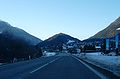
Kolbnitz with Danielsberg in the background

Roman path with Klaubsteinmauer (dry stone wall) in winter

View from Kolbnitz towards the Kreuzeck group


Personalities
- Josef Viehhauser (* 1950), star chef
Web links
Individual evidence
- 20644 - Reißeck. Community data, Statistics Austria .
- ↑ the official coordinate of the place Oberkolbnitz is on the cadastral boundary to Zandlach
- ^ After Josef "Sepp" Messner: Danielsberg in Mölltal, Carinthia, a declaration of love . 1992, publisher: The Friends of Danielsberg
- ↑ Bf Altmann von Trient ( page no longer available , search in web archives ) Info: The link was automatically marked as defective. Please check the link according to the instructions and then remove this notice.

Parts of the municipality: Kolbnitz | Penk | Teuchl
Cadastral communities: Kolbnitz | Penk | Teuchl | Zandlach
Localities: Gappen | Hattelberg | Litzldorf | Mitterberg | Moss | Napplach | Oberkolbnitz | Penk | Polan | Preisdorf | Rottau | Sandbichl | Teuchl | Drafts | Lower Kolbnitz | Zandlach | Zwenberg
Villages: Kohlstatt • Napplach • Oberkolbnitz • Penk • Unterkolbnitz • Zandlach | Rotten: Gappen • Litzldorf • Preisdorf • Rottau | Settlements: Polan • Sandbichl • Tratten | Scattered houses: Hattelberg • Mittelberg • Moos • Roßwiese • Teuchl • Zwenberg | Other locations: Mölltheuer ruins • Zandlacher hut
Counting area: Kolbnitz adTauernbahn | Penk