
Gachetá: Difference between revisions
m robot Adding: pt:Gachetá |
No edit summary Tags: Mobile edit Mobile web edit |
||
| (37 intermediate revisions by 25 users not shown) | |||
| Line 1: | Line 1: | ||
{{distinguish|Guachetá}} |
|||
[[Image:MunsCundinamarca Gacheta.png|thumb|right|250px|Location of the town and municipality of '''Gacheta''' in [[Cundinamarca Department]].]] |
|||
{{Infobox settlement |
|||
|name = Gachetá, Cundinamarca |
|||
|native_name = |
|||
|nickname = |
|||
|motto = |
|||
|etymology = [[Chibcha language|Muysccubun]]: "Behind our farmfields" |
|||
|settlement_type = [[Municipalities of Colombia|Municipality]] and town |
|||
|image_skyline = Iglesia de Gacheta.jpg |
|||
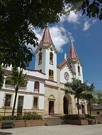
|image_caption = Church of Gachetá |
|||
|image_flag = Flag of Gachetá.svg |
|||
|image_seal = EscudoGacheta.svg |
|||
|image_map = Colombia - Cundinamarca - Gachetá.svg |
|||
|map_caption = Location of the municipality and town of Gachetá in the Boyacá Department of Colombia |
|||
|pushpin_map = Colombia |
|||
|pushpin_map_caption = Location in Colombia |
|||
|subdivision_type = Country |
|||
|subdivision_name = Colombia |
|||
|subdivision_type1 = [[departments of Colombia|Department]] |
|||
|subdivision_name1 = [[Cundinamarca Department|Cundinamarca]] |
|||
|subdivision_type2 = Province |
|||
|subdivision_name2 = [[Guavio Province]] |
|||
|leader_title = Mayor |
|||
|leader_name = Julio Enrique Aguilera Jiménez<br />(2016–2019) |
|||
|established_title = Founded |
|||
|established_date = 2 April 1593 |
|||
|founder = [[Miguel de Ibarra]] |
|||
|area_magnitude = |
|||
|area_total_km2 = 262.16 |
|||
|area_total_sq_mi = |
|||
|area_land_km2 = |
|||
|area_land_sq_mi = |
|||
|area_water_km2 = |
|||
|area_water_sq_mi = |
|||
|area_water_percent = |
|||
|area_urban_km2 = 0.96 |
|||
|area_urban_sq_mi = |
|||
|area_metro_km2 = |
|||
|area_metro_sq_mi = |
|||
|population_as_of = 2015 |
|||
|population_note = |
|||
|population_total = 11086 |
|||
|population_density_km2 = auto |
|||
|population_density_sq_mi = |
|||
|population_metro = |
|||
|population_density_metro_km2 = |
|||
|population_density_metro_sq_mi = |
|||
|population_urban = 3689 |
|||
|coordinates = {{coord|4|49|03.2|N|73|38|09.7|W|display=inline,title}} |
|||
|timezone = Colombia Standard Time |
|||
|utc_offset = -5 |
|||
|timezone_DST = |
|||
|utc_offset_DST = |
|||
|elevation_m = 1745 |
|||
|elevation_ft = |
|||
|website = {{URL|http://www.gacheta-cundinamarca.gov.co/|Official website}} |
|||
|footnotes = |
|||
}} |
|||
'''Gachetá, Cundinamarca''' is a municipality and town of [[Colombia]], capital of the [[Guavio Province]], part of the [[Departments of Colombia|department]] of [[Cundinamarca Department|Cundinamarca]]. The urban centre of Gachetá is situated at an altitude of {{convert|1745|m|ft}} in the [[Cordillera Oriental (Colombia)|Eastern Ranges]] of the Colombian [[Andes]]. The municipality borders [[Machetá]] and [[Manta, Cundinamarca|Manta]] in the north, the department of [[Boyacá Department|Boyacá]] and [[Ubalá]] in the east, [[Gama, Cundinamarca|Gama]] and [[Junín, Cundinamarca|Junín]] in the south and [[Guatavita]] in the west.<ref name=websiteGacheta>[https://archive.today/20140310085035/http://www.gacheta-cundinamarca.gov.co/informacion_general.shtml Official website Gachetá] {{in lang|es}}</ref> |
|||
== Etymology == |
|||
'''Gacheta''' is a municipality and town of [[Colombia]] in the [[Departments of Colombia|department]] of [[Cundinamarca]]. |
|||
The name Gachetá comes from [[Chibcha language|Muysccubun]] and means "behind our farmfields".<ref name=websiteGacheta /> |
|||
== History == |
|||
| ⚫ | |||
Gachetá before the [[Spanish conquest of the Muisca|Spanish conquest]] was inhabited by the [[Muisca people|Muisca]], organised in their loose [[Muisca Confederation]]. Gachetá was part of the domains of the ''[[cacique]]'' of Guatavita. |
|||
Modern Gachetá was founded on April 2, 1593, by Miguel de Ibarra.<ref name=websiteGacheta /> |
|||
{{coord|4|55|N|73|40|W|display=title|region:CO_type:adm2nd_source:GNS-enwiki}} |
|||
== Economy == |
|||
| ⚫ | |||
Main economical activity of Gachetá is agriculture, with main products [[coffee]], [[maize]], [[yuca]], [[arracacha]], [[potato]]es, [[bean]]s, [[sugarcane]] and [[blackberry|blackberries]] cultivated.<ref name=websiteGacheta /> |
|||
[[Category:Cities, towns and villages in the Cundinamarca Department]] |
|||
== Gallery == |
|||
{{Colombia-geo-stub}} |
|||
<gallery mode=packed heights=180px> |
|||
File:Gacheta.JPG|Central square |
|||
File:Iglesia de Gacheta Cundinamarca.jpg|Church |
|||
File:Guaviio.JPG|Guavio Reservoir |
|||
</gallery> |
|||
{{clear left}} |
|||
== References == |
|||
{{Commons category|Gachetá}} |
|||
{{reflist}} |
|||
| ⚫ | |||
{{DEFAULTSORT:Gacheta}} |
|||
[[es:Gachetá]] |
|||
| ⚫ | |||
[[pt:Gachetá]] |
|||
[[Category:Populated places established in 1593]] |
|||
[[Category:1593 establishments in the Spanish Empire]] |
|||
Latest revision as of 00:10, 15 March 2024
Gachetá, Cundinamarca | |
|---|---|
Municipality and town | |
 Church of Gachetá | |
 Flag  Seal | |
| Etymology: Muysccubun: "Behind our farmfields" | |
 Location of the municipality and town of Gachetá in the Boyacá Department of Colombia | |
 Gachetá, Cundinamarca Location in Colombia | |
| Coordinates: 4°49′03.2″N 73°38′09.7″W / 4.817556°N 73.636028°W | |
| Country | Colombia |
| Department | Cundinamarca |
| Province | Guavio Province |
| Founded | 2 April 1593 |
| Founded by | Miguel de Ibarra |
| Government | |
| • Mayor | Julio Enrique Aguilera Jiménez (2016–2019) |
| Area | |
| • Municipality and town | 262.16 km2 (101.22 sq mi) |
| • Urban | 0.96 km2 (0.37 sq mi) |
| Elevation | 1,745 m (5,725 ft) |
| Population (2015) | |
| • Municipality and town | 11,086 |
| • Density | 42/km2 (110/sq mi) |
| • Urban | 3,689 |
| Time zone | UTC-5 (Colombia Standard Time) |
| Website | Official website |
Gachetá, Cundinamarca is a municipality and town of Colombia, capital of the Guavio Province, part of the department of Cundinamarca. The urban centre of Gachetá is situated at an altitude of 1,745 metres (5,725 ft) in the Eastern Ranges of the Colombian Andes. The municipality borders Machetá and Manta in the north, the department of Boyacá and Ubalá in the east, Gama and Junín in the south and Guatavita in the west.[1]
Etymology[edit]
The name Gachetá comes from Muysccubun and means "behind our farmfields".[1]
History[edit]
Gachetá before the Spanish conquest was inhabited by the Muisca, organised in their loose Muisca Confederation. Gachetá was part of the domains of the cacique of Guatavita.
Modern Gachetá was founded on April 2, 1593, by Miguel de Ibarra.[1]
Economy[edit]
Main economical activity of Gachetá is agriculture, with main products coffee, maize, yuca, arracacha, potatoes, beans, sugarcane and blackberries cultivated.[1]
Gallery[edit]
-
 Central square
 -
 Church
 -
 Guavio Reservoir


References[edit]
- ^ a b c d Official website Gachetá (in Spanish)