Guasca
| Guasca | ||
|---|---|---|
|
Coordinates: 4 ° 52 ′ N , 73 ° 53 ′ W Guasca on the map of Colombia
|
||
|
Location of the municipality of Guasca on the map of Cundinamarca
|
||
| Basic data | ||
| Country | Colombia | |
| Department | Cundinamarca | |
| City foundation | 1600 | |
| Residents | 15,727 (2019) | |
| City insignia | ||
| Detailed data | ||
| surface | 346 km 2 | |
| Population density | 45 people / km 2 | |
| height | 2700 m | |
| Time zone | UTC -5 | |
| City Presidency | Miguel Arturo Garavito Díaz (2016-2019) | |
| Website | ||
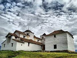
| Guasca Church | ||
| View of Guasca | ||
| The Capilla de Siecha | ||
Guasca is a municipality ( municipio ) in the Colombian department of Cundinamarca . The name has its origin in the language of the Chibcha and means "surrounded by mountains".
Geography and climate
Guasca is located at 2,710 meters above sea level about 50 kilometers northeast of Bogotá and extends over 346 km². 8.8 km² of this is built-up area; the rest is used for agriculture or lies fallow. The average temperature is 13 ° C. The municipality borders on Guatavita and Tocancipá to the north, Junín to the east, La Calera and Fómeque to the south and Sopó to the west . On the territory of the municipality there is part of the Chingaza Natural Park , which includes the Lagunas de Siecha , three mountain lakes that were sacred places for the Muiscas .
population
The municipality of Guasca has 15,727 inhabitants, of whom 5642 live in the urban part (cabecera municipal) of the municipality (as of 2019).
history
Guasca goes back to an indigenous Muiscas settlement that existed before the Spanish arrived. The Spanish town was officially founded in 1600 by Luis Enríquez. Another founding date is given as 1639. Both dates, however, refer to a short visit from a representative of the Spanish crown with the aim of pushing the indigenous population into the framework of the Spanish settlement around the Christian chapel. The original center of Guasca was around the Capilla de Siecha . The place was later moved to its current location. Guasca has been a parish since 1778.
structure
The municipality of Guasca consists of the urban center and 14 rural veredas :
- 0: Centro Urbano
- 1: Santuario
- 2: Flores
- 3: Santa Bárbara
- 4: Pastor Ospina (named after the brother of Mariano Ospina Rodríguez )
- 5: Floresta
- 6: San José
- 7: San Isidro
- 8: Mariano Ospina
- 9: Santa Lucía
- 10: El Salitre (Salitre Alto y Salitre Bajo)
- 11: Santa Isabel de Potosí (formerly: Potosí)
- 12: La Trinidad
- 13: Santa Ana
- 14: Concepción
economy
The main industries of Guasca are agriculture and milk production . Ornamental plants , potatoes and strawberries are particularly grown .
sons and daughters of the town
- Mariano Ospina Rodríguez (1805–1885), Colombian President
Web links
- Alcaldia de Guasca. Alcaldía de Guasca - Cundinamarca, accessed on June 9, 2019 (Spanish, website of the municipality of Guasca).
swell
Individual evidence
- ↑ a b c d Historia de Guasca. Alcaldía de Guasca - Cundinamarca, accessed on June 9, 2019 (Spanish, information on the municipality).
- ↑ ESTIMACIONES DE POBLACIÓN 1985 - 2005 Y PROYECCIONES DE POBLACIÓN 2005 - 2020 TOTAL DEPARTAMENTAL POR ÁREA. (Excel; 1.72 MB) DANE, May 11, 2011, accessed on June 9, 2019 (Spanish, extrapolation of the population of Colombia).


