Girardot (Colombia)
| Girardot | ||
|---|---|---|
|
Coordinates: 4 ° 18 ′ N , 74 ° 49 ′ W Girardot on the map of Colombia
|
||
|
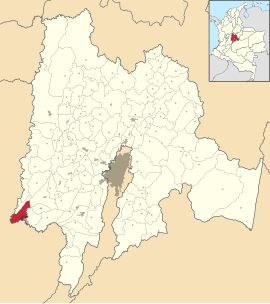
Location of the municipality of Girardot on the map of Cundinamarca
|
||
| Basic data | ||
| Country | Colombia | |
| Department | Cundinamarca | |
| City foundation | October 9, 1852 | |
| Residents | 107,324 (2019) | |
| - in the metropolitan area | 146.778 | |
| City insignia | ||
| Detailed data | ||
| surface | 129 km 2 | |
| Population density | 832 inhabitants / km 2 | |
| height | 289 m | |
| Waters | Río Magdalena , Río Bogotá | |
| Time zone | UTC -5 | |
| City Presidency | José Francisco Lozano Sierra (2020-2023) | |
| Website | ||
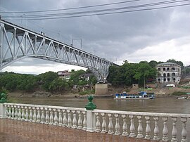
| Bridge over the Río Magdalena between Girardot and Flandes | ||
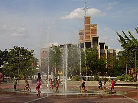
| Cathedral and main park in Girardot | ||
| View of Girardot | ||
Girardot is a municipality ( municipio ) in Colombia in the department of Cundinamarca .
geography
Girardot is located in the Cundinamarca , 134 km southwest of Bogotá on the east bank of the Río Magdalena at an altitude of 289 m in the province of Alto Magdalena , of which it is the capital. The climate is tropical , the average temperature is 33 ° C. The municipality is bordered to the north by Nariño and Tocaima , to the south by Flandes in Tolima and the Río Magdalena, to the west by Nariño, the Río Magdalena and Coello in Tolima and to the east by Ricaurte and the Río Bogotá . Girardot, together with Flandes and Ricaurte, forms the unofficial Girardot metropolitan region .
population
The municipality of Girardot has 107,324 inhabitants, of whom 103,846 live in the urban part (cabecera municipal) of the municipality. 146,778 people live in the metropolitan region (as of 2019).
tourism
Girardot is very popular as an excursion destination for the inhabitants of the capital Bogotá , especially since the road from Bogotá via Melgar to Girardot is largely safe from guerrilla raids . This very busy route, one of Colombia's main arteries, is famous for its scenic beauty, but also notorious for its numerous accidents.
shipping
Girardot is the farthest upstream port of the Río Magdalena, which can still be used by larger river boats. Girardot used to be of great importance as an inland port for the metropolis of Bogotá, but shipping has almost come to a standstill in recent years due to the armed conflict . Today the city lives almost exclusively from agriculture and a booming day tourism, which manifests itself in numerous markets, shops and an overall very colorful and lively atmosphere.
Camino Real
The so-called Camino Real begins in Girardot , the historical riding and footpath of the Spanish viceroys of the viceroyalty of New Granada to Bogotá. It leads via Viotá , Mesitas del Colegio and Santandercito to the Colombian capital and overcomes an altitude difference of 2400 m in the valley of the Río Bogotá .
Infrastructure
Girardot has one airport, Santiago Vila Airport ( IATA code : GIR ), which is located in the neighboring municipality of Flandes .
Web links
- Alcaldia de Girardot. Alcaldía de Girardot - Cundinamarca, accessed February 20, 2019 (Spanish, municipality website).
Individual evidence
- ^ Información del municipio. Alcaldía de Girardot - Cundinamarca, accessed February 20, 2019 (Spanish, information on the municipality).
- ↑ ESTIMACIONES DE POBLACIÓN 1985 - 2005 Y PROYECCIONES DE POBLACIÓN 2005 - 2020 TOTAL DEPARTAMENTAL POR ÁREA. (Excel; 1.72 MB) DANE, May 11, 2011, accessed on February 20, 2019 (Spanish, extrapolation of the population of Colombia).


